Bathford and Batheaston Site Options
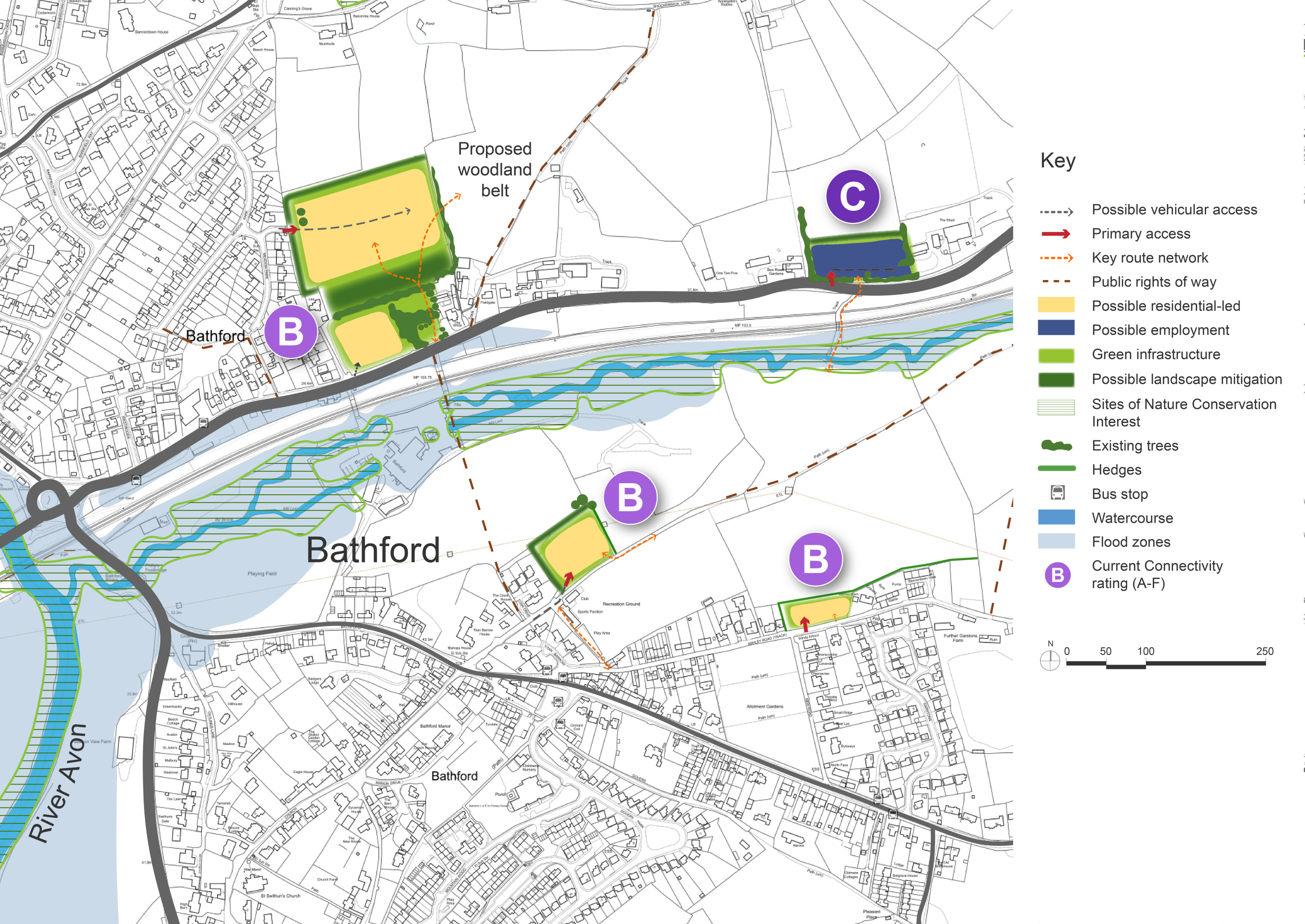
The Site Options for Bathford and Batheaston are being presented together. Bathford Nurseries and Box Road sites are located on the edge of Batheaston. The Land North of the Recreation Ground and Ashley Road are located with Bathford Village itself. The sites collectively have the potential to deliver 125 – 160 new homes.
Bathford and Batheaston are closely linked villages located to the east of Bath, forming part of the wider Bath urban fringe. Both villages benefit from high connectivity, including proximity to the A4 and public transport links into Bath, and a broad range of local services and facilities. The area is characterised by its attractive landscape setting, with the River Avon to the south and surrounding hills forming part of the Cotswolds National Landscape. The villages also lie within the indicative setting of the Bath World Heritage Sites, which adds further sensitivity to development proposals.
Batheaston, while constrained by Green Belt and landscape designations, functions as a key service centre for the area. Bathford, slightly more detached, has a moderate range of services and some primary school capacity. Together, the settlements present a complex planning context where growth must be carefully balanced against environmental and heritage constraints.
Two areas on Box Road, within Bathford parish but on the edge of Batheaston, are identified as options for housing development. The lower parcel (Bathford Nurseries South) could accommodate 45-60 homes, while the upper parcel (Bathford Nurseries North), with proposed access from Meadow Park, has capacity for 55-70 homes. Both sites are within the Green Belt and National Landscape, and assessment will need to be undertaken of the impact on the Green Belt of possible development and whether either of the sites would meet the definition of ‘Grey Belt’ under the revised NPPF. Overall capacity would be guided by infrastructure capacity, landscape mitigation (including a new woodland belt to the north), and biodiversity enhancement. Pathways are proposed to connect the sites with existing employment zones and residential areas, improving permeability and access to services. Further along Box Road, a separate site is identified for economic use, supporting local employment opportunities.
Within Bathford itself, two small-scale sites are considered for proportionate development. Land north of the recreation ground, adjacent to Titan Drive, has been promoted for affordable housing and could accommodate between 15 and 20 homes, though this would need to be balanced with limited access along Bathford Hill. A second site at Ashley Road could accommodate up to 10 dwellings as an infill scheme, but access will require careful consideration due to the narrowness of the road.
In Batheaston, no larger-scale site options have been identified due to significant environmental and heritage constraints. However, a small area of previously developed land within the village is included within the Housing Development Boundary (adopted Placemaking Plan, 2017). While not allocated due to limited capacity and deliverability concerns, its inclusion enables modest housing to come forward in future. This presents an opportunity to make more effective use of underused land and to support local aspirations for improvements to the surrounding area, including enhanced recreational facilities.
Connectivity scores shown in the site options plan below are based on the Department for Transport’s A–J grading, where A is the highest within B&NES.
Bathford and Batheaston Site Options – Indicative plan
Click to enlarge
Bathford and Batheaston Site Options – Key information
| Element | Description |
| Development opportunities | All sites
|
| Constraints |
|
| Mitigation |
|
| DfT current connectivity rating |
|
| Further evidence required |
|