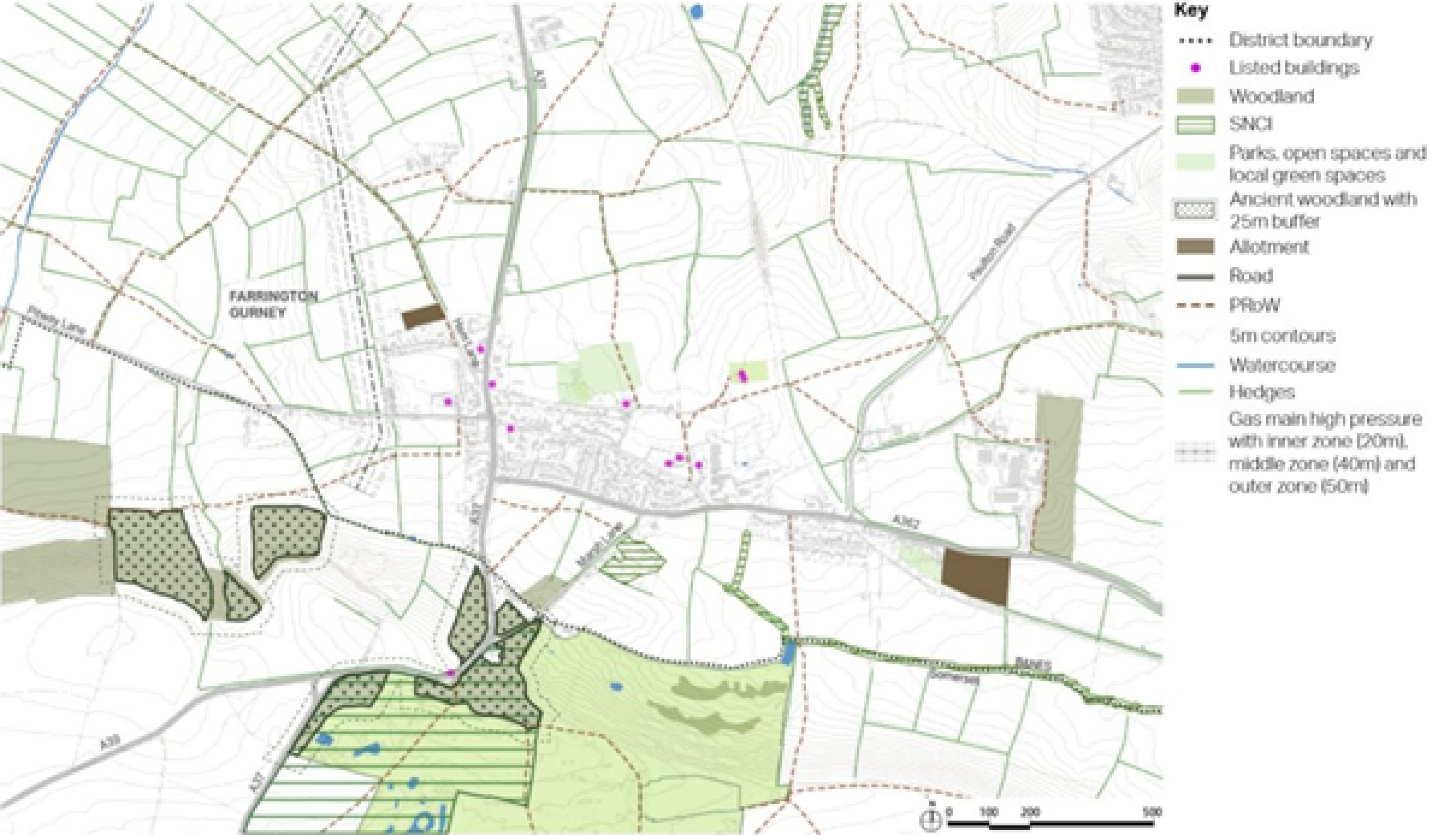
Farrington Gurney - context
The Somer Valley Links project and Somer Valley Enterprise Zone will provide an off road cycle path into Midsomer Norton. The Somer Valley Links project also proposes a new mobility hub at Farrington Gurney.
Historically, the development of the village has moved away from St John’s Church, which is a listed building and now stands on its own in fields to the east of the village. The isolated setting of the church will be an important consideration for any development proposals.
Farrington Gurney is surrounded by rolling, relatively flat countryside. The gentle escarpment to the south creates a boundary for any proposed development. The Nature Reserve at Hollow Marsh and countryside are accessible via local Public Rights of Way.
The main constraint is that almost all of the land within the area of search is classified as Grade 1 in the Agricultural Land Classification, and land adjacent, to the south, is classified as Grade 3a. Grade 1 and 3a are referred to as ‘best and most versatile’ land, where development should be avoided.
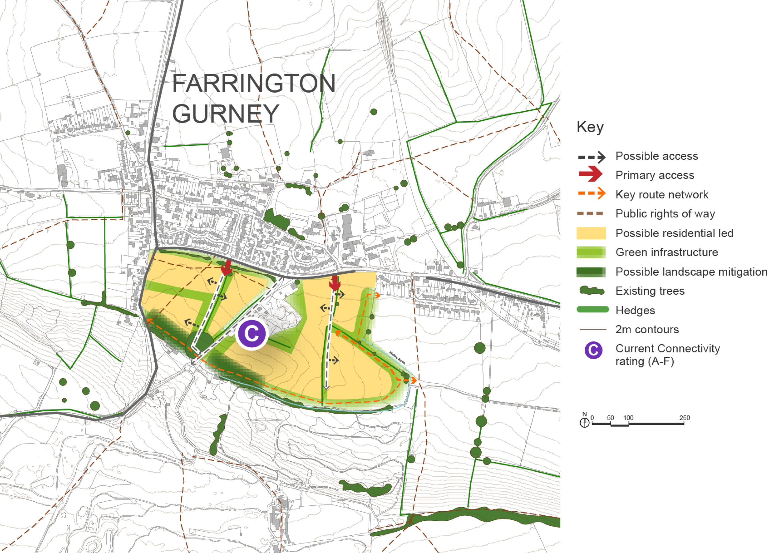
There are opportunities for a good size residential and landscape-led development. The new mobility hub along the A37 would help with access to public transport, and active travel is promoted through the Somer Valley Links.
To improve walking, wheeling and cycling permeability throughout the village, the existing main roads need to be downgraded and vehicle speeds need to be reduced to provide improved safety. The existing pedestrian and cycle routes need to be improved and widened. A thorough archaeological investigation would be needed as part of the planning and development process.
There is an Air Quality Management Area within Farrington Gurney at the junction of the A37 and A362. An increase in development to the village may impact on air quality and any new development may need to be designed so as to avoid damage to future air quality.
Farrington Gurney – site context
Thanks for your patience whilst we create a higher quality image
Click to enlarge
- Setting of the existing Grade II listed church.
- Setting of the surrounding landscape.
- Impact of development on the existing highway network and access to public transport
- Impact on the Farrington Gurney Air Quality Management Area (AQMA) and AQMA in Temple Cloud
- Distance from Midsomer Norton town centre is over 3 miles.
- Secondary age pupils from any new development at Farrington Gurney would need to be transported to Norton Hill School in Midsomer Norton, at cost to the council. These pupils will not be able to travel to school sustainably by active modes.
- Agricultural land classification
The following list sets out the key priorities and objectives for Farrington Gurney. Many of the priorities can be addressed by new development. However, there are some priorities that won’t be addressed through new development but will be addressed through other policies in the local plan or initiatives undertaken by the council or by other stakeholders.
- Around 500 homes could be provided, including housing that is affordable and meets local needs
- The existing primary school has limited capacity to accept new children. Therefore, a new school would need to be provided which influences the scale or quantum of development required.
- Opportunities to improve local services and facilities.
- There is an opportunity to connect to the Somer Valley links project which along with the Somer Valley Enterprise Zone will provide an off-road cycle link to Midsomer Norton. This will provide cycle connections to the network in Midsomer Norton.
- Landscape mitigation would be required to soften the impact of the development.
- Ensure any new development provides mitigation measures so as not to cause harm to the Air Quality Management Area.
The previous options consultation included a strategic option for housing to the north of the village. This land is situated wholly within Grade 1 farmland and therefore its development would result in a substantial loss of Grade 1 farmland.
The land to the north of the village also sits adjacent to the Grade II listed St John the Baptist Church. The church’s isolated setting away from the village is integral to its history and therefore development in this area could harm the historic setting of the church.
Therefore the option of development to the north of the village is not proposed to be taken forward.
The development option to the south of the village proposed below would require vehicular access off the A37, which would need to be downgraded (e.g. speeds reduced) as it passes through the village, in order that safe pedestrian and cycle routes and crossings can be provided.
Green links throughout the residential areas would enhance local biodiversity and provide a high-quality public realm and direct access to the countryside.
The new development needs to be respectful of the historic character of the village when it comes to connecting to the existing settlement. Historic routes could be used for active travel, and it is important to retain and enhance the local character of the settlement.
Development could also incorporate small scale economic uses that are compatible with a residential area.
The existing road running through the site (Marsh Lane) would become an important connecting route, providing access to the main body of development. There will be additional green links and active travel routes connecting to the existing village and, in particular to the various amenities and services, such as the school and the Co-op.
Residential parcels would be located within a series of green corridors and buffers to protect the Site of Nature Conservation Interest in the centre of the area and Rush Hill Wood, an Ancient Woodland to the south. Marsh Lane which connects the two areas of woodland is identified as a Nature Recovery Network opportunity for woodland connectivity. The buffer along the southern boundary also helps protect the setting of the Grade II registered park and garden of Ston Easton Park to the south.
Planting along the A362, which runs between the existing settlement and the new development, would help to integrate it into the settlement, framing views towards the ridge to the south and to key buildings within the existing settlement.
There would be a need for pedestrian improvements along the A362, which provides access for vehicles and active travel modes to the development. The Somer Valley Links proposes an active travel route along the road to connect with active travel links in Midsomer Norton.
Evidence from DEFRA mapping suggest that the land is partly Grade 1 farmland (high grade) and partly Grade 3 (lower grade). Anecdotal evidence has been provided through the previous options consultation that none of the site is Grade 1. Therefore, if this site were to be allocated for development in the Draft Local Plan further investigation would be required to ascertain if any of the site is high grade farmland.
Marsh Lane colliery is an undesignated heritage asset and important landscape feature. Its setting should be carefully considered if this site were to be allocated.
There is limited access to public transport particularly going east towards Midsomer Norton. Further crossing points would be required to provide pedestrian access to bus stops.
Farrington Gurney Option 1 – indicative plan
Click to enlarge
The option for 400-500 homes would yield a quantum of development that could facilitate a new 210-place primary school. However, current assessment of primary school admissions suggests that the school could potentially accommodate children generated by a residential development providing around 50 homes. Therefore, option 2 proposes a smaller development to the south of the village for 50 homes.
Farrington Gurney Site Options – Key information
| Element |
Description |
|
| Option 1 | Option 2 | |
| Development opportunities |
|
|
| Constraints |
|
|
| Mitigation |
|
|
| DfT current connectivity rating |
|
|
| Further evidence required |
|
|