North Keynsham Site Option
The North Keynsham site provides the opportunity to deliver a sustainably located mix-use development compromising 1,900 – 2,400 new homes. Alongside new housing there is the opportunity to deliver a range of community and leisure facilities as part of development, including a primary school, retail provision, community facilities and a cultural facility, such as a hall with theatre, for use by local communities.
Currently located in the Green Belt, further assessment is required before the site can be released. There are also many other constraints that would need to be resolved through a range of mitigations to make the development of the site acceptable in planning terms.
North Keynsham is located to the east of Keynsham town centre, and south of the River Avon, separated from the town by the railway line running between Bristol and Bath. Narrow access points via various bridges and tunnels connect the site to Keynsham.
The site is located in close proximity to the A4, the Bristol and Bath Cycle Path and Keynsham Train Station, all of which provide direct access to Bath and Bristol by bus, train and bicycle.
Some constraints exist across the site due to its location, existing land uses, and poor connections to its surroundings (see constraints in table below). However, through careful masterplanning and provision of mitigation where required, the site is considered to be a good option for development due to its highly sustainable location.
Due to its highly sustainable location, if this area is allocated for development in the Local Plan, its deliverable capacity should be optimised. With this in mind, further evidence base work is being undertaken to determine whether a higher quantum of development than set out below could be provided through mitigation of on-site constraints imposed by the water recycling plant and gas pipeline.
Additional landscape evidence work is also being undertaken to assess the impact of development on the Cotswold National Landscape and its setting, both from individual site options and cumulatively considering wider development along the A4. In addition, work is underway to assess needs and opportunities for strategic green infrastructure and nature recovery.
The option for potential development at West Saltford (see page 117), will need to be considered in conjunction with this North Keynsham option, with regards to maintaining a sufficient green gap between Keynsham and Saltford to avoid coalescence and provide high quality accessible open space, which are priorities for both settlements.
A road will be required to access the development site and it is envisaged that it will also play a more strategic role as a relief route, removing through traffic from Keynsham town centre, to the wider benefit of the town and enabling a greater focus on sustainable modes of transport on the town centre area network.
The site requires provision of significant infrastructure, not only from a transport perspective, but also to provide services and facilities for future residents. Optimising residential development at the site is considered to be important to both financially support provision of this infrastructure, and to secure its long-term use.
The site is located in the Green Belt. Any release of land from the Green Belt and subsequent allocation for development will need to demonstrate exceptional circumstances. To understand and consider the impact of potential development on the Green Belt an assessment of the extent to which different parcels of land serve the five purposes is being undertaken. The emerging Stage 1 Strategic Green Belt Assessment being carried out by WECA and the constituent authorities will assess the site for its contribution towards meeting the five Green Belt purposes and also whether it has potential to meet the definition of grey belt set out in the NPPF and updated Planning Practice Guidance, which is sequentially preferable to developing greenfield Green Belt in national policy. The assessment work is ongoing and will inform the Draft Local Plan. It is likely that following the Stage 1 Strategic Green Belt Assessment a more detailed (Stage 2) assessment of the impact of development on more specific areas of the Green Belt will also be required.
North Keynsham context plan
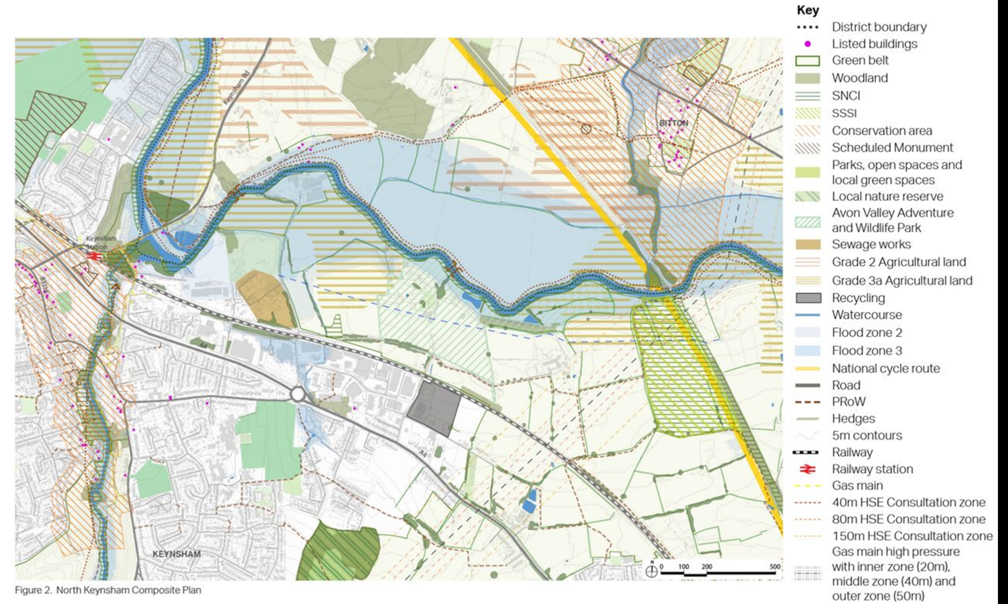
Click to enlarge
North Keynsham Site Option – Indicative plan
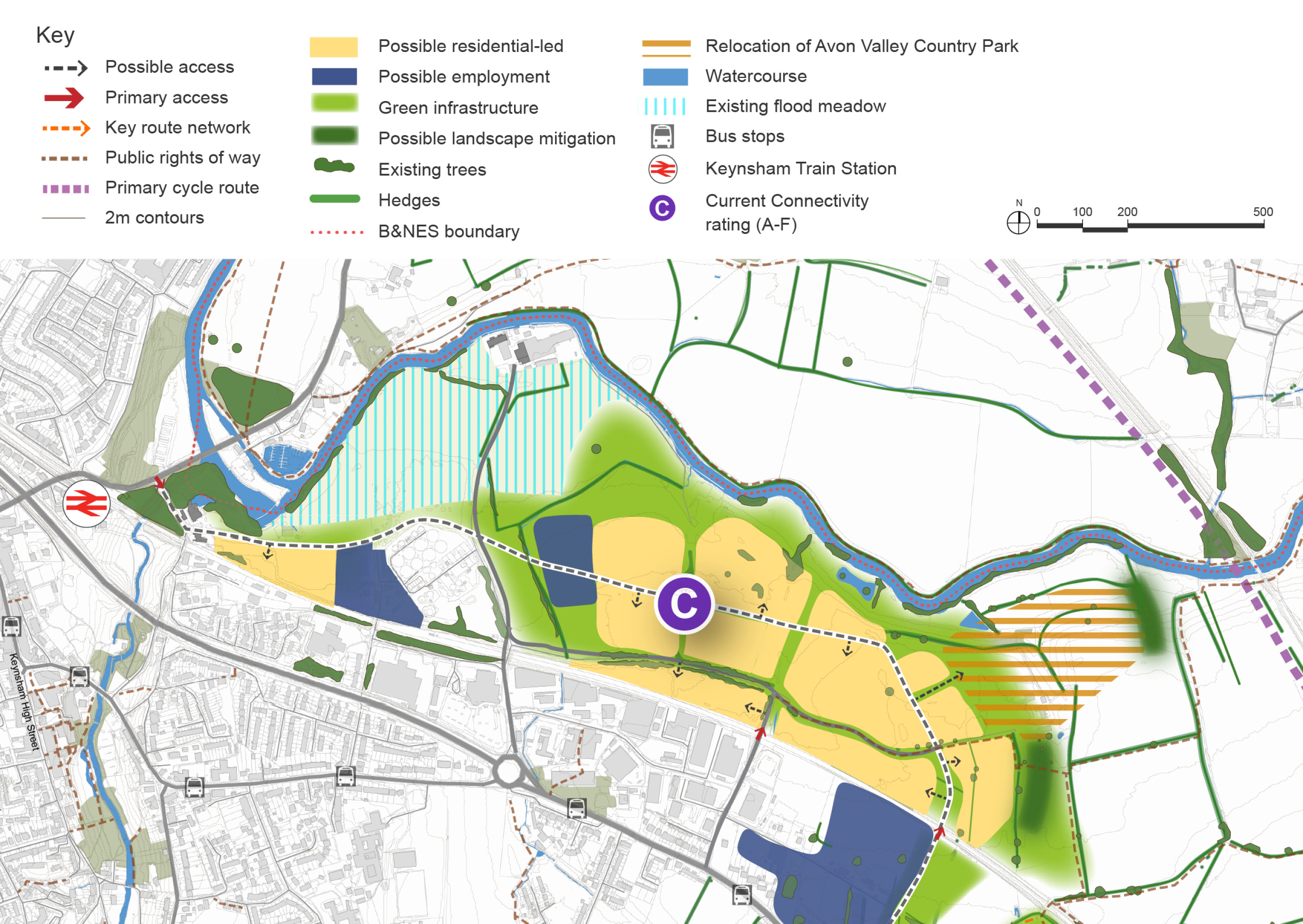
Click to enlarge
North Keynsham Site Option – Key information
| Element | Description |
| Development opportunities |
|
| Constraints |
|
| Mitigation |
|
| DfT current connectivity rating |
|
| Further evidence required |
|