North Radstock Site Option
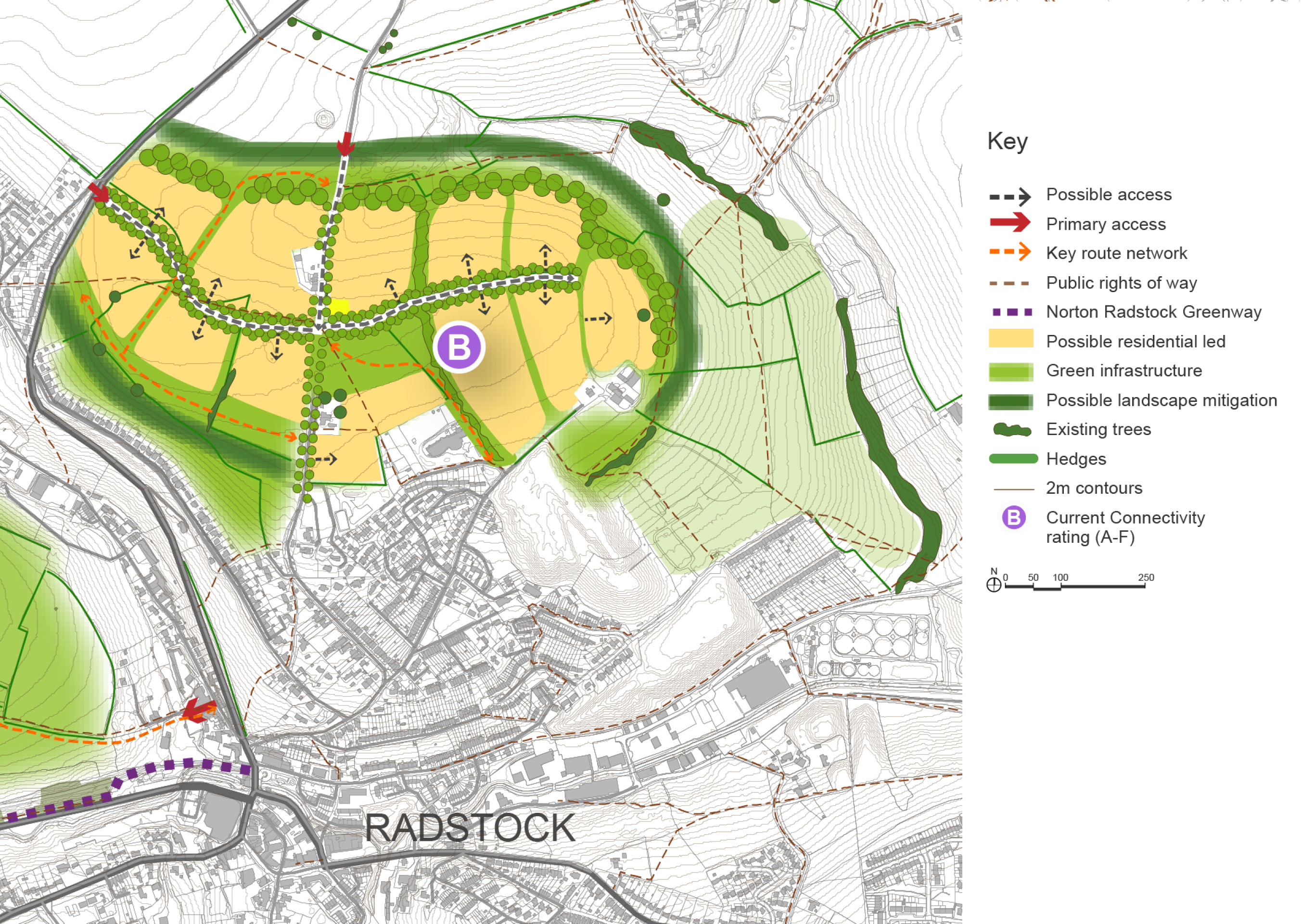
Land immediately to the north of Radstock currently consists of agricultural fields, mostly on the plateau above the town. Bath Old Road, a historic route, runs through the area of search and has a few homes dotted along it. Trinity Church School (primary) sits at the southern edge with access to Woodborough Lane. The area is close to Radstock town centre in the south and is bordered by countryside to the north and east. The A367 runs along the western edge of the area of search with the small settlement of Clandown immediately beyond.
Landscape character is an important attribute in this area given that it sits above the rest of the town and forms part of the green setting of Radstock and the Conservation Area. The landscape and visual impacts of any new development would therefore need to be minimised and mitigated by integrating new development within a robust landscape planting framework and ensuring it blends in with the existing hillside that continue to provide a green setting for Radstock.
A single Scheduled Ancient Monument lies to the north-west of the area, comprising Camerton Romano-British town and associated prehistoric and early medieval monuments. As a consequence of the close proximity to the Scheduled Monument there is some potential for previously unrecorded remains to be present within the area of search, although the part of the area closest to the Scheduled Ancient Monument was subject to landfill and any former archaeological remains would have been removed. There is no record of any remains having been reported during those works.
Bath Old Road appears to be used as a ‘cut through’ and speed is only limited in the built up areas to the south. There is currently no pavement access to and through parts of the area. Existing walking, cycling and wheeling connections into the town centre and to Trinity Church School are poor. Any new development would require and could deliver significant improvements to these connections.
Works to Bath Old Road to provide a Quiet Lane could help to facilitate active travel. The speed limit would need to be reduced and a new pavement provided giving better pedestrian access into the town centre. New vehicular access onto the A367 would be needed so that any development is not accessed solely from Bath Old Road and to ensure there is direct access to nearby bus stops.
The site option presented below could provide up to 1,250 to 1,550 new homes in total, as well as supporting facilities and green infrastructure. The site options have the potential to create a new neighbourhood with a connection to the A367 and direct access to Radstock town centre via the Bath Old Road. It is a residential and landscape led development with green screening to the north and south and a tree-lined street running through the middle of the development creating a sense of place when arriving at the new neighbourhood and contributing to the landscape setting.
Development can also incorporate small scale economic uses that are compatible with a residential area.
Other green links to the countryside will run north-south through the development to create biodiversity links, support habitat improvement, provide views to the countryside and improve the connectivity within the neighbourhood.
The proximity of the development to Radstock town centre will benefit the regeneration strategy for the town centre and should help to increase footfall. Creating a critical mass of residents with easy access to current and new facilities would help the town centre to thrive. The town centre’s regeneration will benefit from future public realm improvements focussing on pedestrian safety and accessibility.
The development will extend to the west and east of the Bath Old Road, with a direct link to Radstock town centre along both the existing Public Rights of Way and routes through the new development. Development is stepped away from the Bath Old Road to preserve its characteristic far-reaching views towards Radstock to the south and open countryside to the north.
Vehicle access to the development areas can be provided to connect onto the A367. Bath Old Road could become emergency access only, and will be a key active travel link between the development and Radstock Town Centre, and north to Peasedown St John.
A greater quantum of development would allow for additional facilities such as a local centre. Wide tree belts around the development area along with a strong boulevard of trees through the centre, should be strategically placed to provide screening to mitigate the visual impacts of this prominent development from long views to the north, east, and south-west. There is a strategic green infrastructure opportunity on the slopes to the east of the site and work is underway to assess the opportunities for strategic green infrastructure, nature recovery and climate resilience.
Whilst the A367 is not currently an Air Quality Management Area (AQMA), it is the main road into Radstock and therefore care must be taken if a larger quantum of development is provided to ensure that this does not result in harm to air quality.
North Radstock – Indicative plan
Click to enlarge
North Radstock Site Option – Key information
| Element | Description |
| Development opportunities |
|
| Constraints |
|
| Mitigation |
|
| DfT current connectivity rating |
|
| Further evidence required |
|