South Peasedown Site Option
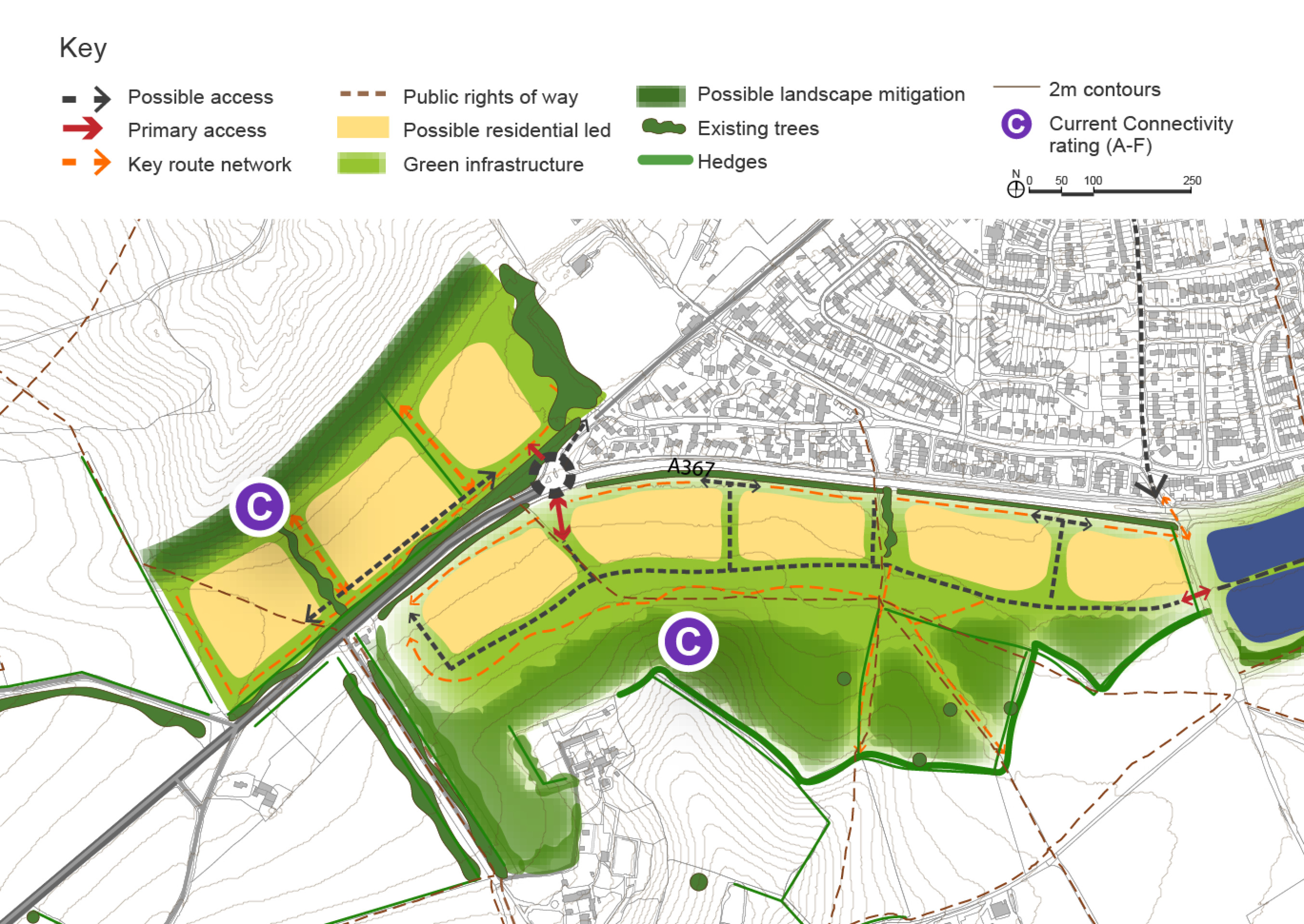
The area to the south west of Peasedown St John comprises three fields aligned along the northern side of the A367. While this parcel projects beyond the current boundary of the settlement, it is well connected to the existing urban area and there are clear opportunities to create better connections, particularly in terms of active travel. The land is nestled adjacent to an ancient woodland as well as having a well treed road frontage with hedgerows that reduce intervisibility with other parts of the wider landscape. All of these features and especially the ancient woodland are vulnerable to damage or loss from new development.
The area has the potential to be developed for residential uses providing an estimated 250 – 300 homes, together with landscape and habitat enhancement/creation. There is also scope for the creation of new public transport and active travel connections back into the village and towards key destinations such as the village centre, the church and primary school.
The area south of Peasedown St John bypass is open arable fields which were historically part of a local estate and includes parkland trees. There are several Public Rights of Way leading out into the countryside, originating in the village centre of Peasedown St John and extending out through the area to the south of the A367, which forms a hard, southern edge to the village. The existing buildings on the southern side of the village turn their backs to the A367. The parcels on the southern side of the A367 are on a skyline which slopes gently towards the south and is clearly visible in medium- and long-distance views across the valley.
In the previous options document the land to the south of the bypass was proposed as an option that could be developed for renewable energy. In light of the local plan reset and substantially increased housing requirement the site has been reviewed and identified as a potential option for housing. It would have capacity for an estimated 550-700 homes. Given the high landscape value of the site any development would need to include extensive green infrastructure to integrate into the surrounding landscape. Public rights of way would need to be protected and walking recreational routes provided.
The site is also severed from the village by the existing bypass. To facilitate development the nature of the bypass would need to be substantially altered for example through the provision of crossing points, slower traffic speeds and for development to address the street scene. Pedestrian access to the village centre is required. There may be potential for additional retail provision.
Previous engagement as part of the Somer Valley Links project had proposed a roundabout on the south junction of the A367 and Bath Road to improve access to the village. The provision of the roundabout may be required to facilitate development at the proposed location.
South Peasedown – Indicative plan
Click to enlarge
South Peasedown Site Option – Key information
| Element | Description |
| Development opportunities |
|
| Constraints |
|
| Mitigation |
|
| DfT current connectivity rating |
|
| Further evidence required |
|