Timsbury Site Options
Timsbury is one of the largest villages in the district and a hub for the local communities. The Site Options for Timsbury are being presented together and include Emlett Field, Lippatt and Croscombe Lanes and the existing site allocation East of St Mary’s School. The sites collectively have the potential to deliver 210 – 380 new homes for the area.
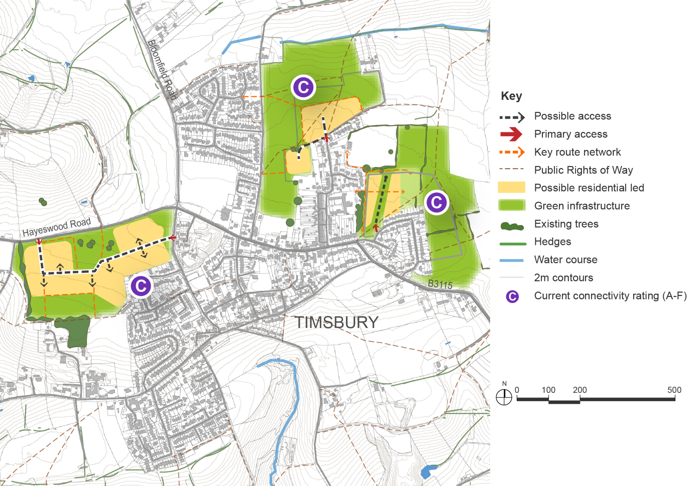
Timsbury is one of the larger and more sustainable villages in the district, located to the south-west of Bath. It benefits from a broad range of services and facilities, including a primary school, local shops, and community amenities. The village has a moderate connectivity score and serves as a local hub for surrounding rural communities.
Known infrastructure constraints in the village include limited GP provision and a cemetery that is nearing capacity. There are also longstanding transport issues associated with North Road, which would need to be addressed as part of any future growth strategy.
Timsbury was previously allocated a site to the east of St Mary’s School in the Placemaking Plan. However, this allocation has not yet come forward for development and remains a live option. The site is currently allocated for approximately 20 homes, but evidence suggests it could potentially be expanded to accommodate a total of between 50–70 homes. In light of changes to housing targets, it is appropriate to test an increase in the number of homes on the allocated site, subject to the protection of important views and landscape character.
In addition to the existing allocation to the east of the village, a new site to the west of Timsbury has been promoted known locally as Emlett Field, Hayswood Road and is presented for consultation. This site is well-related to the existing built form and offers the opportunity to test the potential for larger-scale growth in the village. The site has the capacity accommodate between 160-220 homes, however it has been promoted for up to 120 homes.
Central to the village, a site between Lippiatt Lane and Crocombe Lane has been put forward following discussions with the parish council. The lower parcel is proposed to remain largely as green space, while land off Crocombe Lane is identified as a potential option for housing development. The site could accommodate 70–90 homes; however, the impact on North Road would need to be investigated and resolved as part of any plans to develop these sites. Improvements would also be required to the access on Lippiatt Lane and Crocombe Lane/Lansdown View to ensure sufficient capacity for the additional traffic generated. This may reduce the number of homes that would be sustainable in this location, noting also that the village primary school is on Lansdown View.
Together, the identified sites provide a basis for considering a more comprehensive approach to growth in Timsbury. This could support the delivery of new housing, infrastructure improvements, and enhanced connectivity, while helping to address local service pressures. This level of growth would exceed the 5% baseline but it is considered appropriate to test options, given the opportunity to deliver wider benefits. It should be noted that not all site options may be taken forward; the final approach could involve a combination of sites, or a reduced scale of development, depending on infrastructure capacity, environmental constraints, and the outcomes of further assessment and consultation. In preparing the Draft Local Plan, opportunities to provide additional cemetery space and explore potential solutions to GP capacity issues will also be considered, reflecting local infrastructure needs identified through engagement with the parish council and stakeholders.
Any development would need to be carefully designed to respect the village’s landscape setting, respond to infrastructure capacity constraints and mitigate impacts on the conservation area. Access limitations to some sites will also need to be considered particularly those from North Road to the centre of the village which suffers from known transport issues.
Connectivity scores shown in the site options plan below are based on the Department for Transport’s A–J grading, where A is the highest within B&NES.
Timsbury Site Options – Indicative plan
Click to enlarge
Timsbury Site Options – Key information
| Element | Description |
| Development opportunities | Emlett Field (left of plan)
|
| Constraints |
|
| Mitigation |
|
| DfT current connectivity rating |
|
| Further evidence required |
|