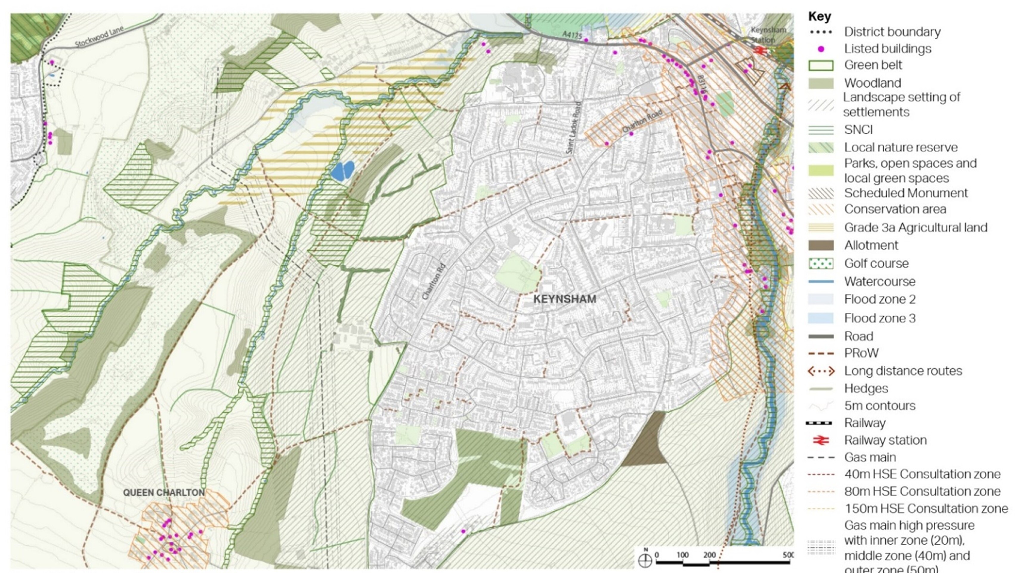
West Keynsham Site Options
West Keynsham comprises two sites, West Keynsham North and West Keynsham South, which are being presented together. Options are being consider for both sites, each with the capacity to accommodate 300 – 400 homes.
Currently located in the Green Belt, further assessment is required before the sites can be released. There are also many other constraints that would need to be resolved through a range of mitigations to make the development of the sites acceptable in planning terms.
West Keynsham is located to the west of Charlton Road. In light of the increased housing need for the district and the amended national planning policy context for Green Belt, the two West Keynsham sites consulted on in the 2024 Options consultation have now been expanded further in this Options Reset consultation. The previous two options have been expanded northwards and southwards respectively, such that the entire western edge of Keynsham is now covered by an option.
The southern end of the site directly fronts Charlton Road, whereas the northern side neighbours the back gardens of the houses on Lays Drive. The land is mainly used as arable fields with Lays Farm Trading Estate located in the centre. The site is fragmented by well-maintained hedgerows and mature trees creating enclosed areas. To the west of the site, the land slopes steeply towards Stockwood Vale.
Two options for West Keynsham are set out below. It is important that local employment uses are retained in this area. The first option optimises housing development , but would potentially require the relocation of businesses at Lays Farm Trading Estate within the site, retaining the overall quantum of employment floorspace. The second reduces the number of homes proposed significantly, retaining Lays Farm Trading Estate in situ.
The sites are located in the Green Belt. Any release from the Green Belt and subsequent allocation for development will need to demonstrate exceptional circumstances. To understand and consider the impact of potential development on the Green Belt an assessment of the extent to which different parcels of land serve the five purposes is being undertaken. The emerging Stage 1 Strategic Green Belt Assessment being carried out by WECA will assess the site for its contribution towards meeting the five Green Belt purposes and also provide a provisional indication as to whether it meets the definition of grey belt set out in the NPPF and updated Planning Practice Guidance, which is sequentially preferable to greenfield Green Belt in national policy. The assessment work is ongoing and will inform the Draft Local Plan. It is likely that following the Stage 1 Strategic Green Belt Assessment a more detailed (stage 2) assessment of the impact of development on more specific areas of the Green Belt will also be required.
Strategic development on the west and south western edges of Keynsham could provide significant benefits. This part of the town (especially the south western extremity) is not well served by either community facilities or walking, cycling or wheeling access to the town centre. Planned and co-ordinated development could provide opportunities to substantially improve sustainable transport links northwards along Charlton Road and eastwards from the Parkhouse Lane area into the town centre, as well as opportunities to provide improved community facilities in this part of Keynsham. Recent housing development has meant Keynsham has grown significantly without supporting infrastructure. Additional development can help improve this part of the town as a community well linked into the rest of the town and town centre.
West Keynsham context plan
Click to enlarge
West Keynsham (north) Site Option – Indicative plan
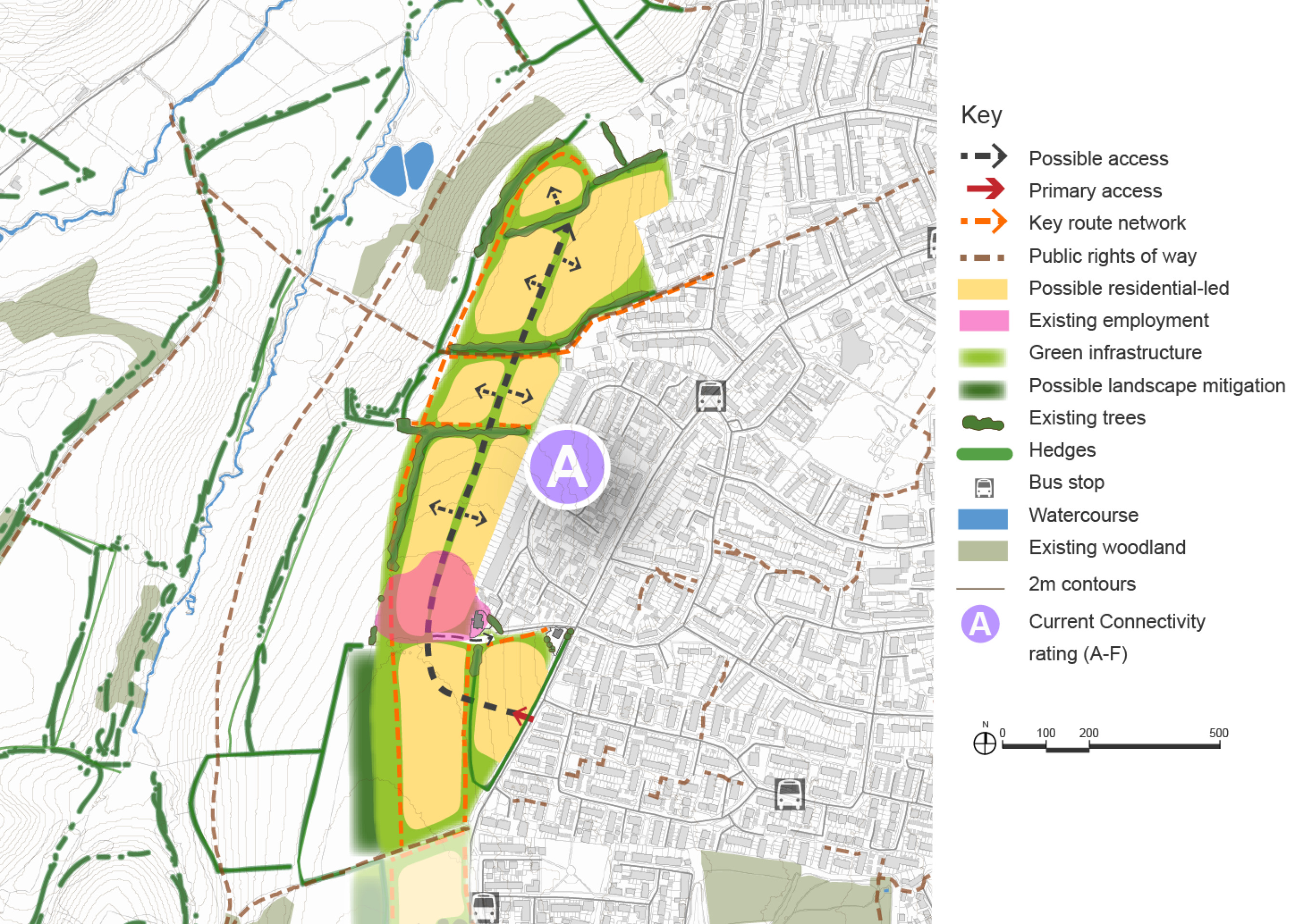
Click to enlarge
West Keynsham (south) Site Option – Indicative plan
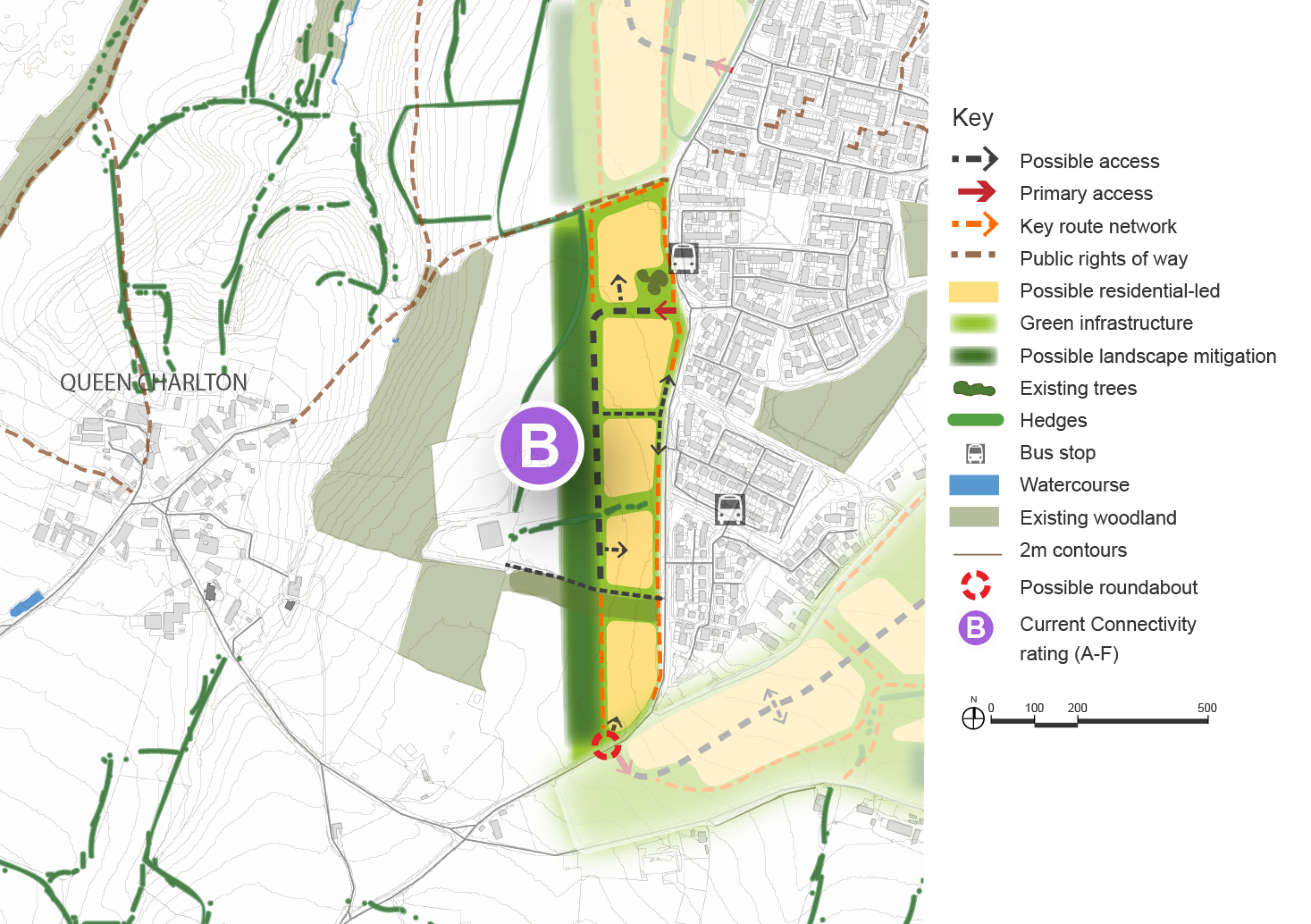
Click to enlarge
West Keynsham Site Options (north and south) – Key information
| Element | Description |
|
| North | South | |
| Development opportunities |
|
|
| Constraints |
|
|
| Mitigation |
|
|
| DfT current connectivity rating |
|
|
| Further evidence required |
|
|