West of Bath Site Options
One of the locational options that is being considered to help address the development needs of Bath is land to the west of the city. This area has potential to provide housing that is more affordable, new office or industrial buildings, or potentially to relocate the existing Newbridge Park and Ride, thereby freeing up the existing site for other forms of development.
Development should be exemplary with regards to its sustainability and quality, with an efficient use of land, and excellent connections to public transport and active travel which complement the council’s aspirations for high quality placemaking. It would be of higher density, include a broad mix of residential tenures, with supporting social infrastructure and access to natural green and blue spaces.
Development would deliver public benefits and help to address objectively assessed housing and other economic needs, but this has to be weighed against the substantial harm that all the options will cause to the World Heritage Sites and impacts on the setting of the Cotswolds National Landscape. To progress development through the Draft Local Plan we would need to demonstrate that the public benefits outweigh the substantial harm.
Whilst development to the West of Bath would have public benefits particularly in terms of providing needed housing and additional employment space, a Landscape and Historic Environment assessment of a range of development typologies in land to the west and south of Bath has been undertaken.
The assessment says development is likely to cause substantial harm to the World Heritage Sites (particularly to the attribute of the ‘green setting of the city in the hollow in the hills’) and that this harm cannot be satisfactorily mitigated. It would also cause harm to the setting of the Cotswolds National Landscape.
The NPPF makes it clear that substantial harm to the WHSs should be ‘wholly exceptional’. In addition, the NPPF makes it clear that protection and enhancement of a heritage asset should be given great weight and that as a WHS is the most significant asset, it should be given the greatest weight.
Given the technical assessment undertaken and the national policy context it is clear that development West of Bath would face a very high bar and would need to demonstrate substantial public benefits to be included in the Draft Local Plan. Further work will be necessary on the form development might take and to identify the public benefits and harms. This site is included within this Local Plan Options Document to test and ascertain whether public benefits can be identified that would outweigh the harm.
Map of West of Bath – from the Assessment of Potential Impact
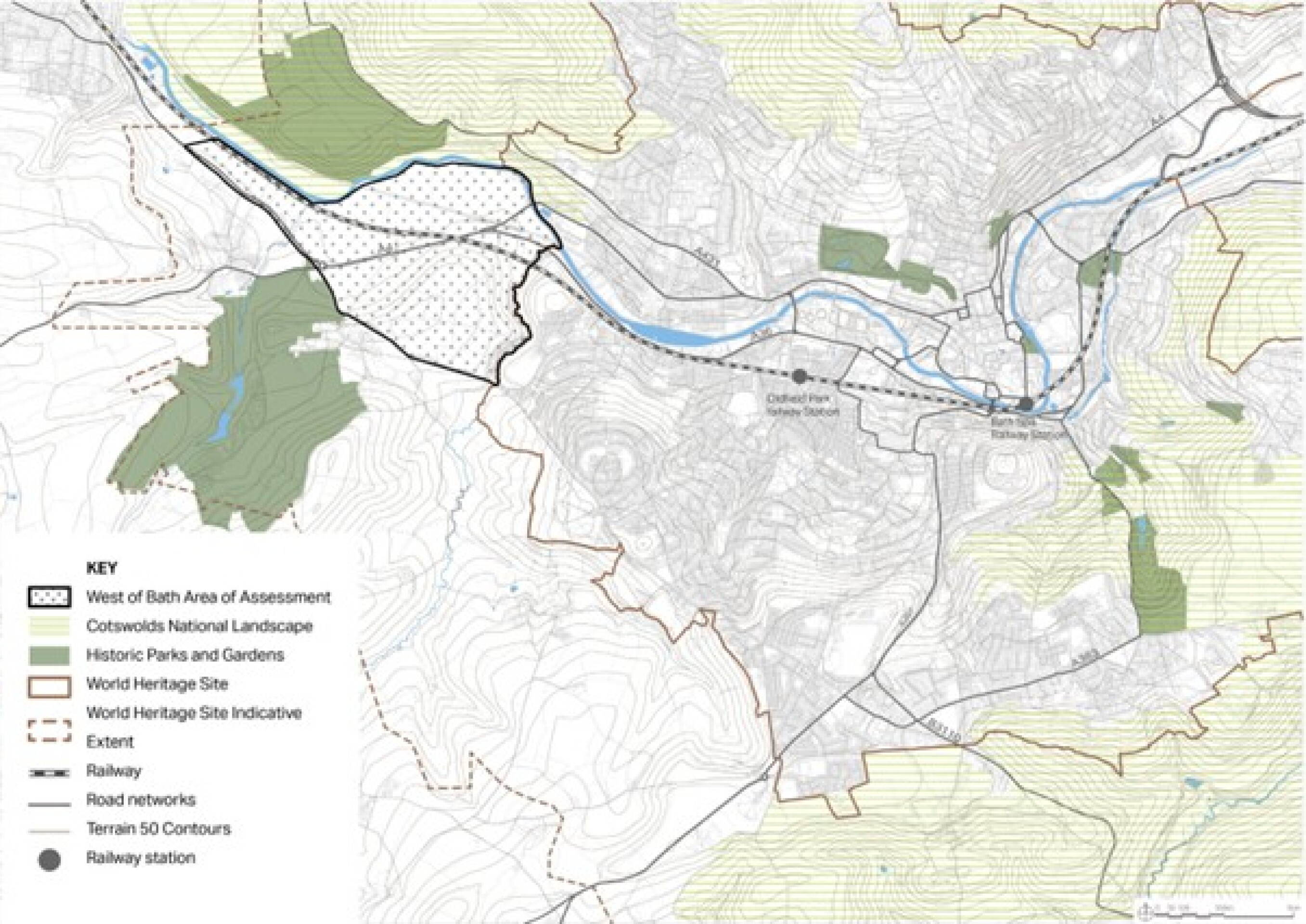
Click to enlarge
In addition to identifying whether substantial public benefit of development would outweigh harm to the WHS and its setting, this location also lies within one of the most important areas of the Green Belt and the impact of development on the Green Belt would need to be carefully considered within the context of revised national policy. In order to allocate land in this location for development it would need to be removed from the Green Belt.
Exceptional circumstances would need to be demonstrated to justify removing the land from the Green Belt. Whilst such ‘exceptional circumstances’ are site specific this broadly means demonstrating that reasonable alternatives outside the Green Belt have been considered and rejected and that harm to the Green Belt is outweighed by the benefits of development.
In order to consider harm to the Green Belt a Stage 1 Assessment needs to be undertaken to understand the contribution of land parcels to the nationally defined Green Belt purposes. This would then be followed by a Stage 2 assessment to identify impacts of development on the Green Belt in this location greater detail. A Stage 1 Strategic Green Belt Assessment is being undertaken by West of England Mayoral Combined Authority (WECA) and the constituent authorities to assess contribution of land parcels to the national Green Belt purposes and to give a provisional indication of land that might meet the definition of ‘grey belt’.
This is relevant as the revised NPPF makes it clear that land defined as ‘grey belt’ should be considered for release for development, before other greenfield areas of Green Belt. The Strategic Green Belt assessment work will inform the Draft Local Plan.
It should also be noted that if the West of Bath site were to come forward for development and including a primary school then this could open up the potential to consider Corston as a location for further housing led development. At present the village does not benefit from a primary school so an option for development in this location is not currently presented.
West of Bath Option 1 – Indicative plan
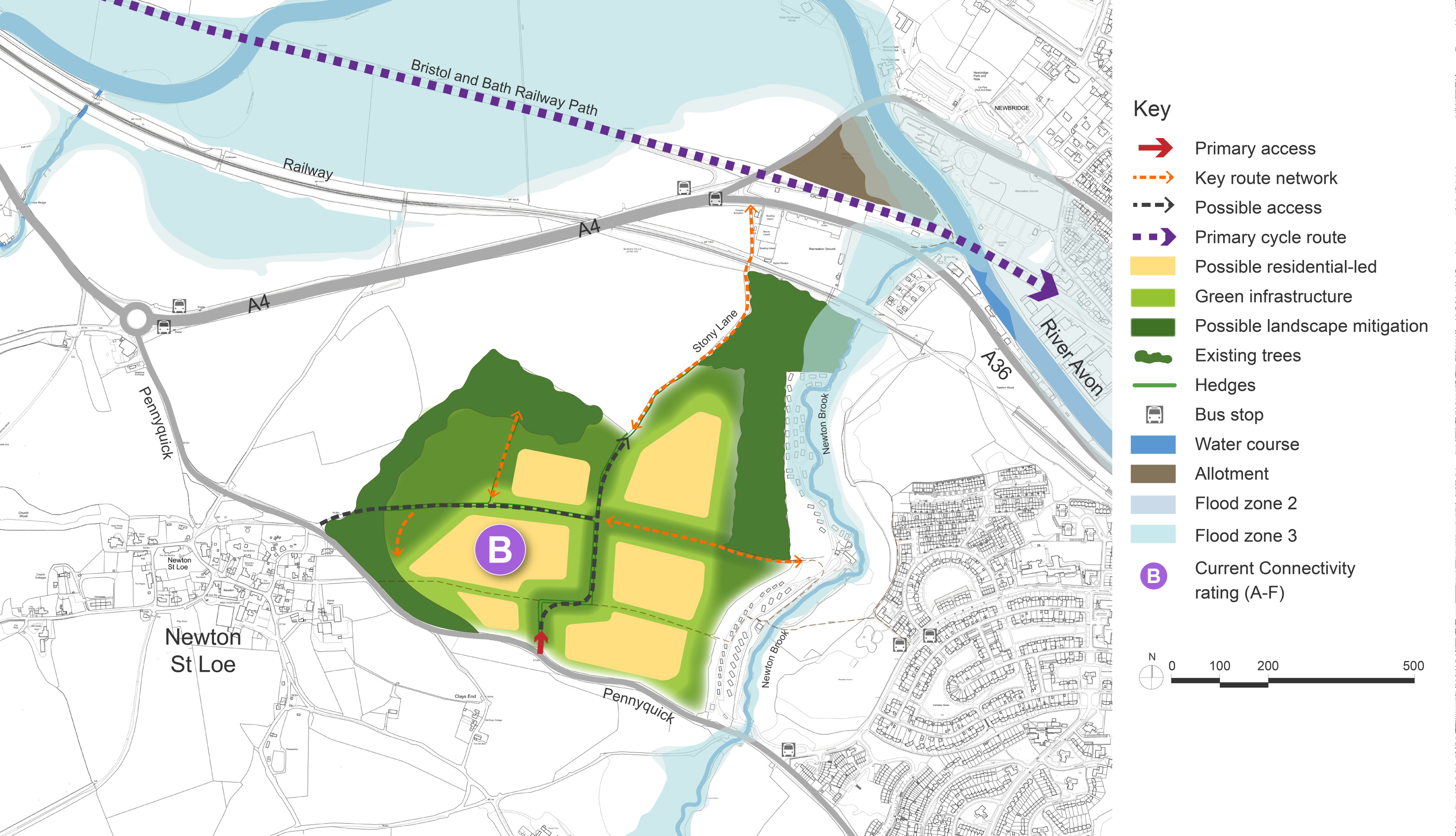
Click to enlarge
West of Bath Option 2 – Indicative plan
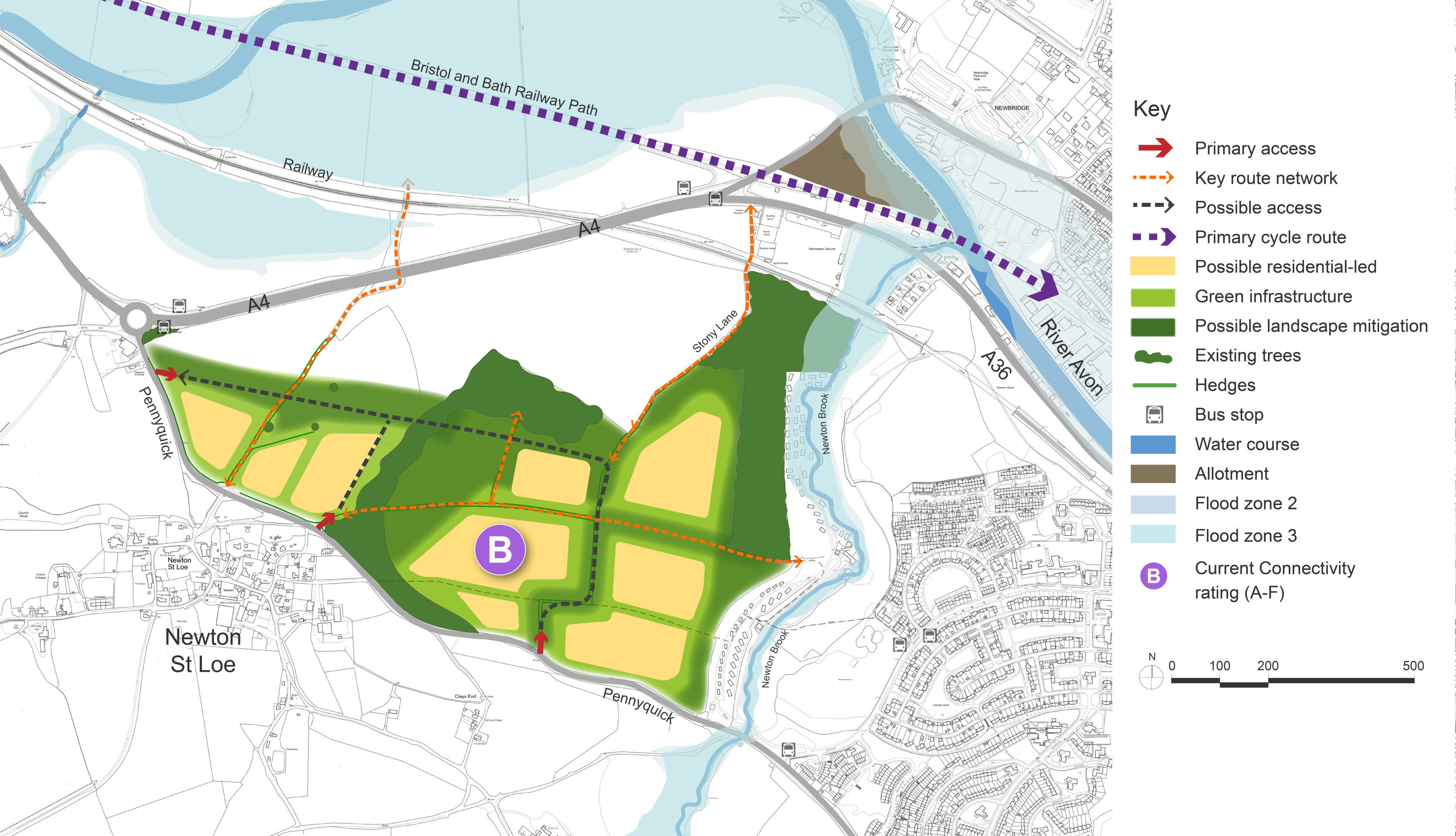
Click to enlarge
West of Bath Option 3 – Indicative plan
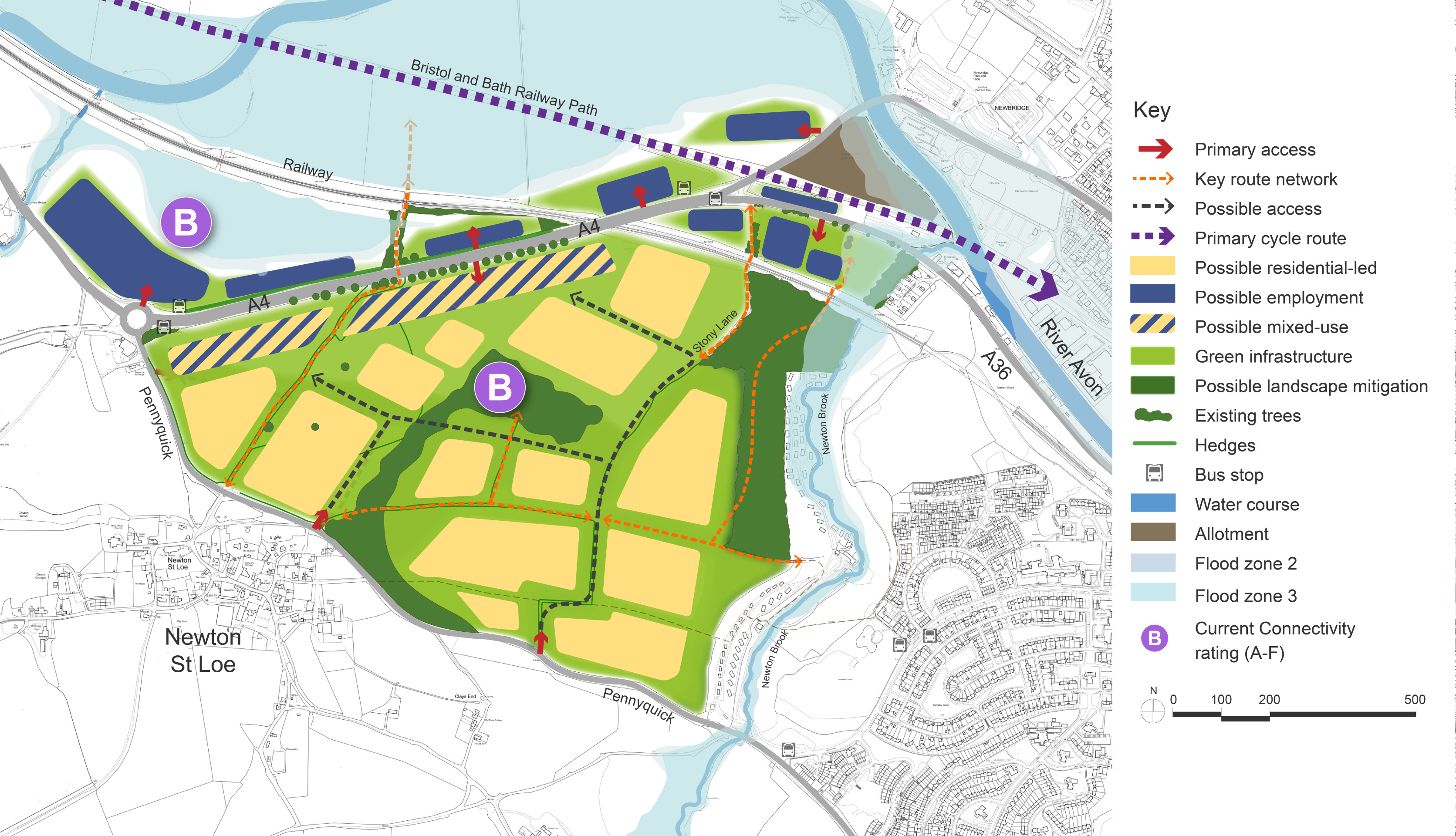
Click to enlarge
West of Bath Site Options – Key information
| Option | Description |
| 1 | Option 1 offers a potential development capacity of between 850 to 1,150 dwellings and the proposal seeks to achieve partial mitigation in relation to the impacts on the Cotswolds National Landscape. |
| 2 | Option 2 provides for a range of about 1,100 to 1,450 homes and would cause greater harm to the setting of the Cotswolds National Landscape than option 1. This scale of development presents the opportunity to provide more social infrastructure such as a primary school and a local shop, which could also benefit the neighbouring communities of Newton St Loe and Corston. |
| 3 | Option 3 optimises the development opportunities within the area, whilst avoiding flood zones and causes greater harm to the setting of the Cotswold National Landscape than options 1 or 2. The benefits of this option are that it could deliver a thriving mixed use community on the western edge of Bath, with a range of around 1,500 to 1,950 homes, a healthy proportion of which would be affordable to help address our pressing housing needs, a new school, and a vibrant district centre. There would be an opportunity for the development of a significant amount of employment floorspace adjacent to the A4 providing a wide range of jobs in innovative sectors. It would be an exemplary development, befitting its sensitive location, with integrated green infrastructure and places for people and nature. It will be connected into Bath and the wider region with high quality public transport and active travel routes. |