West Saltford Site Options
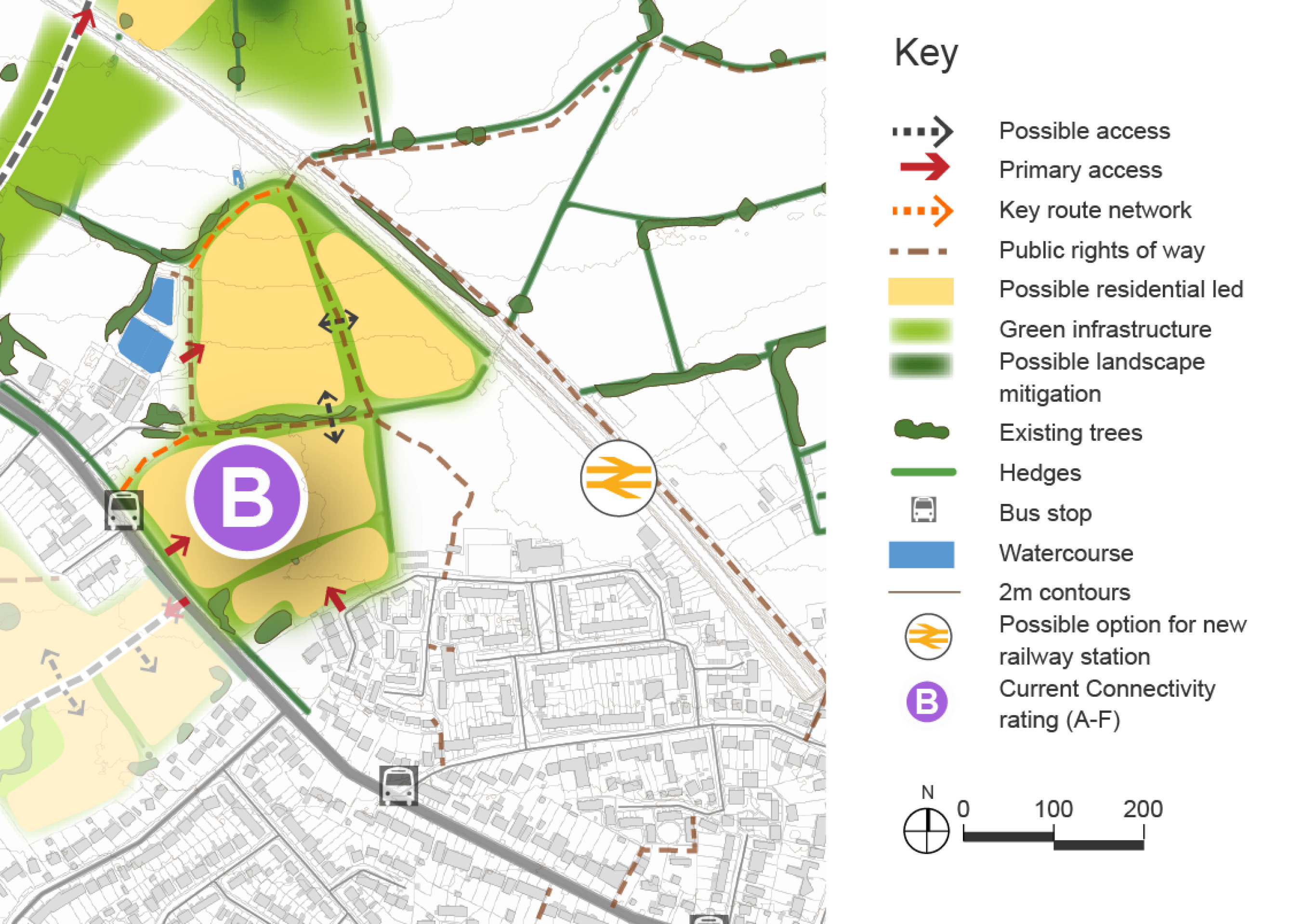
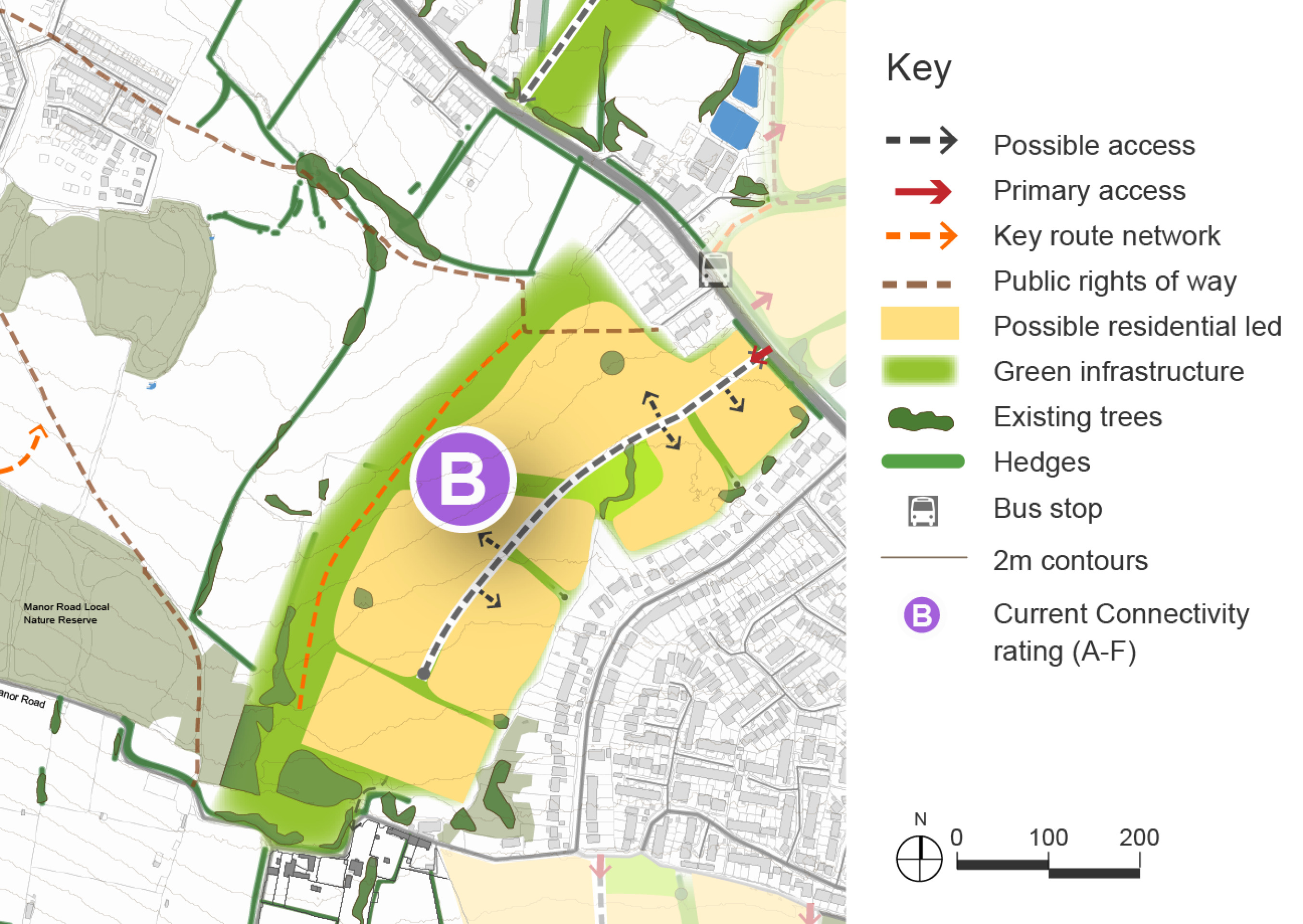
West Saltford comprises two sites on western edge of the village, which are being presented together. The site north of the A4 has the potential to deliver 300 – 350 new homes. The site south of the A4 has capacity of 650-800 new homes and was considered as part of the 2024 Option consultation. If delivered alongside other sites within the village there is the opporutny to deliver a new primary school on this site.
Currently located in the Green Belt, further assessment is required before the sites can be released. There are also many other constraints that would need to be resolved through a range of mitigations to make the development of the sites acceptable in planning terms.
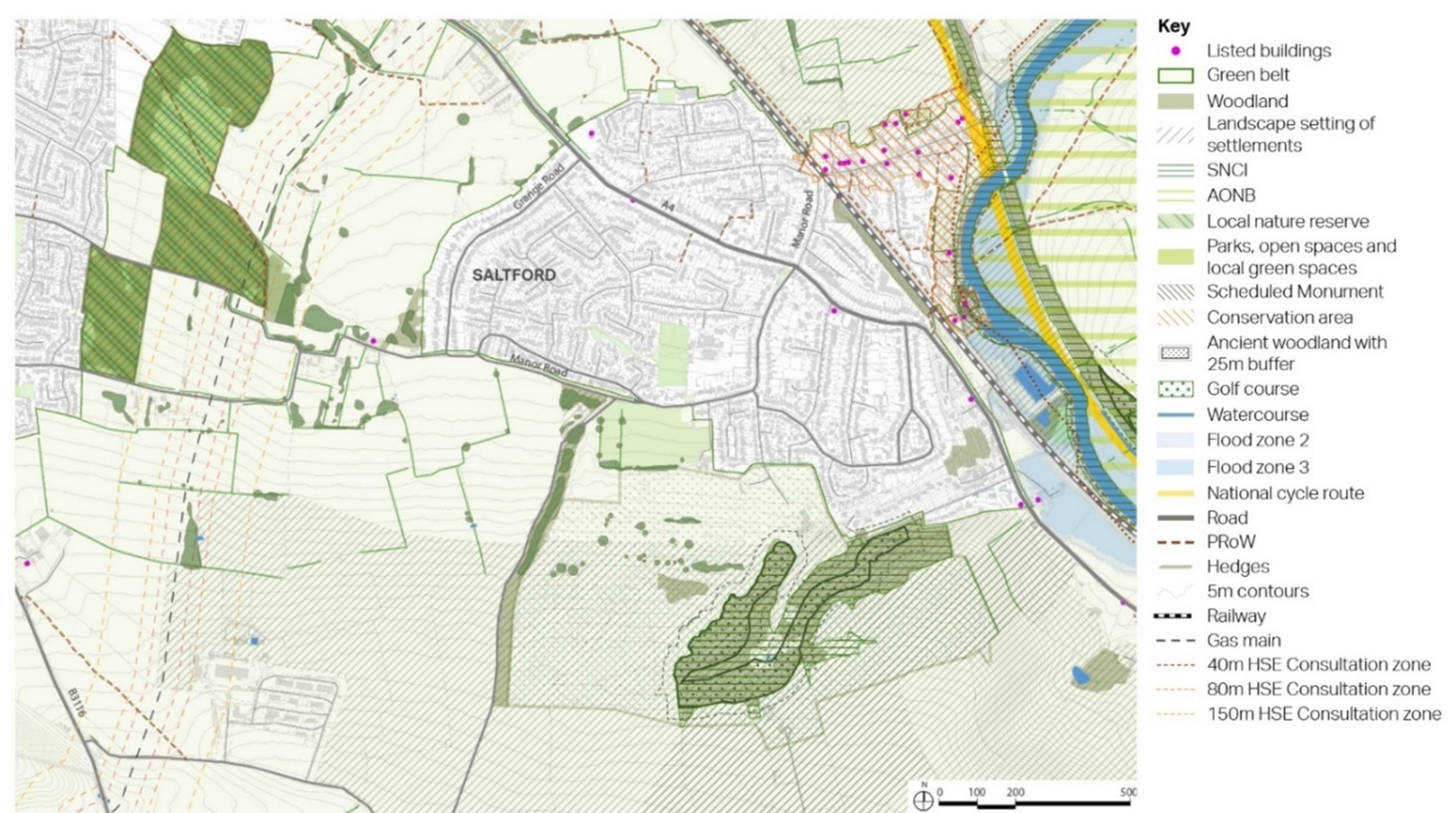
West Saltford is located on the western edge of the village of Saltford Village. The area is mostly flat arable fields with some hedgerows containing hedgerow trees.
Two site options for development are under consideration at West Saltford, one to the north of the A4 and one to the south. The sites both connect directly onto the A4 corridor, providing good access to frequent bus stops providing services into Bath and Bristol. The site to the north of the A4 is a new site in this Options consultation and was not previously presented in the spring 2024 options consultation. It is potentially in proximity to a new train station at Saltford Village, with land to the north west of Saltford one of two locations being considered for a potential rail station through feasibility work being undertaken by WECA and Network Rail.
The land parcel south of the A4 is located to the west of Grange Road in Saltford Village. However, no permeability currently exists between Grange Road and the parcels, due to the continuous configuration of dwelling plots along the road. As such, walking and cycling routes into the village would need to be provided from the south side of the site, connecting to Manor Road, and to the north along the A4, though there may be scope, through discussions with local landowners, to provide a walking route through an existing.
A key priority for the Keynsham and Saltford Village area of the district is to retain a significant green gap between the two settlements. As such, any development located to the west of Saltford Village will need to be carefully assessed in conjunction with the options at North Keynsham (see page 94) and South East Keynsham (see page 113), as well as in relation to land already allocated to the east of Keynsham. Development will need to include requirements to strengthen and enhance the remaining green infrastructure between Keynsham and Saltford, seeking to make it more accessible and useable.
The sites are located in the Green Belt. Any release from the Green Belt and subsequent allocation for development will need to demonstrate exceptional circumstances. To understand and consider the impact of potential development on the Green Belt an assessment of the extent to which different parcels of land serve the five purposes is being undertaken. The emerging Stage 1 Strategic Green Belt Assessment being carried out by WECA will assess the site for its contribution towards meeting the five Green Belt purposes and also whether it meets the definition of grey belt set out in the NPPF and updated Planning Practice Guidance, which is sequentially preferable to greenfield Green Belt in national policy. The assessment work is ongoing and will inform the Draft Local Plan. It is likely that following the Stage 1 Strategic Green Belt Assessment a more detailed (stage 2) assessment of the impact of development on more specific areas of the Green Belt will also be required.
West Saltford context plan
Click to enlarge
West Saltford North of A4 Site Option – Indicative plan
Click to enlarge
West Saltford South of A4 Site Option – Indicative plan
Click to enlarge
Site Option – Key information
| Element |
Description |
|
| North of A4 | South of A4 | |
| Development opportunities |
|
|
| Constraints |
|
|
| Mitigation |
|
|
| DfT current connectivity rating |
|
|
| Further evidence required |
|
|