Westfield - context
The parish has a rich history with heritage from its Roman settlement and later mining industry. Coal mining was established in the area in 1763 and became a significant industry in Westfield until the closure of the mines in the mid-late 20th century. Up until the early 19th century Westfield remained a predominantly rural area.
Development and infrastructure grew in the parish alongside its coal industry during the 19th and 20th centuries and the terraced Miners’ Cottages, built to accommodate local workers, defined the street scene. During the late 20th century, following the closure of the coal industry, residential development utilised the brownfield sites with several residential cul-de-sac estates being built in this period. Other industries were also established, primarily at Westfield Industrial Estate to the southern end of the parish.
In recent years new housing development has been permitted to the south of Westfield on the other side of the border in Somerset. The majority of Radstock Town centre sits within the Radstock boundary and therefore Westfield currently lacks a local centre of its own.
There is a primary school, Fosse Way School and Bath College Somer Valley Campus.
There are two important green corridors within Westfield comprising Waterside Valley and the green land which borders the cycleway in the north which provide valuable recreational space and long-distance views into surrounding rural landscape.
- There is a strong network of public rights of way and connections to the cycle path. Local residents would like to see access to the countryside improved.
- Public transport has been reduced in the Somer Valley with some areas having very limited access to bus services.
- The town is surrounded by green hillsides which are integral to its landscape character.
- The town’s mining heritage has shaped its landscape character.
- Westfield does not have its own local centre
- Housing development has been permitted to the south of Westfield within Somerset impacting on local services
- Provide homes to meet the needs of the local area, including provision of homes that are affordable.
- New development should complement relevant elements of the Somer Valley Rediscovered Project to provide greater opportunities for people to engage with and enable nature recovery.
- New development should provide a greater choice of transport via sustainable and active travel (walking, cycling, wheeling and public transport). New development can link into the existing public transport network allowing for buses to become more viable.
- Ensure built and natural environments promote health and wellbeing for all.
Expansion of the Industrial Estate has the potential provide the maximum floorspace of the following uses should only one use class come forward. A mix of uses would result in a lesser amount of floorspace for each use.
- Industrial – 48,240 square metres
- Office – 96,480 square metres
- Warehouse – 60,300 square metres
Within the previous consultation the site was also considered as a housing site. It sits adjacent to the existing Westfield industrial estate. There is currently no pavement access to the main road and the site accommodates an existing stream that flows into the waterside valley. The land could accommodate around 200 homes.
Westfield Industrial Estate East Option 1 (Economic Use) – Indicative plan
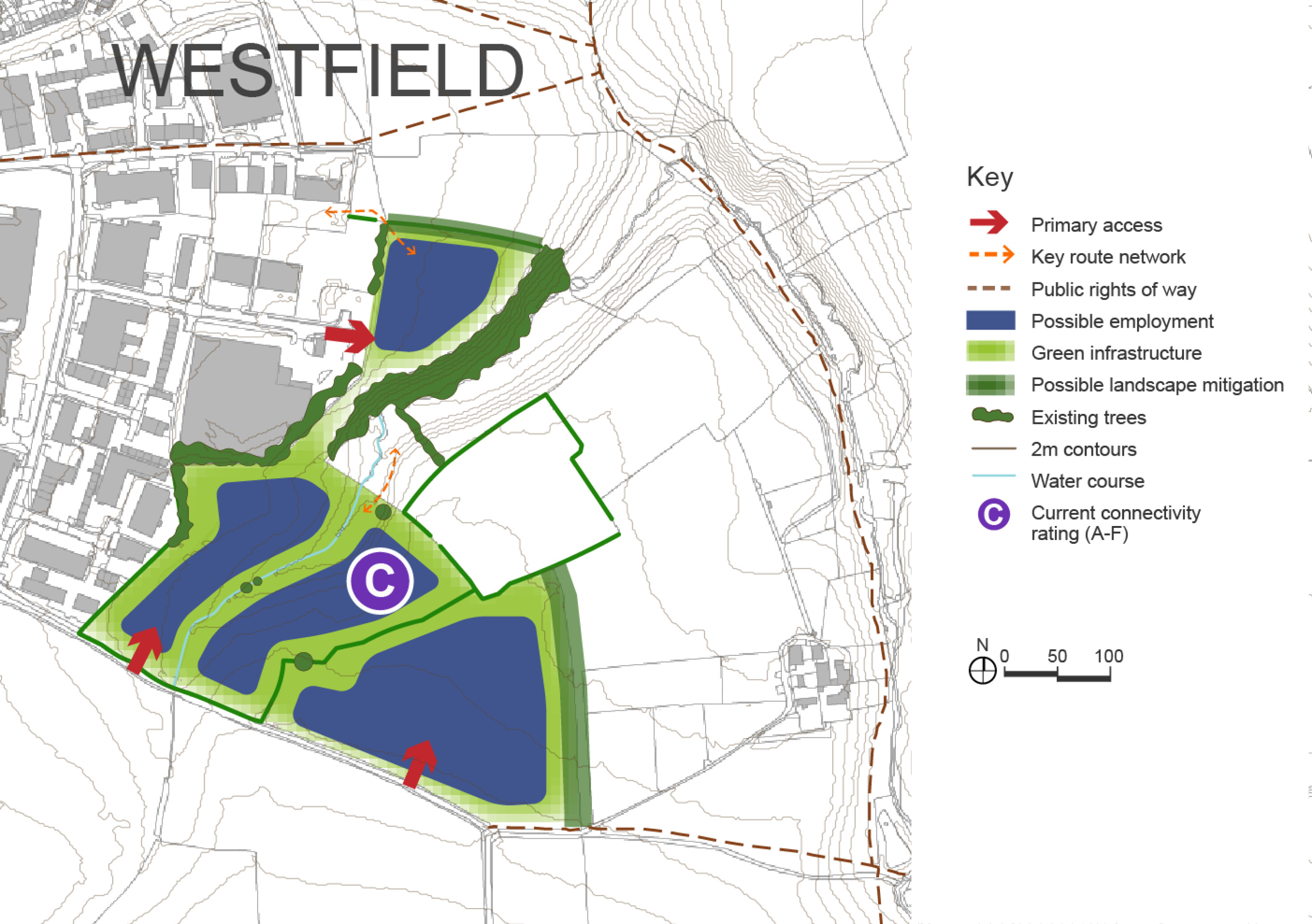
Click to enlarge
Westfield Industrial Estate East Option 2 (Housing) – Indicative plan
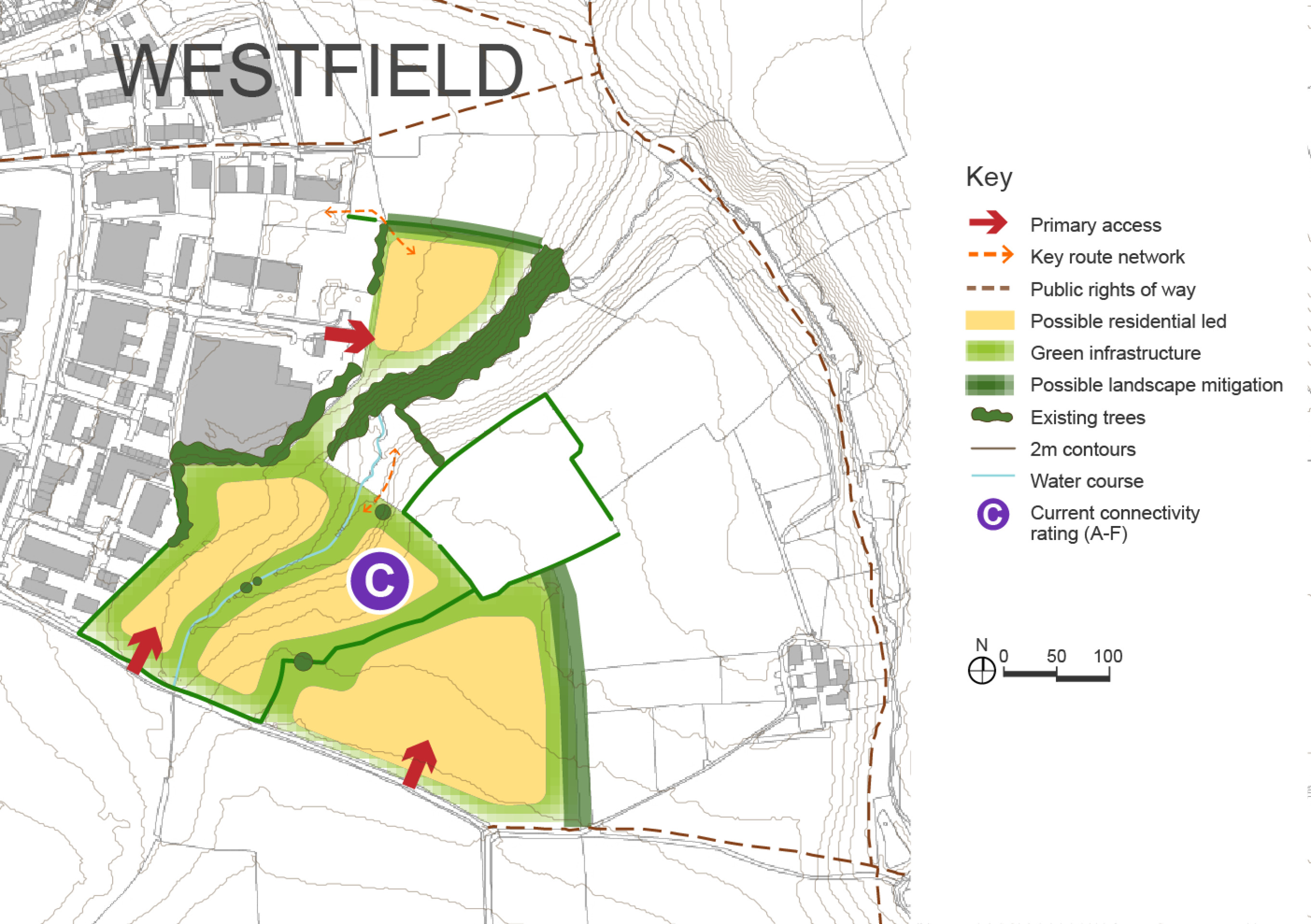
Click to enlarge
Westfield Industrial Estate East Site Options – Key information
| Element |
Description |
|
| Option 1 – Economic use | Option 2 – Housing | |
| Development opportunities |
|
|
| Constraints |
|
|
| DfT current connectivity rating |
|
|