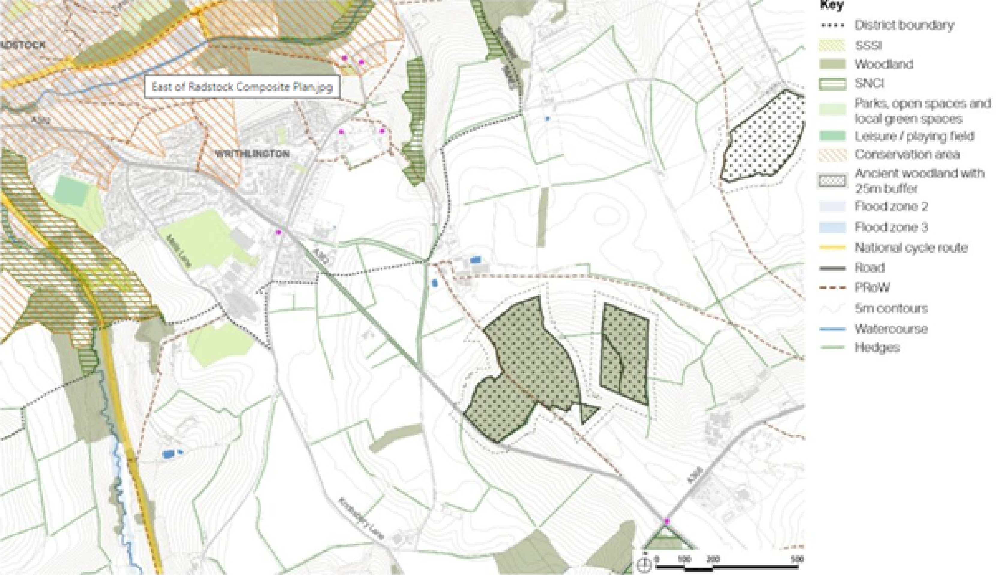
Writhlington Site Option
The area sits within the existing landscape comprising agricultural fields, enclosed by the valley to the northeast, which forms part of the Wellow Brook valley to the north. To the south of the valley, the landform rises to form a shallow plateau, centred along Green Parlour Road.
The A362 runs through the area providing vehicular access to both the northern and southern parts of the locality.
Writhington has one secondary school and one primary school.
New development would generate the need for new and improved links to the town centre and to the surrounding countryside. The existing five-way junction at Frome Road, Old Road and Manor Road is heavily congested. In particular, there are schools and associated traffic either side of the junction. Development would require and could help facilitate improvements to the existing junction, which would provide better access to and within the area also better supporting a local centre. In order to enable development and in addition to improving the existing five-way junction, a new junction would need to be created to relieve pressure on the existing five-way junction. Manor Road is currently used as a ‘cut through’ to access Peasedown St John. Braysdown Lane which connects to Manor Road is proposed to be designated as a quiet lane which may help reduce use of Manor Road by cars.
There are limited public transport connections into the town centre therefore, currently people without a car struggle to access services. The potential to improve public transport connections associated with any development would also need to be explored.
The area is surrounded by gently rolling, open countryside, easily accessible by existing lanes and new and improved connections. Nearby ancient woodlands would be a natural edge to the development and these areas of planting could be expanded by the creation of a buffer zone, which would provide protection for the ancient woodland and improve biodiversity.
The area is located at the edge of a rolling and indented plateau with the steep sided valley of the Wellow Brook immediately to the north. It occupies an elevated position on the skyline. It is therefore important that any development retains a green landscape setting of the wider Writhlington area. The existing network of hedgerows, along field boundaries and roads, would also need to be strengthened and new open spaces created to form a landscape setting for any new development. New landscape planting would be needed to soften the visual impact of development. There are also walking connections of paths and lanes into the countryside and scope for more and improved connections.
Given the topography of the site close attention would need to be paid to the drainage of the site to ensure that development does not cause surface water flooding.
Any future development would need to be on land within both B&NES and Somerset Council administrative areas in order to provide a quantum of development necessary to facilitate provision of shops, services and improvements to the road network. This requires ongoing dialogue between the two councils regarding the potential for future development. If development were to be progressed the two councils would also then need to co-operate on their respective local plans and work together on preparing a placemaking strategy to facilitate creation of a high quality, sustainable and healthy development well connected to the rest of Radstock and the surrounding area.
In addition, the councils would need to liaise on identifying infrastructure requirements and funding arrangements including developer contributions. This will need to be carefully assessed from a school admission perspective as Somerset residents may look at school provision within B&NES.
The area has the potential to support a reasonably large scale residential-led development, which would also deliver open space, social infrastructure, nature recovery and improved local facilities over the Plan period. Development of this scale and in this location would also support regeneration efforts in the local town centres.
Writhlington context plan
Click to enlarge
Development in this location could provide up to 950 to 1,150 homes. If the site is to be developed then the quantum of the development must be viable to allow for and help deliver junction improvements along the A362.
Development can also incorporate small scale economic uses that are compatible with a residential area.
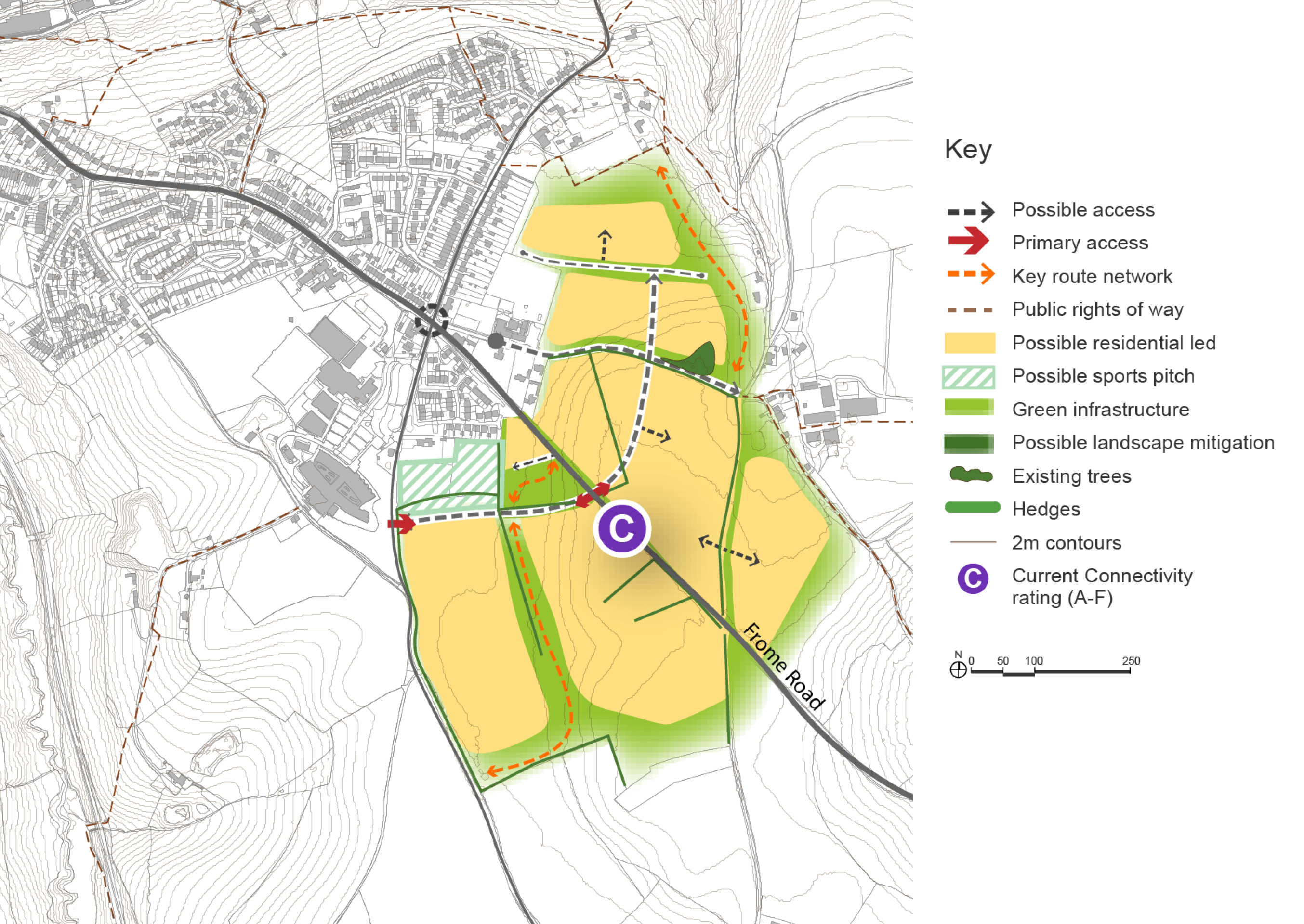
The new development would be located partially on the shallow plateau, with existing hedgerows strengthened and new planting established along key access roads and the new footpath and cycleway network, to help integrate the development into the landscape and in views from the east.
The nearest frequent bus services are located in Radstock town centre, although there may be potential to extend services if critical mass can be achieved. WECA are currently trialling a new 768 service between Writhlington, local villages and Bath.
Vehicle access would be provided from routes which provide connections to the A362. To the north, the A362 connects to Radstock town centre and surrounding residential areas. Access points for active modes can also be provided to both of these routes. Providing a vehicular access onto the A362 offers the potential to reduce the number of traffic movements at the nearby five-ways junction, which could reduce safety and congestion issues.
A larger development might provide the opportunity to deliver better supporting facilities. Providing supporting facilities offers the potential to improve access to amenities for the local population, reducing distances that people need to travel.
If development is extended to the south there could be the option to provide new recreation facilities. There would be a further road connection onto Knobsbury Lane.
Writhlington – Indicative plan
Click to enlarge
Writhlington Site Option – Key information
| Element | Description |
| Development opportunities |
|
| Constraints |
|
| Mitigation |
|
| DfT current connectivity rating |
|
| Further evidence required |
|