Introduction
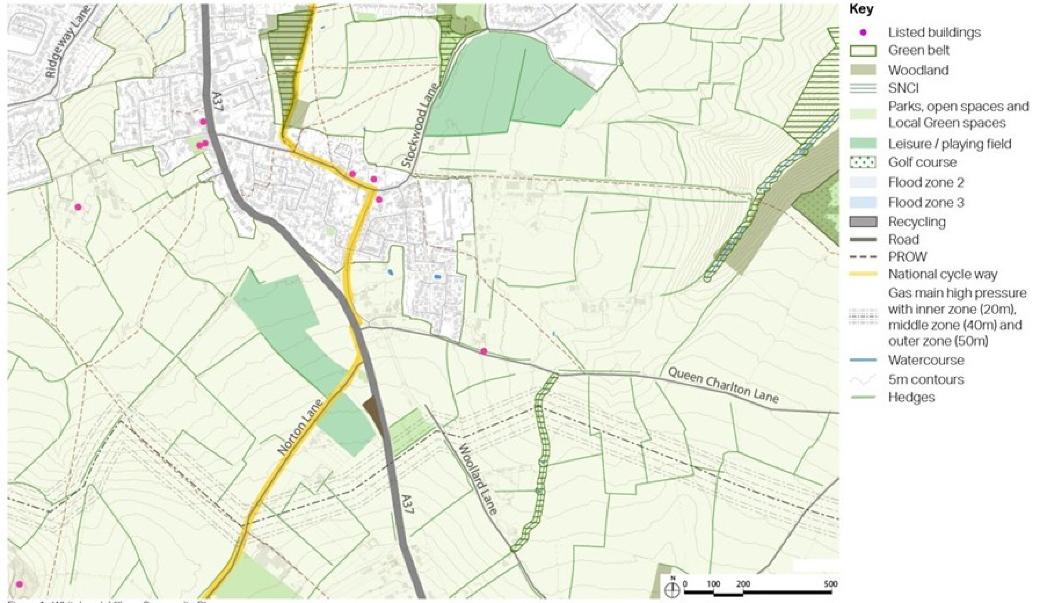
Whitchurch Village is located within the northern part of B&NES, with a population of around 2,000 people. It sits directly south of Stockwood and east of Hartcliffe in Bristol.
The administrative area of Bristol City Council lies immediately to the north and east of the Village. The village of Queen Charlton lies to the east, and the town of Keynsham to the north east. More recent development has increased the number of houses in the village by around 250 homes, but did not bring with it any supporting facilities. The existing village lacks certain amenities such as a village shop, although the existing music shop sells some convenience goods.
Whitchurch Village is surrounded nearly entirely by Green Belt, separating it from Bristol to the north and west, and Keynsham to the east. Any new development adjoining the village would require the removal of land from the Green Belt, and removal would require exceptional circumstances to be fully evidenced and justified within the context of revised national policy, including consideration of whether any land meets the definition of the newly introduced concept of grey belt. This will be informed by Green Belt assessment which is being undertaken to inform the Draft Local Plan.
The local transport network for Whitchurch Village is characterised by the dominance of private car journeys. This contributes to the high traffic volumes on the A37 which bisects the village. The lack of high quality sustainable alternatives, notably a railway station, results in a high proportion of private car journeys, particularly to Bristol. For local journeys, walking, cycling and wheeling are not popular choices because of the lack of safe, attractive and convenient routes. There are a limited range of destinations served by direct bus services, although Whitchurch Village is well-served by frequent bus services to Bristol City Centre.
Sustrans National Cycle Network (NCN) Route 3 links central and south Bristol to the Chew Valley and Wells, passing through Whitchurch Village, along Staunton Lane and Sleep Lane.
The WECA Joint Local Transport Plan 4 (JLTP4) identified the South East Bristol Orbital Low Carbon Corridor project as an opportunity to provide a multimodal orbital corridor close to Whitchurch Village to facilitate north/south connectivity. However, this project is now under review through the preparation of the WECA Joint Local Transport Plan 5 (JLTP5), which is being prepared in the context of the climate emergency declared by each of the local authorities.
Various important heritage assets are located within and surrounding the village. Of particular note is Maes Knoll Scheduled Ancient Monument, which is located around 2km to the south west of Whitchurch Village (see figure 36). Maes Knoll is a substantial, univallate fort enclosing the eastern end and highest point of a plateau of high ground running approximately west to east for around 3km from East Dundry. Maes Knoll is a visually prominent local landmark, with its distinctive flat-topped profile visible across large areas of Bristol and north-east Somerset. In turn, views from the site are very extensive, reaching as far as both Severn crossings and a swathe of historic Somerset. The setting of Maes Knoll is defined by its hilltop location. Its elevated location affords panoramic views of the immediate fields on the hillslopes and the green buffer surrounding suburban Bristol.
Whitchurch Village context plan
Thanks for your patience whilst we create a higher quality image
The local transport network for Whitchurch Village is characterised by the dominance of private car journeys. This contributes to the high traffic volumes on the A37 which bisects the village. The lack of high quality sustainable alternatives, notably a railway station, results in a high proportion of private car journeys, particularly to Bristol. For local journeys, walking, cycling and wheeling are not popular choices because of the lack of safe, attractive and convenient routes. There are a limited range of destinations served by direct bus services, although Whitchurch Village is well-served by frequent bus services to Bristol City Centre.
Sustrans National Cycle Network (NCN) Route 3 links central and south Bristol to the Chew Valley and Wells, passing through Whitchurch Village, along Staunton Lane and Sleep Lane.
The WECA Joint Local Transport Plan 4 (JLTP4) identified the South East Bristol Orbital Low Carbon Corridor project as an opportunity to provide a multimodal orbital corridor close to Whitchurch Village to facilitate north/south connectivity. However, this project is now under review through the preparation of the WECA Joint Local Transport Plan 5 (JLTP5), which is being prepared in the context of the climate emergency declared by each of the local authorities.
Various important heritage assets are located within and surrounding the village. Of particular note is Maes Knoll Scheduled Ancient Monument, which is located around 2km to the south west of Whitchurch Village (see figure 36). Maes Knoll is a substantial, univallate fort enclosing the eastern end and highest point of a plateau of high ground running approximately west to east for around 3km from East Dundry. Maes Knoll is a visually prominent local landmark, with its distinctive flat-topped profile visible across large areas of Bristol and north-east Somerset. In turn, views from the site are very extensive, reaching as far as both Severn crossings and a swathe of historic Somerset. The setting of Maes Knoll is defined by its hilltop location. Its elevated location affords panoramic views of the immediate fields on the hillslopes and the green buffer surrounding suburban Bristol.
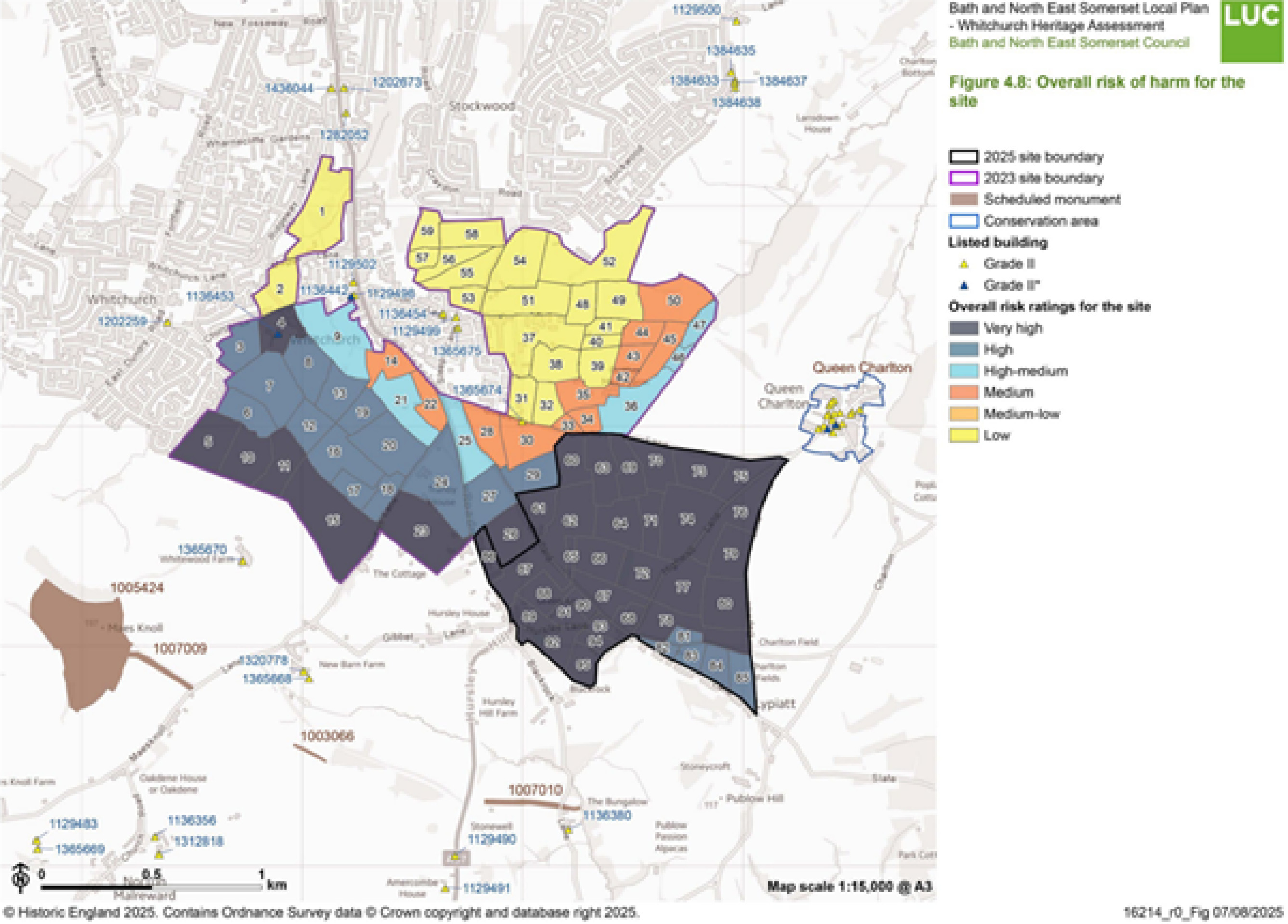
A Statement of Heritage Significance and Appraisal of Risk of Harm for all heritage assets in and around Whitchurch Village, including Maes Knoll Scheduled Ancient Monument, has been carried out to inform the preparation of the options set out in this section . The diagram below provides a summary of this assessment, indicating, using a RAG rating, the parcels of land on which development would likely cause the most harm to the significance of one or more heritage assets.
With the exception of Option 4 which is a larger development of a scale that could potentially deliver significant public benefits as part of a comprehensive and well-planned new development the options shown below for Whitchurch Village have been directed to locations where harm to heritage assets would likely fall within the NPPF definition of ‘less than substantial harm’ or could be reduced by appropriate mitigation such as landscape design solutions. Any future development on land parcels assessed to cause less than substantial harm to a heritage asset will need to weigh this harm against any public benefits that are provided by developing the parcel. Any future development assessed to cause substantial harm should be ‘wholly exceptional’ in line with the NPPF.
The area covered by Option 4 is shown in the Whitchurch Heritage Assessment as being entirely within an area of ‘very high’ risk of harm to the significance of heritage assets. A further area to the south west of Whitchurch Village at Lyon’s Court Farm is also in an area of ‘very high’ or ‘high’ risk, however in contrast to Option 4 it is considered that a smaller residential-only option located south west of Whitchurch Village at Lyon’s Court Farm is unlikely to be able to deliver sufficient public benefits to outweigh the heritage harm. This site has therefore not been proposed as an option in this Local Plan Options Consultation.
The full heritage assessment can be viewed in the supporting evidence base.
LUC Heritage Impact Assessment - Whitchurch overall risk of harm
| Rating | Level of Risk of Harm to Asset |
| Very high | An area of high importance and sensitivity, where development would have the greatest impact. The development of the site is likely to be of such a scale that the significance of the heritage asset would experience significant harm, up to and potentially including ‘substantial harm’ for the purposes of the NPPF, with no potential for meaningful mitigation. |
| High | An area of high importance and sensitivity, where development would have a significant impact. Development of the site is likely to result in a significant harmful impact on the significance of the heritage asset, but this could be reduced (but not removed) via appropriate mitigation. |
| High – medium | Area of medium-high importance and sensitivity where development would have a harmful impact if no mitigation occurred. Development of the site could result in a harmful impact on the significance of the heritage asset but this impact is likely to fall within the definition of ‘less than substantial harm’, and/or could be reduced via appropriate mitigation (such as via landscape design solutions). |
| Medium | Area of medium importance and sensitivity. The development of the site may result in a harmful impact to the significance of a heritage asset but it is likely that these impacts could be avoided via appropriate mitigation (such as via landscape design solutions). |
| Medium - low | Area of medium to low sensitivity. Potential impact will be of such a minimal scale that the significance of the heritage asset will not be harmed. |
| Low | Area of low sensitivity. Development of the site is likely to result in minimal impact on the significance of the asset. It is likely that no mitigation would be required. |
Whitchurch overall risk of harm diagram
Thanks for your patience whilst we create a higher quality image
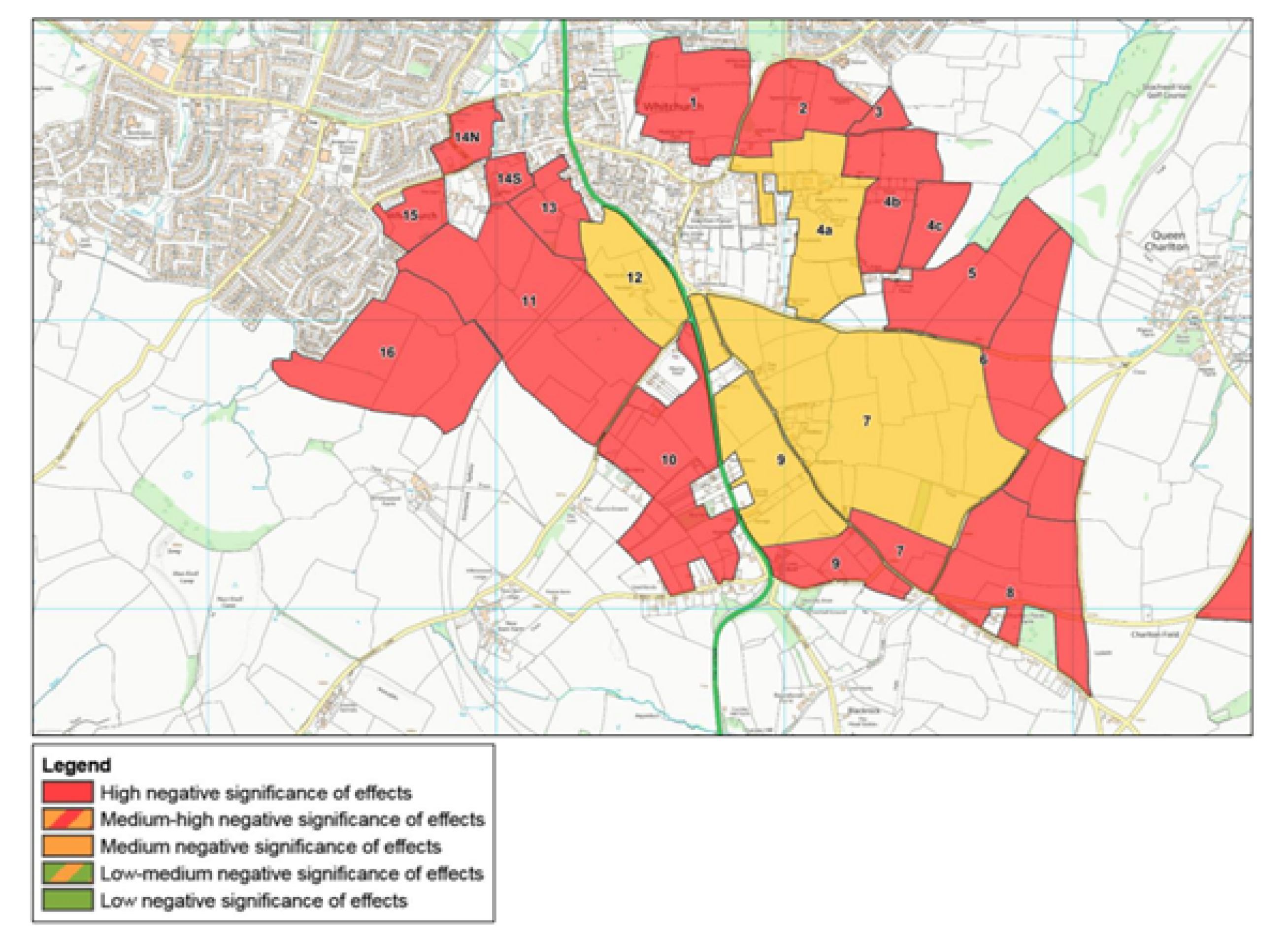
Landscape impact
The area surrounding Whitchurch Village is also highly sensitive in terms of landscape impact. A Landscape and Visual Impact Assessment was carried out in 2017, which assessed the significance of effects of development on landscape and views for land parcels surrounding the village. The summary results of the assessment are shown on the diagram below. All of the site options for Whitchurch Village include development of parcels rated as having a high or medium-high negative significance of effects. These are noted in the constraints for each site, and if any allocations are proposed in Whitchurch Village at Draft Local Plan stage, these will need to be informed by additional landscape sensitivity work, and consideration of potential mitigation.
Thanks for your patience whilst we create a higher quality image
Lack of employment in the local area results in out-commuting, mostly by car.
Whitchurch Village is surrounded nearly entirely by Green Belt, separating it from Bristol to the north and west, and Keynsham to the east.
A number of important heritage assets are located in and around the village, including Maes Knoll and Wansdyke Scheduled Ancient Monuments located to the south west.
Landscape sensitivity assessments carried out in the area surrounding Whitchurch Village indicate that land located to the south of the village, between the village and Maes Knoll, is of particularly high landscape sensitivity, apart from a small parcel of land directly adjoining the A37 to the west, which is assessed to have a medium landscape sensitivity. Parcels of land directly adjoining the village to the east are also assessed as having a medium landscape sensitivity, becoming more highly sensitive moving further east.
There is currently no dedicated shop in the village to buy convenience goods, though the existing music shop sells some convenience items. There are a limited number of commercial units, a pub / restaurant, a primary school and sports facilities. Growth of the village in recent years did not include provision of any supporting facilities.
The existing village primary school could accommodate pupils from around 150 new homes, but any larger scale of development would need to be supported by the provision of a new primary school as there is insufficient space for on-site expansion.
Without the provision of a new secondary school at Whitchurch, secondary age pupils from any new development at Whitchurch Village will need to be transported to school in Keynsham or the Chew Valley, at cost to the council. These pupils will not be able to travel to school sustainably by active modes.
High traffic volumes cause congestion issues along the A37 corridor, particularly at peak times. This can lead to poor air quality.
Footway widths are narrow at points along the A37, and the carriageway width is frequently constrained by on-street parking.
The village play park is well-used, but is located along the A37 at the southern end of the village, accessed via a very narrow footpath along A37. A new signalised crossing to be installed as part of the Whitchurch Liveable Neighbourhood Scheme will improve access to the play park from the east.
The A37 severs the east and west parts of the village, and there are limited pedestrian crossings across the busy road.
There are inadequate walking and cycle facilities on the A37 corridor, owing to the constrained carriageway and footway widths along parts of its length.
There are limited orbital routes available for journeys to the northeast and northwest of the Whitchurch Village for sustainable modes.