Introduction
Saltford is a large village located to the east of Keynsham, with a population of around 4,000 people. Its historic core and conservation area front the River Avon to the north of the village, with numerous heritage assets located within this area.
Over time, the village has grown to the south and west, with development predominantly residential in use, but with a small quantity of retail and commercial businesses located along the A4. Other village facilities such as the village hall and recreation ground are located to the north of the village, and Saltford Primary School is located off Claverton Road towards the south of the village.
Saltford Village occupies a strategic location on the A4 corridor between Bath and Bristol. Sustrans National Cycle Network (NCN) Route 4 links east Bristol with Bath, passing closely to the north and east of Saltford Village. There is a good frequency of bus services operating along the A4 to the centres of Bath and Bristol.
The principal road that serves Saltford Village is the A4. During the traditional weekday highway peak hours, there is congestion typically along the A4.
There is an aspiration amongst the local community and the council to reinstate a railway station at Saltford, and feasibility work is ongoing with WECA, Great Western Railway (GWR) and the Department for Transport (DfT) investigating location options for the station, costing and deliverability. At this stage two broad areas are being considered along the railway alignment, to the south east (near where the previous Saltford station was located before it closed in 1970), and to the north west of the village.
Saltford Village is surrounded by the Bristol and Bath Green Belt. The Cotswold National Landscape is located directly to the east of Saltford, with impressive sweeping views across the two settlements visible from across the designated area.
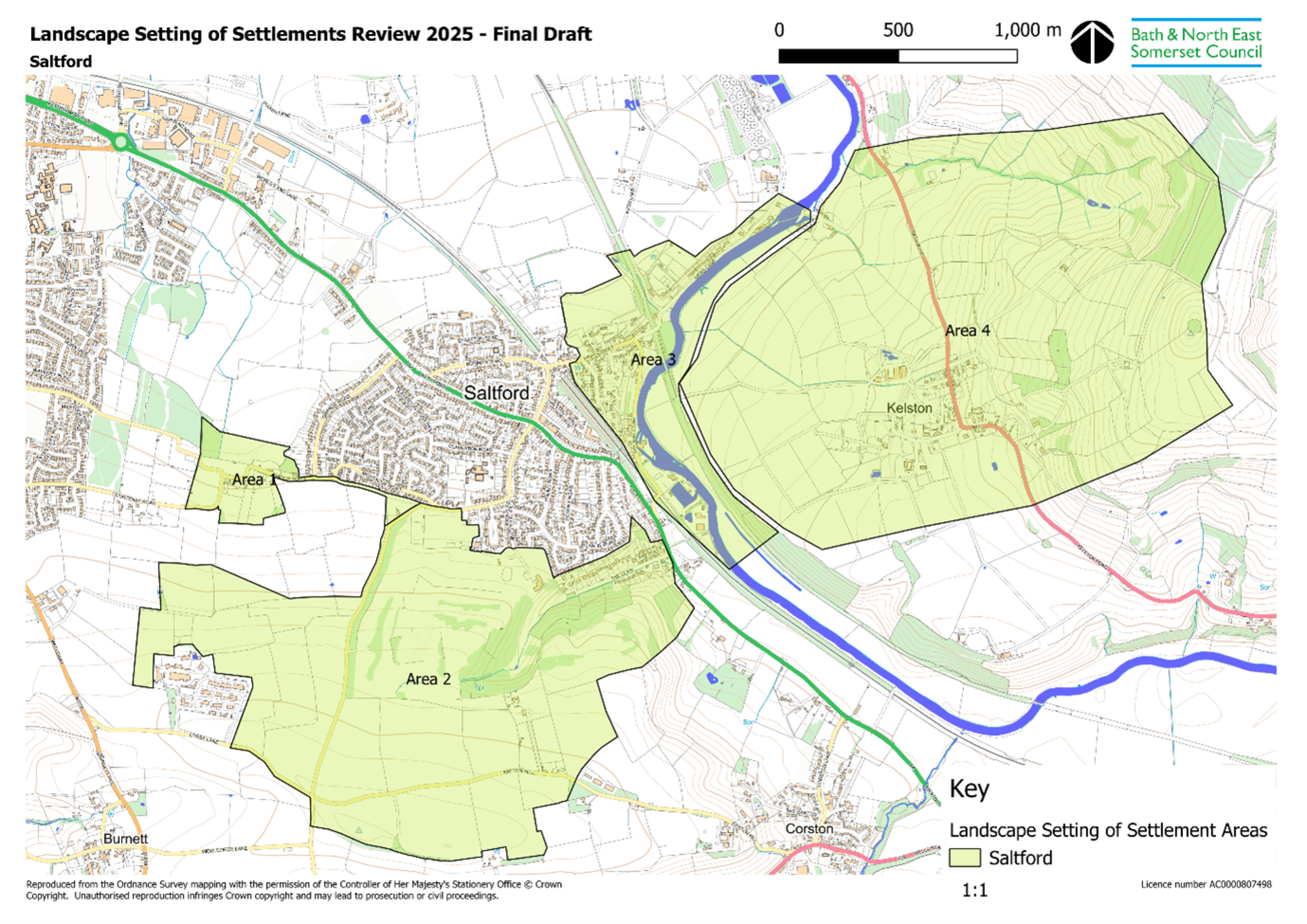
A local designation in the adopted Local Plan relating to the Landscape Setting of Settlements wraps around much of Keynsham and to the north, east, and south of Saltford Village. The designation as shown on the Policies Map and associated policy requires that development should only take place if it conserves and enhances this landscape setting. In the 2024 Options consultation the council sought comments on the extent of the existing designation and whether the boundaries of any existing landscape settings of settlements identified on the Policies Map should be amended. Since the 2024 Options consultation the council has committed to undertaking a review of the landscape setting of towns and villages across the district where Policy NE2A applies (see the Development Management Policy Options section for further discussion).
Settlements often have landscape settings which not only contribute to their distinctive character and quality, but are also highly valued reflecting their significance as places where people live and work. There is on-going need for further development; in particular for housing, which is primarily focused on the larger settlements, but also in the more sustainable villages throughout B&NES. The purpose of Policy NE2A and the Landscape Setting Areas is to ensure the protection of key landscapes and landforms; landmarks; and views / viewpoints which particularly contribute positively to the form of the settlement; to its distinctive character and identity; and which are considered to influence the creation of a strong sense of place.
The policy and its associated methodology was first adopted in 2015 as part of the Place Making Plan. The council has progressed a review of the policy and its associated methodology to inform the new Local Plan (2025-43) in preparation. The review was triggered by a request from Saltford Parish Council for the surroundings of Saltford Village to be designated as an Area of Great Landscape Value (AGLV) and also responds to background evidence carried out by an independent expert consultant in December 2024.
The review includes the addition of a landscape setting for six new settlements (see the Development Management Policy Options section for further discussion). In addition, it includes a review of the Saltford Landscape Setting Area, which was previously assessed in 2015 (see map below indicating the proposed reviewed and revised setting). The supporting evidence which has informed this review can be found on the council’s website.
In the proposed options, the council presents options to retain or strengthen Policy NE2A and to include the Landscape Setting Area amendments reflecting the Saltford Village review (image below) and defined setting for the six new settlements added.
At the time of this Options Reset consultation the landscape setting review remains in progress and will be progressed further in preparation for the Draft Plan consultation in 2026. Therefore, it is anticipated that more landscape settings of existing settlements will be reviewed in line with the revised methodology in preparation for the Draft Plan consultation.
Landscape Setting of Settlements Review 2025 - Final Draft
Click to enlarge
Keynsham and Saltford Village Area
Given the strong physical and functional relationship between Keynsham and Saltford Village, the following section ‘Key Issues and Opportunities’ has been prepared for Keynsham and Saltford Village together as a whole; with specific references to matters that are of relevance to Keynsham or Saltford Village made where necessary.
The Bristol and Bath Growth Zone is a key element of the WECA Local Growth Strategy. The zone will recognise the planned infrastructure improvements and housing developments along the Bristol to Bath Corridor, exploring the potential to partner with WECA to deliver key employment and housing sites as well as transport projects, especially mass transit and Saltford rail station.
Whilst Bath and Bristol centres are readily accessible by public transport, the new communities created in the locality are likely to look towards Keynsham Town Centre meeting their day-to-day needs, and for a certain scale of leisure and cultural activities. There are likely to be significant opportunities for Keynsham Town Centre to enhance its current role and to increase its offer. The Local Plan will provide a proactive policy framework to enable this to happen and to ensure that town centre sites are developed in a way that supports increased demands.
Evidence from the Future Economic Needs Assessment Update (May 2025) suggests net employment land requirements over the Plan period in the Keynsham area comprise around:
- 12,000 – 13,000 sqm office space (2 ha land requirement)
- 8,000 sqm industrial floorspace (2 ha land requirement)
- 16,000 – 17,000 sqm warehousing / logistics floorspace (3 ha land requirement)
Some of this employment land requirement can be provided through existing commitments i.e. sites with planning permission or allocated in the adopted Local Plan for employment development. These existing commitments will need to be reviewed in preparing the Draft Local Plan.
The need to protect existing and provide new employment space within Bath is significant and land availability is limited. The strategy and priority is to meet Bath’s full need for employment premises within and potentially on the edge of the city. However, if this is not possible the Bristol to Bath Corridor area, and specifically locations along the A4 at Keynsham, Saltford Village and Hicks Gate, could play a more strategic role in contributing to meeting Bath’s needs. This will need to be explored in working towards the Draft Local Plan and may require a change in residential capacity at the site options to accommodate additional employment land.
Land surrounding Keynsham and Saltford Village is designated as Green Belt. Any new allocations adjoining the settlements would require the removal of land from the Green Belt, and removal would require exceptional circumstances to be fully evidenced and justified. Measures to improve the quality of the remaining Green Belt should be explored, including accessible green spaces and nature recovery, with funding to deliver such improvements identified. Exploring opportunities for nature recovery will be informed by the West of England Local Nature Recovery Strategy.
Flood risk from the River Avon to the north of Keynsham and the east of Saltford Village restricts potential development in these areas.
The Bath to Bristol Strategic A4 Corridor experiences significant congestion in both directions during peak times, including through the centre of Saltford Village. Congestion on the A4 also causes delays in Keynsham town centre and worsens air quality.
Whilst Keynsham and Saltford Village have had their designated Air Quality Management Areas revoked in recent years as a result of improvements to air quality, there is the potential for additional development and transport in the Bristol to Bath Corridor to cumulatively worsen air quality in the area. Developments could affect air quality in both B&NES and Bristol and an air quality assessment that considers the cross boundary and cumulative impact effects will be required.
Keynsham’s car parks are reasonably well utilised with a peak occupancy of 75%. However, this is over a relatively short time period with a 7-day mean occupancy of 55%, indicating a surplus of car parking in the town.
Public space is more balanced towards vehicles over people, causing issues with congestion and severance.
Many areas along the corridor lack effective walking and cycling connections to the wider network, with routes often fragmented and poorly integrated with strategic corridors. There is currently no direct, continuous walking or cycling route into Bristol, which significantly restricts accessibility and limits active travel options for residents. There is poor access to Keynsham Railway Station on foot, bicycle, and bus, particularly from the A4 corridor.
Keynsham and Saltford Village are located in an area of landscape sensitivity. The Cotswolds National Landscape is located to the east with views across, and a local designation relating to the Landscape Setting of Settlements is to the north, east and south of Saltford Village, and wraps around much of Keynsham.
Keynsham is bisected by the River Chew, which provides an important landscape, wildlife and recreational corridor through the town, but also creates movement severance for people due to limited crossings over the river. Weirs along the river currently provide barriers to fish passage for migratory fish.
Keynsham and Saltford Village contain numerous important heritage assets which require protection.
Keynsham lacks a cultural space/venue such as a hall with theatre for use by community.
Keynsham and Saltford Village have health and wellbeing needs that the built and natural environment can play a role in addressing, including food insecurity, cardiovascular, respiratory and healthy weight needs.