Click here to view the draft character appraisal and management proposals, or find out more via the tabs below.
What is a conservation area?
A conservation area is defined as an “area of special architectural or historic interest, the character and appearance of which it is desirable to preserve and enhance.” The historic core of Radstock was designated as a conservation area in 1999.
What is the purpose of a character appraisal?
The Council has a duty to preserve and enhance the character and appearance of conservation areas in exercising its planning powers. The council’s planning policies require a higher degree of design management in conservation areas.
An appraisal reviews boundaries and identifies features which contribute toward the special interest and character of the area, and those that detract from it. This provides a base for developing management proposals for preservation and enhancement.
What happens next?
Following this consultation all comments received will be reviewed and the documents will be amended. The final character appraisal, conservation area boundary changes and management proposals will be used by the council to assist the development of the area and its setting.
- Mining legacy: Radstock stands as a rare example of an early industrial landscape where small-scale mining coexisted within a rural community. Radstock retains many important colliery features.
- Relationship to rural setting: Attractive rural setting, long vistas into and across valleys, well-preserved relationships between the town and surrounding landscape.
- Historic communication routes: Evidence of various historic communication routes, including canals, railways, and colliers’ paths has survived
- Architectural cohesion and use of local materials: The consistent use of local building materials (primarily lias stone and slate roofs) and proliferation of standard building types (such as miner’s terraces)
- Surviving cooperative and institutional buildings: 19th century cooperative and institutional buildings and non-conformist chapels showcase the social and economic influence of these movements on Radstock
- Surviving pre-industrial historic core: The area surrounding St Nicholas’ Church still holds some characteristics of the medieval town, demonstrating the close relationship between agriculture and village life.
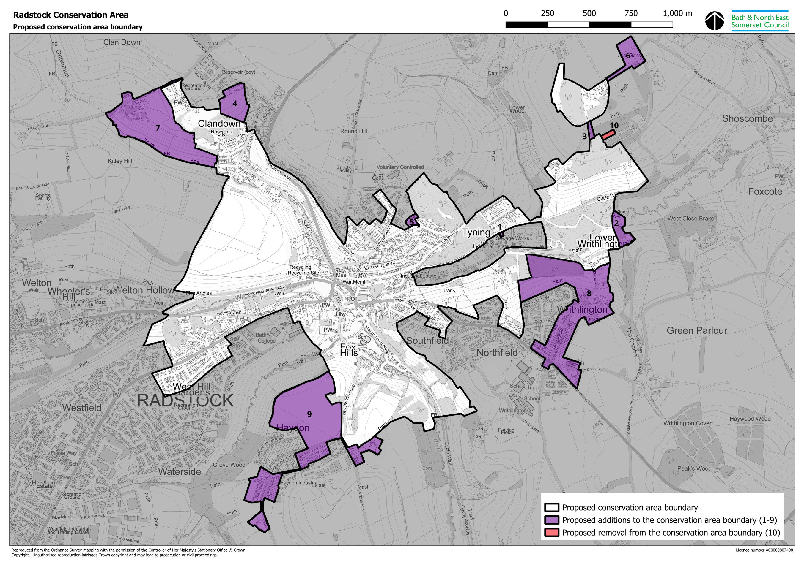
Proposed additions
- Clandown: Clandown Farm and Pow’s terrace, along with surrounding land which forms its agricultural setting.
- Tyning: The 19th century Tyning Inn and a short terrace, formerly known as Lower Butter Buildings. Also, a single-storey century stone building within the compound of the sewage treatment facility, thought to be an early 20th century pump house.
- Upper Braysdown: The old colliery trackway south of Braysdown Colliery, and the c.1900 Peasedown Allotments and a pair of miners’ cottages to the north-east of the colliery.
- Writhlington: The historic core of Writhlington, continuing south down Manor Road and to parts of Frome Road, including Hylton Row, the early 19th century listed Fir Tree Inn, and St Mary’s Primary School.
- Haydon: The miners’ terraces which grew up around Kilmersdon Colliery (now demolished, excluded from the boundary), and the line of the former tramway. Also, two Grade II Listed farms which pre-date the colliery.
Proposed removal
- Braysdown Shed: The shed was constructed in the 1990s and does not contribute to the character of the conservation area. It is therefore proposed to exclude this from the boundary.
A detailed description of the proposals is included within the appraisal document, which can be viewed here. Topics cover:
- Protecting the conservation area landscape setting
- Managing new development
- Managing changes to existing buildings
Possible Enhancements:
- Improve community space within the town centre
- Improve pedestrian and cycle movement around the centre
- Streetscape improvements, including planting, surfacing and signage
- Enhance the visual amenity and habitat of Wellow Brook
- Maintain signposting relating to walking and cycling trails, and heritage information boards
- Promote high quality shopfront design and signage
In a conservation area, development proposals should:
- Preserve or enhance the character or appearance of the area
- Reflect local built character through use of traditional materials, architectural detailing, scale, height and form
- Respect historic and established street layouts, plot boundaries and urban grain
- Consider the impact upon the setting of the conservation area, and upon important views within, from and into the area.
- Seek to ensure non-designated heritage assets are conserved, having regard to their significance.
In a conservation area, planning permission is needed to:
- Clad any part of the exterior of a building
- Add to or alter the shape of a roof
- Construct a two storey rear extension or an extension or outbuilding at the side(s) of the property
- Demolish a building with a volume of more than 115 cubic metres
- Demolish a gate, fence, wall or railing over 1 metre high next to a road, footpath or public open space
- Demolish any gate, fence, wall or railing over 2 metres high
- To confirm whether permission is required before undertaking any works, please contact us.
Works to trees in a conservation area:
- You must give the Council 6 weeks notice for the pruning or felling of trees which are over 75mm in diameter when measured at 1.5m above ground level, unless an exemption applies.
- Exemptions include the felling of a dead or dangerous tree, for which you should give 5 working days notice.
- To confirm whether you are required to give notice for proposed tree works, please contact us for clarity.