West Whitchurch Site Option
The West Whitchurch site is located to the west of the A37, between Norton Lane to the south, and Blackacre to the north.
The land is primarily used as arable fields. However, the Bristol Barbarians RFC club is located in the southeastern part of the area, which would need to be relocated to the south if this option was to be taken forward.
The site is located in the Green Belt. Any release from the Green Belt and subsequent allocation for development will need to demonstrate exceptional circumstances. To understand and consider the impact of potential development on the Green Belt an assessment of the extent to which different parcels of land serve the five purposes set out in national policy is being undertaken. The emerging Stage 1 Strategic Green Belt Assessment being carried out by WECA will assess the site for its contribution towards meeting the five Green Belt purposes and also whether it meets the definition of grey belt set out in the NPPF and updated Planning Practice Guidance, which is now sequentially preferable to greenfield Green Belt in national policy. The assessment work is ongoing and will inform the Draft Local Plan. It is likely that following the Stage 1 Strategic Green Belt Assessment a more detailed (stage 2) assessment of the impact of development on more specific areas of the Green Belt will also be required.
West Whitchurch Site Option – Indicative plan
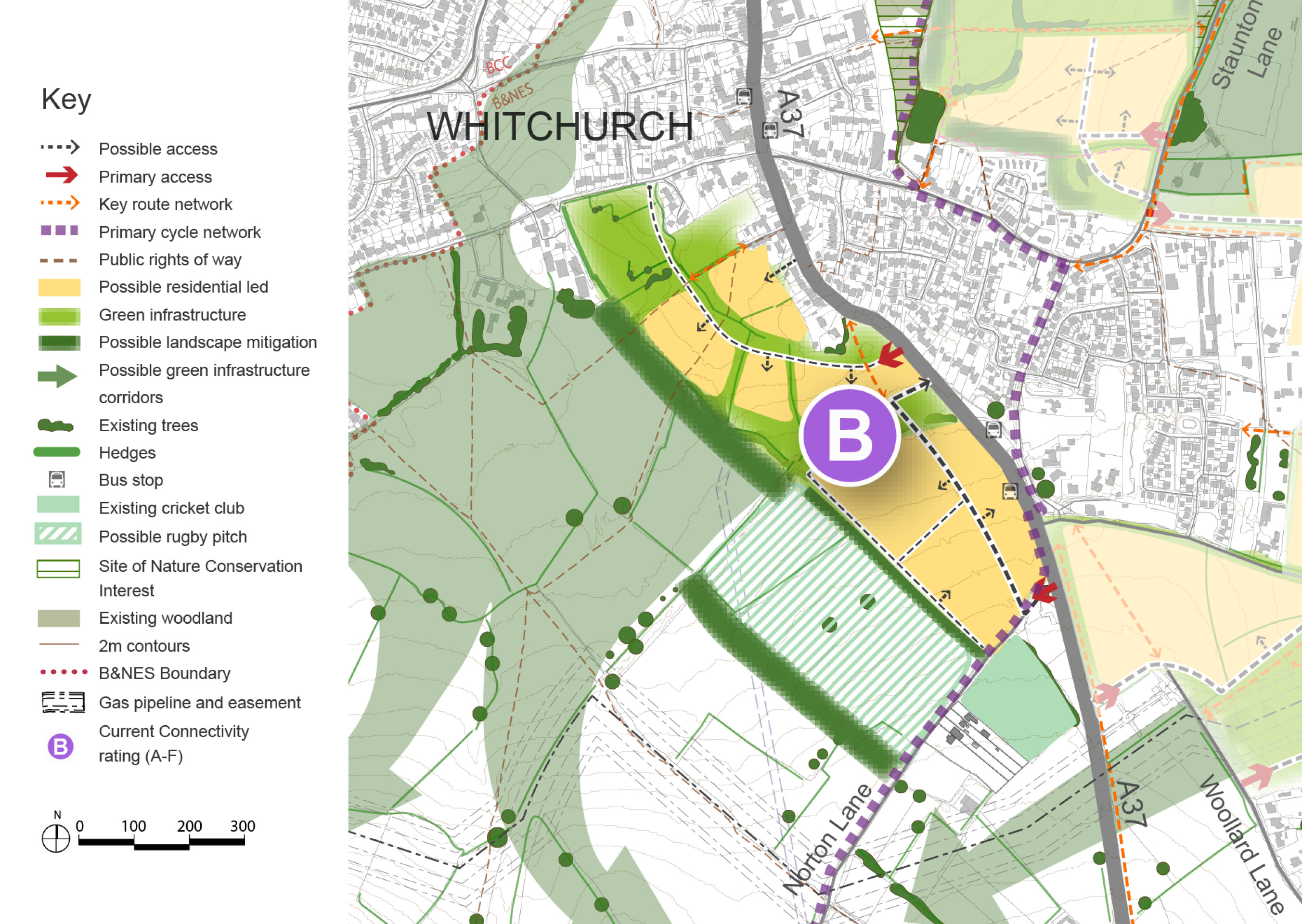
Click to enlarge
West Whitchurch Site Option – Key information
| Element |
Description |
| Development opportunities |
- Provision of around 350-450 homes, plus extension of existing village centre along A37, with provision of a primary school (if brought forward in combination with other options), village green, village shop, and other community facilities. Development of this site in isolation would not require the delivery of additional primary school places in the Whitchurch area.
- Located close to the existing village centre, and with good access by active travel modes to facilities located in Whitchurch Bristol.
- Safe and attractive walking route from north west end of village to existing village playground.
- Public realm improvements along the A37 to improve pedestrian and cycle connectivity, with local mobility hub connecting to national cycle route
|
| Constraints |
- Located in the Green Belt.
- Requires relocation of rugby club further south.
- Further exploration required relating to whether relocated rugby club could be adequately accommodated within the existing hedgerow network, with buffers.
- The majority of this option is located within areas assessed to have either a high-medium, or medium risk of harm to heritage assets in the area. In these areas it is considered that development could result in a harmful impact on the significance of heritage assets but this impact is likely to fall within the definition of ‘less than substantial harm’, and/or could be reduced via appropriate mitigation (such as via landscape design solutions). Some of the land parcels located to the south west of the option are located in areas assessed to have a high risk of harm to heritage assets, where it is considered that development would likely result in a significant harmful impact on the significance of heritage assets, but that this could be reduced (but not removed) via appropriate mitigation. Any harm will need to be weighed against public benefits that are provided by developing the parcel.
- Development would impact historic field pattern to the west of A37.
- Located in area of high landscape sensitivity – further assessment and consideration of appropriate mitigation required.
- Secondary school pupils would need to be transported to school at cost to the council, and would not be able to reach school using active travel modes.
- Although located close to the existing village centre and facilities within Whitchurch Bristol, without improved public realm and crossings along A37, severance with the existing village could occur.
- The availability and frequency of public transport services, particularly bus services, is currently dependent on external funding, which is subject to ongoing review and cannot be guaranteed over the plan period. This uncertainty should be taken into account when considering the sustainability and deliverability of this option.
|
| Mitigation |
- Careful consideration of pedestrian and cycle crossings required within public realm improvements to alleviate severance issues.
- Significant green infrastructure and planting required throughout and along the edge of the development parcels, to provide softening to edges of development, and mitigate impact on landscape and heritage assets located to the south
|
| DfT current connectivity rating |
|
| Further evidence required |
- Landscape sensitivity assessment and mitigation.
- Green Belt assessment required to assess impact of removing land from Green Belt, including cumulative impact when considering strategic removal across the district.
- Further heritage assessment required relating to levels of harm to heritage assets, and consideration of weight of harm against public benefit.
- Impact of development on historic field patterns to be considered.
- Evidence to consider secondary school place planning in the Wellsway and Broadlands catchment areas, in combination with other proposed allocations in the area.
- Evidence to support requirements for strategic green infrastructure and nature recovery
- Air quality assessment
|
Return to the interactive map
Return to the site options page