Strategy Overview and Key Issues
Home to over 37,000 residents, rural B&NES is a diverse group of towns, villages, and hamlets with distinct characteristics and landscapes which accounts for over 90% of the district’s land area. Each settlement has their own strengths and challenges. Traditionally the rural economy has been based on farming, self-employment and small businesses, which without the right support limits growth potential. Poor public transport and digital connectivity also act as barriers to business and home working, contributing to social isolation and unequal access to essential goods and services. 78% of rural residents commute to work by car, and alongside high transport related emissions, highlights the need for more local employment and sustainable travel options for our rural communities.
In 2022, house prices in B&NES were more than 10 times annual median average earnings, creating challenges across the district. The lack of affordable housing in our rural communities threatens the vitality of local businesses and the social sustainability of our towns and villages
Set amongst high quality natural environments, the villages and hamlets of the rural areas of the district provide an attractive and often peaceful environment in which to live and work. The economy of the rural areas is grounded in agriculture, which now works alongside other small rural businesses. The high-quality landscape, of varying characters, contributes to the quality of life of the district’s residents, as well as attracting visitors and as a place for leisure and relaxation.
Large parts of the rural areas are designated as Green Belt, and much are within the Cotswolds or Mendip Hills National Landscapes. The rural areas complement the more urban parts of the district, and many rural residents look to these urban areas for a wider range of facilities and employment.
The current approach to rural development, as delineated in the Placemaking Plan and Core Strategy, categorises our villages as follows:
- RA1 Villages: Non-Green Belt villages boasting primary schools and, crucially, at least two of the following essential amenities within the village - a post office, community meeting space, and convenience store. Furthermore, they benefit from at least a daily Monday-Saturday public transport service to major centres. Policy RA1 required allocation of sites to deliver around 50 dwellings in each village.
- RA2 Villages: Non-Green Belt villages that fall outside the RA1 scope, characterised by site allocations to deliver around 10-15 dwellings in each village.
- GB2 Villages: Villages washed over by the Green Belt, where development is restricted to infill only.
It is becoming increasingly evident that the current strategy is leading to the relative dispersal of development across a wide range of settlements. This is an unintended consequence of the approach outlined above and has led to a number of issues this Local Plan needs to address.
Many of these issues have been picked up from feedback received to the both the 2024 Options and Launch Consultation as well as Workshops with parish councils and other community representatives. These key issues can be summarised as:
- Lack of affordable housing to meet local needs that may impact on the social sustainability of the rural areas and exacerbate difficulties for an ageing population.
- For much of the rural area poor access to public transport affects the functionality of the rural economy and leads to isolation for those without access to private transport.
- Access to cultural infrastructure, including community and social facilities, services and shops.
- Importance of maintaining and enhancing the character and local identity of our rural areas and communities.
- Reliance of the rural economy on farming, the self-employed and small businesses that require support to flourish.
- Potential opportunities to diversify the rural economy e.g. centred around local food production, sustainable rural and eco-tourism, renewable energy, or the natural resources sector.
- Poor digital connectivity continues to be a barrier to business growth, home working, and access to services, and must be addressed to support economic and social inclusion.
- The ageing population in rural areas presents specific challenges for housing, healthcare, and service provision, requiring more adaptable and accessible infrastructure.
- Climate change resilience and adaptation must be embedded in rural planning, including flood risk management, sustainable land use, and energy efficiency. Protection and restoration of natural capital and ecosystem services is essential to support biodiversity, climate goals, and the long-term sustainability of rural communities.
- Rural areas are not a single place – they encompass varied geographies and identities, and strategies must be flexible and locally responsive
The following list sets out the key priorities for the Rural Area. Many of the priorities can be addressed through development, either Local Plan-led or by communities through Neighbourhood Plans. However, there are some issues that won’t be addressed through new development but will be addressed through other policies in the Local Plan, or by strategies or initiatives undertaken by the council or by other stakeholders.
- Create vibrant, inclusive rural communities where people of all ages can live, work, and thrive, supported by affordable homes, accessible services, and strong social infrastructure.
- Champion a green rural economy that supports local enterprise, sustainable tourism, and innovation in food, energy, and land-based industries.
- Transform rural connectivity by delivering a network of safe, accessible walking, cycling, and wheeling routes, and by improving public transport and digital infrastructure.
- Empower communities to shape their future, supporting locally-led development through Neighbourhood Plans, community land trusts, and rural exception sites.
- Plan for climate resilience and environmental recovery, embedding nature-based solutions, low-carbon design, and flood adaptation into all aspects of rural growth.
- Unlock the potential of strategic rural development, where appropriate, to deliver wider benefits such as employment land, new services, and infrastructure that sustain long-term community wellbeing.
- Celebrate and protect the unique character of rural places, ensuring that growth enhances rather than erodes the landscapes, heritage, and identities that define them.
- Respond to national challenges with local solutions, using the Local Plan as a springboard for bold, place-based planning that meets housing need while respecting local distinctiveness.
The Government’s Unleashing Rural Opportunity report sets out a framework to support rural communities across the UK. Since its publication, progress has been made in areas such as digital connectivity, transport, and rural economic diversification. However, access to funding for rural areas remains limited and uneven. In B&NES, the UK Shared Prosperity Fund (UKSPF), administered through the West of England Mayoral Combined Authority (WECA), has provided support to rural communities. Five rural parishes have successfully delivered energy efficiency and biodiversity projects, demonstrating the effectiveness of a decentralised delivery model. These include:
- Farmborough Village Sport & Social – installation of an air-to-air source heat pump and hot water system in a refurbished building to reduce energy consumption.
- East Harptree and Bishop Sutton – installation of solar panels on community buildings.
- Compton Martin – insulation added to the vaulted roof of the village hall.
- Chelwood Parish Council – roof repairs and insulation of the village hall.
- Chew Magna Old Schoolroom Charity – retrofitting a room to improve resilience to flooding events.
These projects highlight the potential for community-led, place-based investment in rural areas. However, the scale of funding available remains limited, and further support is needed to ensure that rural communities across B&NES can fully participate in the transition to a greener, more resilient economy. The council’s Economic Strategy is also seeking to support the diversification of the rural economy and realising opportunities to facilitate moves towards a greener economy, including growth in environmental services and natural resources sectors, as well as sustainable rural and eco-tourism. Improvements in digital infrastructure and changing work practices also creates opportunities to diversify and enhance the rural economy. A stronger rural economy, providing opportunities for local residents to access good jobs, is a vital component of more sustainable rural communities, alongside efforts to retain and improve local services and facilities.
Improving connectivity is also a key priority for rural communities. The Active Travel Masterplan sets out a 20-year vision to make walking, wheeling, and cycling the natural choice for more journeys across the district. It proposes a holistic network of safe, accessible, and interconnected routes that link rural settlements to key services, employment, and public transport hubs. By reducing reliance on private vehicles, the Masterplan supports climate goals, improves air quality, and enhances health and wellbeing. For rural areas, it offers the opportunity to address isolation, improve access to services, and strengthen local economies through better physical connectivity.
Enhancing public transport is also a key priority for rural communities in B&NES. The council’s approach focuses on a simple, dependable and integrated rural bus network that links villages to key services, employment and town centres via well located mobility hubs, supported by bus priority on strategic corridors such as the A37, A367 and A362. WECA’s forthcoming work on bus ownership options will help to inform how rural services are specified and delivered. Some key rural public transport services, particularly buses, are currently WECA grant funded and it is vital that this funding remains in place in order to support existing rural communities, as well as potential additional development. However, the future of this funding is uncertain and subject to periodic review, which should be taken into account when considering options for allocation in the Draft Local Plan.
Green infrastructure is a network of multi-functional green and blue spaces and other natural features, urban and rural, which is capable of delivering a wide range of environmental, economic, health and wellbeing benefits for nature, climate, and communities. Opportunities to enhance and extend the Green Infrastructure network should be central to the design of new developments, and development proposals should demonstrate strong links to the wider green infrastructure network.
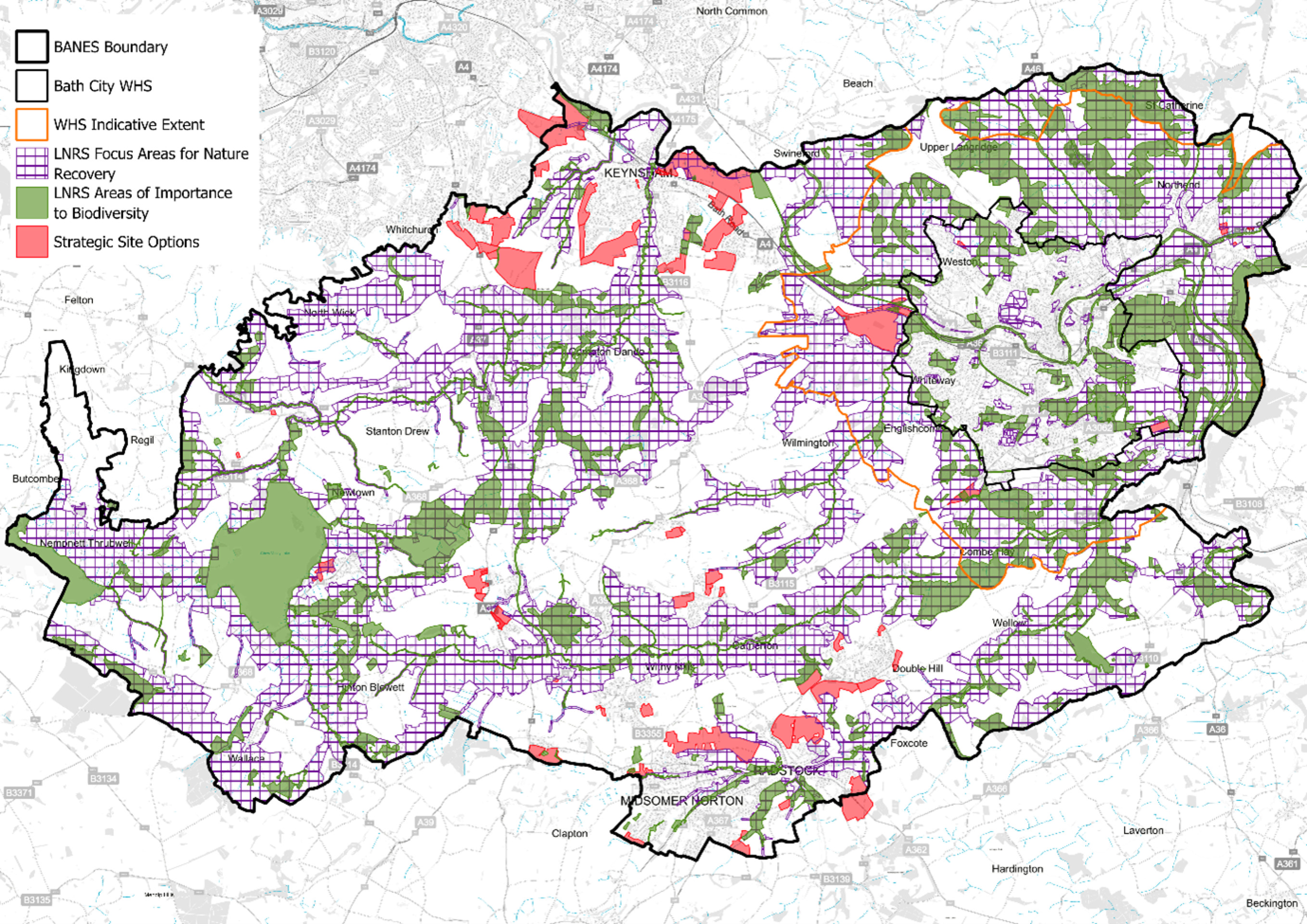
The WECA Local Nature Recovery Strategy and Toolkit (LNRS) was published in November 2024. The LNRS identifies the following areas:
- Areas that are already of importance to biodiversity. These are sites that are nationally are designated for their value to nature, such as Sites of Special Scientific Interest (SSSIs), Special Areas of Conservation (SACs) and Special Protection Areas (SPAs),.It also includes sites that are designated as Local Nature Reserves; ,sites that are locally designated as ‘Sites of Nature Conservation Interest’ (SNCIs), and/or are irreplaceable habitat, including ancient woodland.
- Focus Areas for Nature Recovery. This is where action to recover nature will have the biggest impact and is most feasible. These have been mapped to reflect the priorities for nature recovery, and include all of the mapped measures for nature recovery. The focus areas for nature recovery are referred to as ‘areas that could become of particular importance’ in regulation.
The plan below shows where these areas are located in the Rural Area, and the relationship between these areas and the Site Options under consideration in this Options consultation. Constraints and opportunities are referenced for each Site Option where appropriate.
WECA LNRS areas and district wide strategic site options
Central to the vision and priorities for the rural areas is the need for proportionality to growth, ensuring that development aligns with the unique characteristics and needs of individual communities. Without a deliberate focus on proportionality, development can risk overburdening smaller villages or inadequately serving larger ones. However, as a result of changes to national policy and the Government’s proposed revised housing figure, aimed at tackling the country’s acute housing crisis and stimulating economic growth, the council reset the Local Plan in February 2025. This reset discussed the increased housing pressures across the district, including in rural areas. While proportionality remains a guiding principle, there is now a need to consider whether some comparatively sustainable rural locations may be suitable for larger-scale development.
Pathway 1: Community-Led Growth
Under this pathway, local communities take the lead in shaping and advancing their growth initiatives. Emphasising community involvement, this approach offers a flexible framework, enabling residents to propose growth projects that align with their local aspirations. Using a range of tools, including rural exception schemes, community land trusts, and Neighbourhood Planning, empowering communities to initiate growth projects.
Pathway 2: Local Plan-Led Growth
Including rural exception schemes, community land trusts, and Neighbourhood Planning, empowering communities to initiate growth projects.
Pathway 2: Local Plan-Led Growth
As communities contemplate the pursuit of their growth proposals, it is essential to maintain efforts in preparing the new Local Plan to ensure the certainty of delivering new developments, especially housing and employment opportunities.
Taking these steps is vital to:
- Positively plan and reduce the possibility of speculative developments.
- Facilitate the development of new affordable, market, and specialised housing to meet the needs of rural communities.
- Support existing services and facilities.
- Enable investment in new infrastructure, including employment space, schools, and transport improvements, where larger-scale development is appropriate
In opting for a Local Plan-led/site allocation approach to rural growth and development, there are several inherent benefits that prioritise the holistic well-being of our villages. Unlike speculative large site development, which can introduce unforeseen challenges for essential functions like schools, transport, and community facilities, a Local Plan provides a structured and comprehensive framework.
Pathway 2 focuses on a Local Plan-led approach that provides a clear direction for growth and change, adhering to the NPPF's principles of sustainable development. This approach is essential in helping to meet our overall housing, job, and infrastructure requirements and provides certainty for both communities and developers. The principle of "proportionality" is central to this approach, ensuring that growth aligns with the unique needs and character of each community. However, proportionality must now be considered in the context of increased housing requirements and the need to deliver development that brings meaningful benefits to rural communities.
Pathway 2 focuses on guiding new development in rural areas by identifying relatively sustainable villages. Instead of adhering to the rigid distinctions of RA1 and RA2 villages, a more flexible and proportionate approach will be taken.
As part of the Local Plan process, we are also separately consulting on amended Housing Development Boundaries (HDBs) for rural settlements. This includes an option for a revised methodology for defining HDBs, primarily to ensure they reflect changes on the ground and address known inconsistencies. While the main purpose is to provide clarity and alignment with current circumstances, the amended boundaries may also enable a limited amount of small scale ‘windfall’ growth in appropriate locations. This consultation runs alongside the site options process and complements the identification of relatively sustainable villages, helping to ensure that all forms of rural growth, whether plan-led or windfall, are managed in a coordinated and locally responsive way.
The strategy for rural growth is based on an assessment of a village's sustainability, considering factors such as connectivity through sustainable modes of transportation (public transport, walking, cycling and wheeling) and the availability of essential services and facilities.
In conjunction with this approach, place profiles have been prepared for our villages and parishes. These profiles incorporate an analysis of past growth since the start of the Core Strategy plan period, demographics, connectivity, facilities audit, and other key issues. The outputs of this work are outlined in a Topic Paper (published alongside the Options document) and the associated identification of relatively sustainable villages for consideration are set out in the following pages.
The villages identified as relatively sustainable compared to others are proposed to become the focus of attention for some Local Plan led rural growth. Our commitment is to engage with the community and parish council in these villages to explore the potential for growth, its location and the associated benefits that such development could bring e.g. meeting local housing needs or providing employment opportunities, helping to keep villages viable and sustainable. We have met with parishes that have engaged with us, and as a result, we have identified site options within these areas to set out our thinking on the most appropriate locations and scales of potential growth. If taken forward this development would be on large sites that would then be allocated for development in the Draft Local Plan and would be additional to any small windfall sites (often sites for one or two dwellings) that might come forward within the Housing Development Boundary for each village during the plan period. In preparing the draft Local Plan we will also need to consider whether there are opportunities to phase development in the villages in the context of the need to maintain a five-year housing land supply across B&NES. Opportunities outlined in the Housing and Economic Land Availability Assessment (HELAA) were considered as a starting point for potential locations. In addition, the February 2025 Call for Sites has provided further opportunities to assess land availability and suitability across the district.
As part of this process, parish councils were offered training on site assessment, and many have reviewed HELAA opportunities within their areas. Through this collaborative approach, at some villages previously identified for proportionate growth no site options are identified at this time due to either a lack of development opportunities or the high levels of harm that could result from Local Plan scale growth. We continue to work with these parishes and encourage them to pursue Pathway 1 (Community-Led Growth) as an alternative route to meet local needs. We will continue to work closely with community representatives as the plan progresses to ensure that any development aligns with their aspirations while preserving the distinct character and vitality of each rural area.
Should other villages wish to be considered for further growth then there is the opportunity for them to respond through this consultation. Comments received during the Spring 2024 Options consultation, as well as those from this consultation and ongoing engagement with rural communities and stakeholders, will all be considered together in shaping the Draft Local Plan. There is no need to resubmit previous comments unless you wish to add new information or context.