Introduction
This section sets out the fundamental principles that will guide the strategy across Bath and North East Somerset for accommodating new housing, employment development and supporting infrastructure, whilst addressing climate, nature and health and wellbeing needs. Sub-areas within Bath and North East Somerset are identified and their potential role is briefly explored, summarising key opportunities and challenges. Finally, site or location options that might potentially contribute to helping to meet the overall development needs (outlined the prevision section, ‘Key requirements’ ) and therefore, a district-wide spatial strategy are summarised. The site or location options are then explored in more detail in the sub-area and place-based sections that follow, including consideration of how the options for new development can address issues and priorities identified by communities.
Bath and North East Somerset has close relationships with the surrounding area. Therefore, the spatial strategy for accommodating development within Bath and North East Somerset also needs to be considered alongside the strategies in neighbouring authorities’ Local Plans. The Unitary Authorities in the West of England (B&NES, Bristol City Council, North Somerset and South Gloucestershire), as well as Wiltshire and Somerset, will continue to liaise and co-operate in considering locations for development and the cumulative impacts.
The spatial strategy or approach to meeting development needs is underpinned by and will seek to achieve the spatial priorities of the Local Plan plan (outlined in previous sections). Through the Local Plan plan, the council is seeking to plan for and facilitate the delivery of housing that is more affordable and allied to that, ensuring Bath and North East Somerset remains economically prosperous and that the economy becomes greener, more sustainable and fairer. Development must respond to the priorities and needs identified by government, as well as Local Plan needs and along with supporting infrastructure must progress our transition towards carbon neutrality and climate resilience, protect and enhance nature and promote healthy lives e.g. through minimising the need to travel by car and enabling movement by walking, cycling and public transport.
The factors or principles that are particularly important in shaping the choice of locations for future development and which potential options have been and will be assessed against are summarised as:
- Climate change and nature
- Sustainable transport connectivity and minimising journey distances: distance to main centres of employment, services and facilities; existing connectivity and potential to improve connectivity to areas of employment, services and facilities
- Flood risk
- Local food production and agricultural land
- Biodiversity and nature recovery: protect priority habitats and species and facilitate nature recovery
- Landscape character impact (including designated landscapes)
- Historic environment: protect and enhance the significance of designated and non-designated heritage assets
- Green Belt: impact on openness and the national purposes (updated to also consider the implications of revised national policy including the newly introduced concepts of Grey Belt and ‘golden rules’ – see ‘Green Belt impact’ below)
- Infrastructure provision: infrastructure solutions and barriers relating to key infrastructure including health, education, transport and energy and energy storage
- Ground conditions including land contamination and stability
- Existing land use: protecting other important land uses/community assets e.g. recreational space
- Air Quality: protecting the health of existing and future residents
- Local character and community identity: impact on Local Plan character, distinctiveness and identity
These factors are broadly similar to those outlined in the spring 2024 options document. However, they have been refined to reflect a more nuanced basis for assessing potential locations or sites for development.
Tackling the climate and ecological emergencies remains a top priority for the council. It is critical that any new development aligns with our aims to tackle these emergencies. This will include how development is located and designed to promote accessible, sustainable transport (as set out below), how our new and existing buildings continue to be decarbonised and how development makes a positive contribution to nature recovery. While considering the challenges and opportunities for reducing our emissions, we must also plan for the effects of changes in the climate that we are already seeing and will continue to see. Flooding (see below), overheating and other extreme weather events will increase in frequency and severity. Considering these climate risks is critical to the spatial strategy in order to minimise the potential climate impact in the locations of development. There is potential for the plan to guide strategic provision of greenspace that can provide climate resilience, nature recovery and access to greenspace.
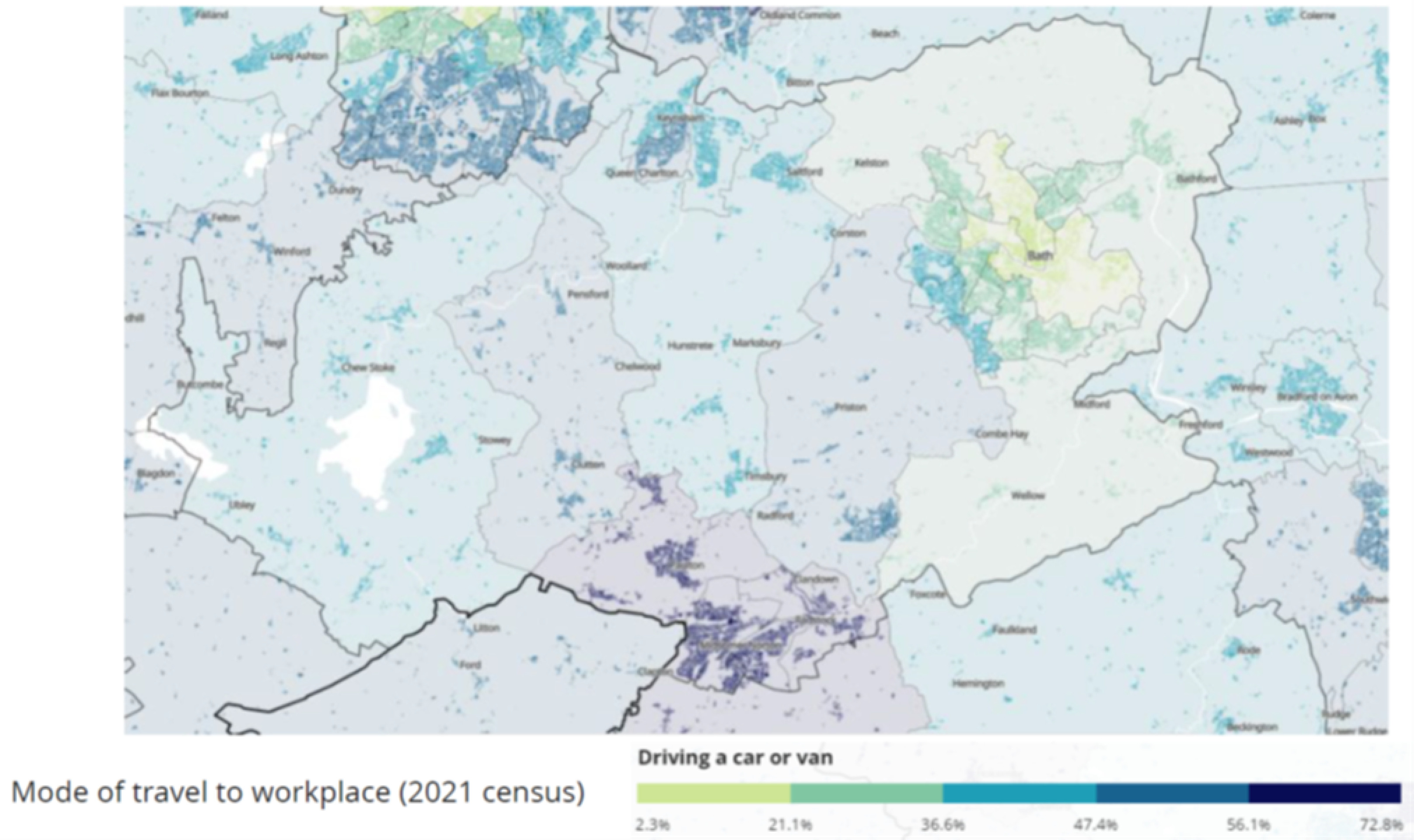
Being able to move around by sustainable means of transport, that is walking, cycling and wheeling or public transport, in order to easily access services and facilities, as well as places of work is vital in seeking to minimise carbon impact and addressing the climate emergency. Around 30% of carbon emissions in B&NES currently relate to transport. Since the Covid pandemic an increasing proportion of people work from home. However, at least some of the time, travelling to work is still an important journey for many, as well as regular journeys to access key services and facilities such as schools or Local Plan convenience shops. The maps below from the 2021 census provide a useful indication of the propensity to travel to work by car (as opposed to more sustainable means), as well as the distances travelled to work. The maps show that in 2021 a greater proportion of people travelled to work by car and travel a greater distance in the more rural parts of the district and also the Somer Valley.
Mode of travel to workplace by car or van (2021 census)
Thanks for your patience whilst we create a higher quality image
Click to enlarge
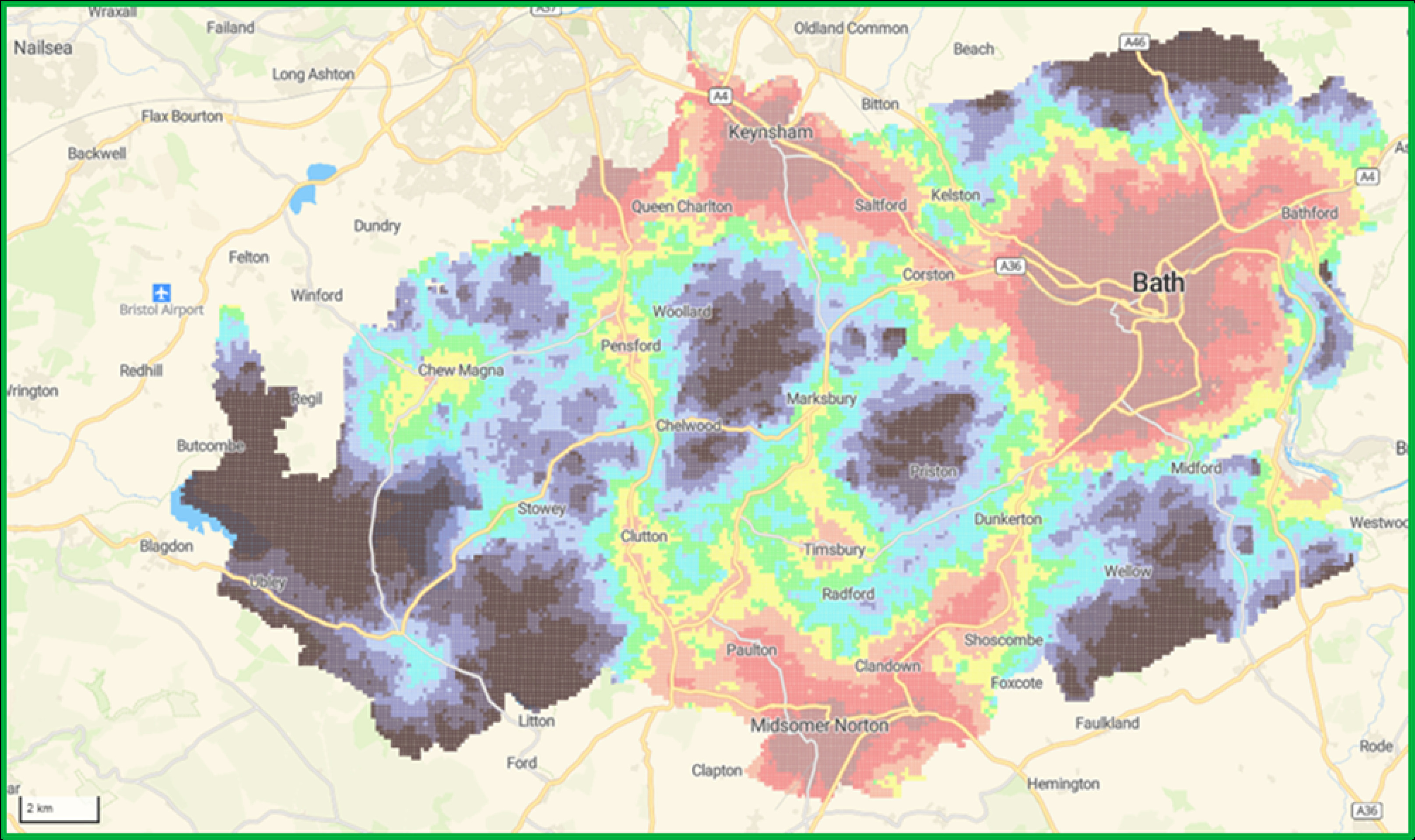
Analysis has also been undertaken of connectivity of different areas across Bath and North East Somerset by sustainable means of transport to a range of important services and facilities, as well as employment areas. In the spring 2024 options document, analysis undertaken by WECA was mapped and used to inform the identification and assessment of development location options. Since that time the Department of Transport has undertaken similar connectivity mapping for the whole country. This connectivity analysis is finer grained than that undertaken by WECA. The map below illustrates the results showing comparative sustainable connectivity within B&NES which is broadly aligned with those of WECA’s analysis. The areas shown in red/orange are the best connected by sustainable means of transport, moving through yellow/green and then blue/black for the least well connected. The connectivity analysis has also been used as the basis for assessing likely carbon impact of development in different locations.
Relative sustainable transport connectivity across B&NES
Click to enlarge
In the sub-area or place-based chapters that follow, each site option has been evaluated and graded using the Department for Transport’s Connectivity Tool, which by integrating transport and land use data produces a national measure of connectivity for any location in England and Wales. This tool assigns each location a grade from A to J, where A indicates the highest level of connectivity within Bath and North East Somerset, and J the lowest. The assessment is based on the current sustainable transport network and existing land uses such as schools and shops, and does not take into account planned or future improvements. The grading from A to J is not an overall ranking of site options and in in assessing and selecting which locations are taken forward for development in the Draft Local Plan the other factors or principles outlined will also be considered.
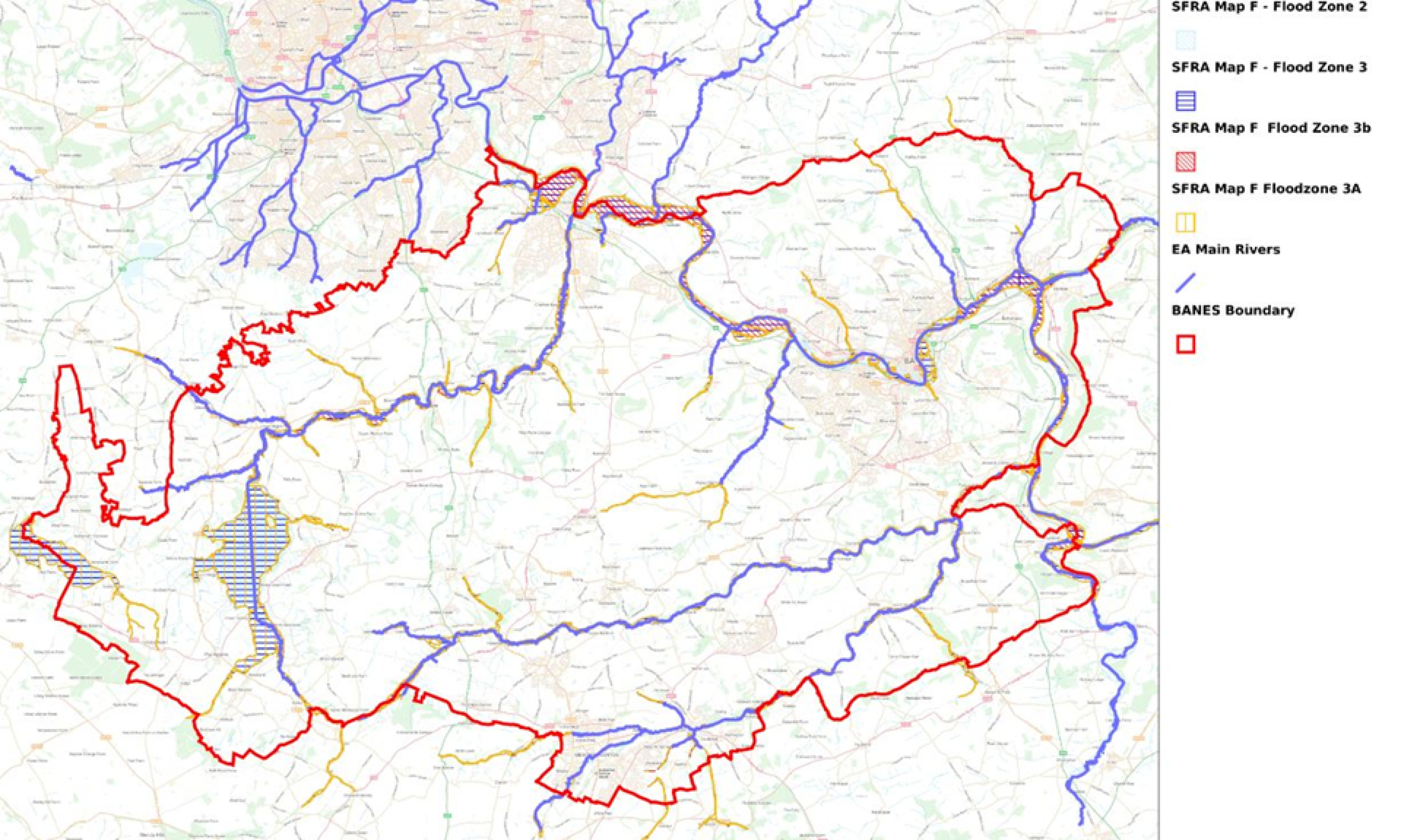
Bath and North East Somerset includes many waterways. Ensuring that flood risk is properly taken into account is another important factor influencing the location of development and resilience to climate change. Flood risk is initially considered through reference to the Level 1 Strategic Flood Risk Assessment in identifying flood risk areas arising from all sources of water, for B&NES these are primarily fluvial or river and surface water. The map below is taken from the latest SFRA (2022) and identifies flood risk zones. This informs a sequential approach to the identification of development locations, seeking to avoid locating vulnerable uses (e.g. residential development) in those areas at higher level of risk from flooding. The Level 1 SFRA is currently being updated to reflect the latest Environment Agency flood zone mapping and allowances for the impact of climate change to inform the Draft Local Plan. For some potential development areas or options a more detailed or Level 2 Flood Risk Assessment may be needed and this will also be undertaken to inform the next stages of the Local Plan.
Opportunities to mitigate increasing flood risks resulting from climate change through nature based interventions will also be considered to inform the next stage of the Local Plan.
SFRA Flood Zones
Thanks for your patience whilst we create a higher quality image
Click to enlarge
Enabling Local Plan food production has a number of important benefits e.g. in terms of climate change and achieving carbon neutrality by reducing food miles, as well as benefitting people’s health and wellbeing. In terms of using land efficiently it is also important to avoid the unnecessary loss of high-quality agricultural land. National policy makes it clear that the best and most versatile agricultural land should be protected, wherever possible, from significant development. The Agricultural Land Classification (ALC) classifies land into six grades (plus ‘non-agricultural’ and ‘urban’), where Grades 1 to 3a are recognised as being the best and most versatile land and Grades 3b to 5 are of poorer quality. Data from the provisional ALC shows that the majority of B&NES is underlain by Grade 3 (good to moderate quality) land; however, further clarity is needed in some areas as to whether this land is Grade 3a (best and most versatile) or Grade 3b (poorer quality). The quality of agricultural land will, therefore, influence spatial strategy and the choice of locations for strategic development, although further information on quality is likely to be required in preparing the Draft Local Plan.
In 2020 we declared an ecological emergency recognising the severity of the degradation of the natural environment and loss of wildlife, the consequences of this, and the urgent need to take action to restore nature. Protecting habitat and supporting nature’s recovery (including through Biodiversity Net Gain) are important objectives for the council. Opportunities to better facilitate nature’s recovery have been identified through the West of England LNRS (see Key Requirements) and will be supported by new and amended planning policy. The need to both protect priority habitats and species and facilitate nature recovery influence the spatial strategy, locations for development and opportunities to plan for strategic greenspaces which deliver for nature and people. The West of England LNRS identifies the following areas:
Areas that are already of importance to biodiversity. These are sites that are nationally designated for their value to nature, such as Sites of Special Scientific Interest (SSSIs), Special Areas of Conservation (SACs) and Special Protection Areas (SPAs). It also includes sites that are designated as Local Nature Reserves; sites that are Local Planly designated as Sites of Nature Conservation Interest (SNCIs), and/or are irreplaceable habitat including ancient woodland.
Focus Areas for Nature Recovery. This is where action to recover nature will have the biggest impact and is most feasible. These have been mapped to reflect the priorities for nature recovery, and include all of the mapped measures for nature recovery. The focus areas for nature recovery are referred to as ‘areas that could become of particular importance’ in regulation.
The identified and mapped focus areas for nature recovery may be of strategic significance in delivering BNG and planning greenspace opportunities for nature recovery. This will be further explored in preparing the Draft Local Plan. The LNRS mapped areas are set out in each of the sub-area or place-based chapters that follow.
The likely effects of the spatial strategy and locations for development on European protected species and habitats must also be assessed through a Habitats Regulations Assessment. A Habitats Regulations Assessment comprises two phases, a Screening Assessment to identify whether there are likely to be significant adverse effects as a result of development or at this stage of Local Plan plan preparation options for development, and if there are, a full Appropriate Assessment. Given the scale of growth that needs to be planned for because of the government’s figure of housing need it is likely that a full Appropriate Assessment will be needed to identify the impacts of development and mitigation measures. In preparing the Draft Local Plan the council will consider and liaise with Natural England on the selection of locations for development and the approach to addressing issues or effects that are identified through the Appropriate Assessment. The approach currently being considered would involve:
- Development and publication of Special Area of Conservation (SAC) Bat Guidance for B&NES
- Development of strategic mitigation projects to provide robust core areas for SAC bat foraging and commuting incorporating some robust grazing areas to support bat foraging, which could also provide some access to greenspace
- Development of regional approach to lighting, including standards for new highway/cycle paths infrastructure that may or may not need planning permission
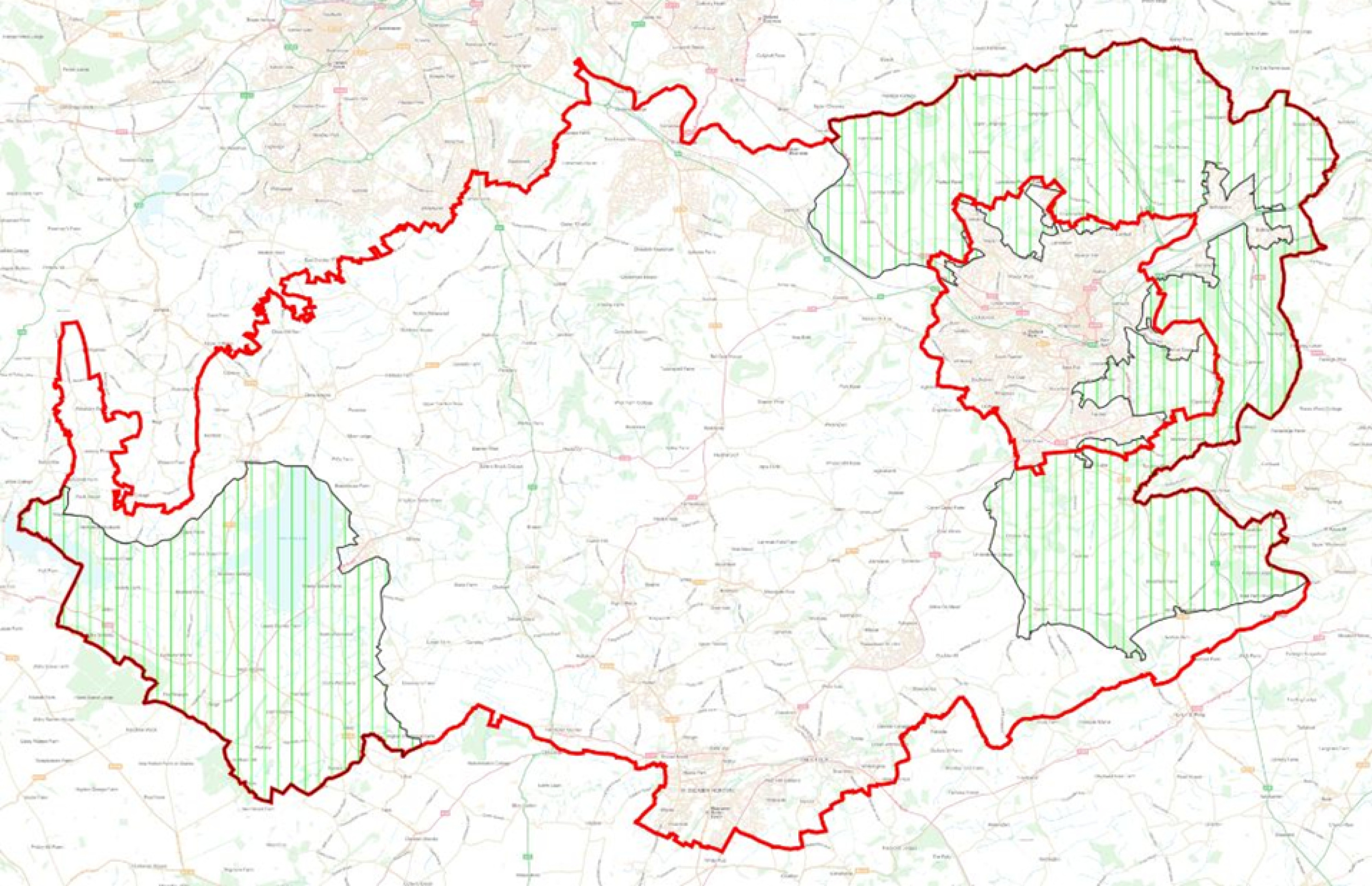
The landscape within Bath and North East Somerset enriches people’s lives and is an important influence on the location and form of new development. The attractiveness and character of the landscape should be maintained and enhanced for its own sake and because of the role it plays in residents’ quality of life and its economic benefits. The quality of the landscape is evidenced through national designations shown on the map below, including the Cotswolds National Landscape and Mendip Hills National Landscape. In addition to these designations Bath and North East Somerset is covered by a range of different landscape characters that are valued by those that live and work in and visit the district, as well as important landscape settings to settlements.
National Landscapes and World Heritage Sites in B&NES
Thanks for your patience whilst we create a higher quality image
Click to enlarge
In addition to the quality of its landscape Bath and North East Somerset has an historic environment that is of international and national significance. This is evidenced through a range of designations including the doubly inscribed World Heritage Site of Bath, numerous listed buildings, conservation areas and national Scheduled Ancient Monuments. The need to protect and enhance the significance of these heritage assets, including their settings, is also an important influence on spatial strategy and the location and form of development.
More than two-thirds of B&NES currently lies within the designated Bristol-Bath Green Belt. The Green Belt is designated to keep land permanently open. National policy outlines the five purposes of the Green Belt, summarised as follows:
- Check the unrestricted sprawl of large built up areas
- Prevent neighbouring towns from merging into one another
- Assist in safeguarding the countryside from encroachment
- Preserve the setting and special character of historic towns
- Assist urban regeneration by encouraging the recycling of derelict and urban land
The Bristol-Bath Green Belt was originally designated in the 1960s, primarily in order to check the unrestricted sprawl of Bristol and Bath and to ensure the two cities and surrounding towns do not merge. Land can only be removed from the Green Belt and allocated for development through a Local Plan plan and only if ‘exceptional circumstances’ exist. The Green Belt in Bath and North East Somerset has remained largely unchanged for many years, although land has been removed principally on the edge of Bath, Keynsham and Whitchurch for development through the B&NES Local Plan (2007) and Core Strategy (2014).
In December 2024 government set out some important changes to national policy on Green Belt. While retaining the importance and permanence of Green Belts the government requires Local Plan authorities to review their Green Belt if the need for development (as established through the standard method figure of housing need) cannot be sustainably met in any other way and is seeking for the strategic release of lower quality Green Belt for development to be considered. In identifying areas of lower quality Green Belt the government introduced the new concept of Grey Belt. Grey belt is defined as either previously developed land within the Green Belt or land that does not strongly serve purposes a, b or d as set out above. Guidance on how to identify areas of Grey Belt has also been set out by the government. In preparing the Local Plan plan and considering whether land from the Green Belt needs to be released for development we must do this sequentially, identifying and considering land in sustainable locations that is previously developed Grey Belt land, then other non-previously developed Grey Belt land, before considering other Green Belt land.
Through its revisions to national policy government has also set out its ‘golden rules’ relating to the release of land for development. These require that where land is released from the Green Belt for development an increased proportion of affordable housing is provided (either 50% or 15% above the proportion required elsewhere in B&NES); necessary improvements to Local Plan or national infrastructure are made; and the provision of new, or improvements to, existing green spaces that are accessible to the public. The improvements to green spaces should contribute positively to the landscape setting of the development, support nature recovery and meet Local Plan standards for green space provision where these exist in the development plan.
The Green Belt will be an important influence on the location of development in the district. It is clear that development of land currently within the Green Belt will need to be considered through the Local Plan plan in order that the evidenced need for further housing and employment development (see chapter 3) can be met. To understand and consider the impact of potential development on the Green Belt an assessment of the extent to which different parcels of land serve the five purposes is being undertaken. This represents stage 1 of strategically assessing and reviewing the Green Belt and also undertaking a high-level assessment of Grey Belt potential. This work is being undertaken covering the Bristol-Bath Green Belt across different Local Plan authority boundaries through a West of England Strategic Green Belt Assessment. The assessment work is ongoing and will inform the Draft Local Plan. Following the Strategic Green Belt Assessment a more detailed and granular (stage 2) assessment of the impact of development on more specific areas of the Green Belt within Bath and North East Somerset will also be required, including the identification or provisional identification of Grey Belt land.
It is crucial that new development is served by the timely provision of necessary supporting infrastructure e.g. transport, schools, health and social care facilities, utilities (including digital), green infrastructure (GI), etc. The council is a direct provider of some of this infrastructure and will identify requirements arising from any planned growth and seek to ensure timely provision to address such requirements. In addition, the council will continue to liaise with other external infrastructure providers e.g. utilities companies, in order to understand current deficiencies or surpluses in provision; what the infrastructure requirements are arising from new development; the most appropriate solutions and the barriers to delivering these solutions. Where barriers to infrastructure provision are insurmountable this would effectively prevent development taking place. Information from these discussions is referenced in the place-based chapters and in the Infrastructure Topic Paper
More detailed work on infrastructure requirements and delivery will be needed as the Local Plan plan progresses and the potential location options that are presented in this document are explored further. In addition to understanding the infrastructure requirements relating to individual development locations it will also be crucial to consider cumulative impact of development across a wider area both within and outside Bath and North East Somerset e.g. in relation to education and school places; health facilities; and transport. Solutions will therefore need to address both location-specific and cumulative impacts. At this stage the cumulative impact of development and infrastructure investment and provision required has not been undertaken because the choice of which development locations will be progressed has not yet been made. This work will be undertaken in collaboration with key infrastructure providers and agencies and will influence whether and how the need for additional development can be met.
The council’s GI (Green Infrastructure) Strategy is being updated and will guide delivery of the council’s GI policy and prioritising areas requiring investment, including the opportunity to plan for strategic parks or larger accessible green spaces to serve existing and new communities and provide multiple benefits.
Ground conditions, including land contamination and stability will also influence the choice of locations for development. Existing information has been used to inform this process, including understanding whether existing ground conditions are a ‘show-stopper’ for development or whether remediation costs are likely be very high. Where necessary it may be that more detailed assessments of specific areas to inform the Draft Local Plan are required.
In considering potential locations for development existing land use needs to be taken into account. Across the district the deficiency or surplus of land in different types of existing use must be considered in ensuring the needs of communities are met and a sustainable balance or mix of uses is maintained. For example, important community assets such as recreational space need to be protected or re-provided in an appropriate location.
In considering the choice of locations for future development it's important that we take account of the connection between them and air quality. Air quality must be considered at potential locations to ensure that we continue to improve Local Plan air quality for both existing and future residents across the district.
Local air pollution levels, air quality management areas and other air quality information have been used to inform the process. Where necessary it may be that more detailed information relating to specific areas and development use classes is required including prior to planning permission being granted to ensure cumulative air quality impact of developments are considered.