Maps of sub-areas in B&NES
Thanks for your patience whilst we create a higher quality image
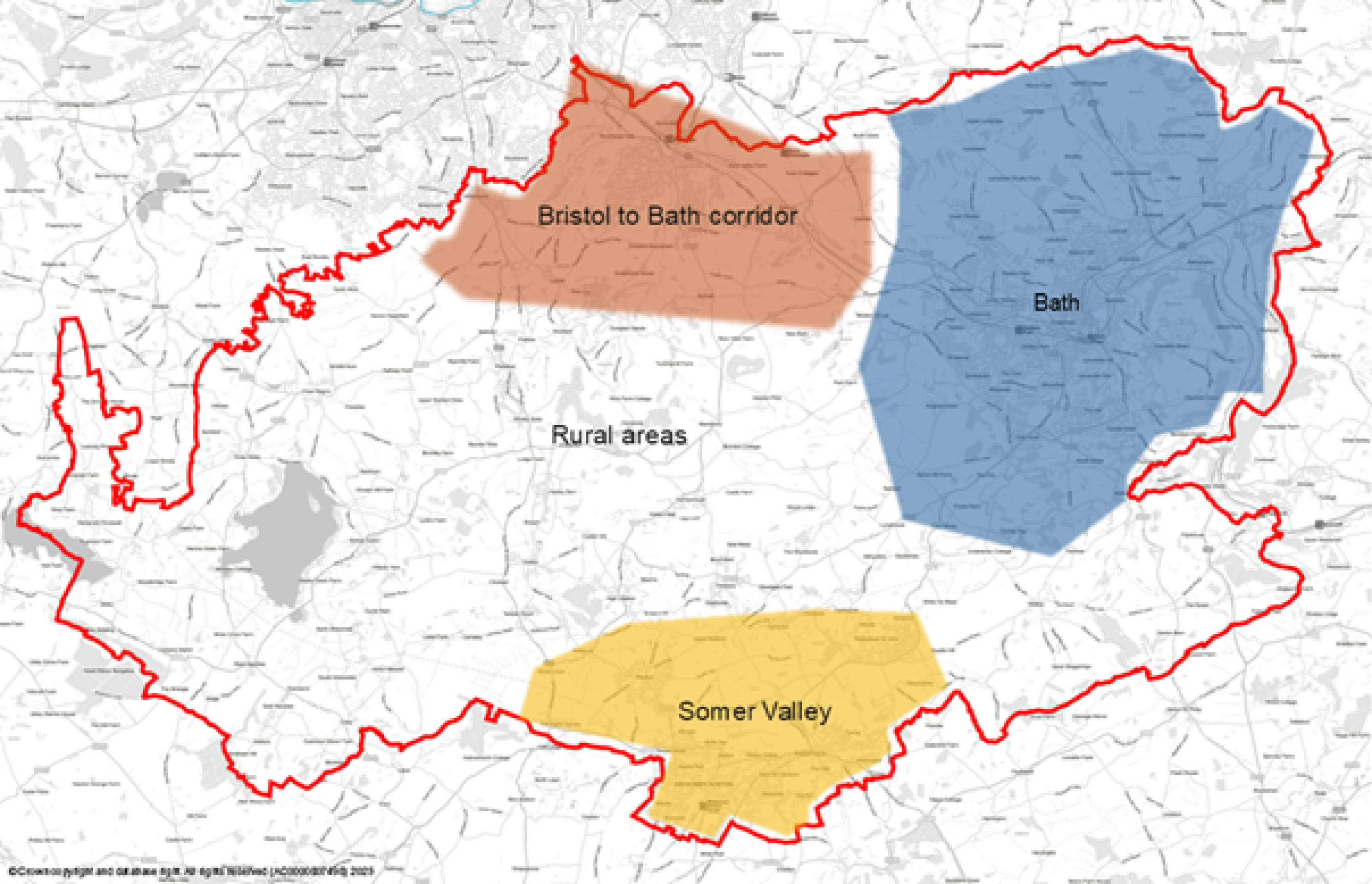
The City of Bath is the main economic centre and largest settlement within Bath and North East Somerset. As such it is the driver for a significant element of the housing needed in Bath and North East Somerset and is and will continue to be a focus for economic or employment space. The need for affordable housing is particularly acute in the city and, as set out in previous sections, the areas of the district where housing is least affordable (with house price to earnings ratio in the city being higher than the rest of the district). The city also hosts two Universities, which also bring with them significant opportunities but also major impacts on the city’s housing stock and communities. Bath is also a double-inscribed World Heritage Site, has a designated city-wide conservation area and is home to over 5,000 Listed Buildings. Furthermore, the city is tightly surrounded by the Green Belt and two-thirds of it is wrapped around by the Cotswolds National Landscape. Bath supports key components of the Bath & Bradford on Avon Bat Special Area of Conservation and the city retains significant wildlife interest particularly linked to the river corridor, hillsides and green fingers that characterise the city.
There is substantial pressure for development arising from housing and economic needs within the city, where land supply is limited and at a premium. Brownfield sites need to be re-developed where possible and at optimum densities in order to ensure such land is used efficiently, but in a way that respects the city’s sensitive context. Most of the significant brownfield sites have been redeveloped or are already committed for development and therefore, relatively few substantial new brownfield sites are available for development. Within this context the use of land within Bath needs to be carefully assessed and the needs which should be met must be prioritised. Opportunities for outward expansion of the city for both housing and employment space need to be explored and are set out in the Bath section. The villages that lie within the hinterland of the city are also of special character and development opportunities are limited. Options for development and which needs should be met and how are considered further in the Bath section. As is currently the case it is likely that residents in nearby settlements in key transport corridors linking to Bath will look to the city as their main urban centre and employment destination. The quality of sustainable transport connections to these settlements needs to be enhanced in order to enable sustainable movement.
Settlements within the transport and river corridor that connects Bath and Bristol, most notably Keynsham and Saltford village, but also other villages closer to Bath relate well to each other and are accessible by public transport in terms of people’s journeys for employment and services and facilities. Crucially these settlements are also well linked to Bristol and Bath by public transport, both bus and train from Keynsham. The south eastern edge of Bristol, in particular the Hicks Gate/Brislington area, also lies not far to the north west of Keynsham. In addition to this area the village of Whitchurch lies close to the south eastern edge of the City of Bristol. However, whilst it is relatively well connected into Bristol it is important to remember that Whitchurch village (like other villages) is a separate and distinct settlement and community. The corridor between Bristol and Bath is also identified as a priority growth zone in WECA’s emerging Local Growth Strategy.
The comparatively good public transport links are an important characteristic of this part of the district. However, it should be noted the main highway routes also suffer from congestion, especially at peak times. Therefore, investment is needed to further improve public transport services and active travel links. The potential opportunities are discussed in the Bristol to Bath section.
Land on the south east edge of Bristol and in the transport corridor linking Bath and Bristol lies within the Green Belt. Strategically this is an important part of the Green Belt in separating the two cities and the settlements that lie in between. The physical separation of not only Whitchurch village from Bristol, but also Keynsham from Bristol, and Keynsham and Saltford village are of great importance to the respective communities. In considering locations for development the need to retain, strengthen and enhance green infrastructure corridors is crucial. As set out above and in the context of revised national policy (including the new concept of Grey Belt) land can only be released from the Green Belt for development through a Local Plan and only if justified by ‘exceptional circumstances’. Potential locations for development in this part of the district, both for housing and employment space, as well as opportunities to provide high quality green infrastructure are considered in the Bristol to Bath section.
The River Avon corridor and supporting sub catchments are an important ecological network for the region, connecting Bath to Bristol and the communities between. The River Avon corridor also provides an important recreational route and sustainable movement corridor that can be enhanced for active travel for existing and new communities, and for boat dwellers living on the river. The River Chew, which is particularly relevant in having helped to shape Keynsham, is an important tributary of the River Avon.
The Somer Valley lies in the southern part of Bath and North East Somerset and adjoins the Somerset Council administrative area. For the purposes of the Local Plan, the Somer Valley area focusses on the six closely connected settlements of Midsomer Norton, Radstock, Westfield, Peasedown, Paulton and Farrington Gurney. Other villages in the wider Somer Valley (such as High Littleton and Timsbury) are considered in the rural areas sub-area (see below). The Somer Valley has a rich mining and industrial heritage and a locally distinctive character, including a number of derelict coal batches of wildlife and cultural interest. It is important that the character of each settlement is respected in considering potential development locations.
There has been considerable recent housing growth in the area, delivered on a piecemeal basis, without the necessary supporting infrastructure keeping pace. In addition, out-commuting from the area to work is relatively high and has increased in recent decades due to economic restructuring within the area.
The Somer Valley is connected to Bath and Bristol by two major transport corridors (A367 and A37) and is comparatively well served by public transport. Rural communities within the Somer Valley have recently seen a decline in bus services under the current private commercial operating model. To address this, further significant investment is needed to improve public transport. In addition, improvements to the active travel network are required to enhance connectivity and safety.
The Somer Valley is identified as a growth zone in WECA’s emerging Local Growth Strategy. It is important to improve local employment opportunities, including through delivery of the Somer Valley Enterprise Zone. Options for additional housing, employment space and the required infrastructure improvements are outlined in the Somer Valley section. Additionally, nature recovery and greater public access to greenspace must be delivered.
A significant proportion of Bath and North East Somerset is rural in nature. The rural areas are made up of several areas of attractive and distinct landscape and settlement character (e.g. the Chew Valley), as well as the Mendip Hills and Cotswolds National Landscapes. Spatially and functionally some villages are linked. This means that the rural areas can be further sub-divided based on character and/or spatially and functionally, further detail is set out in the Rural section.
Areas of strategic importance for nature recovery have been identified through the Local Nature Recovery Strategy and through the work of the Bristol Avon Catchment Partnership, and West of England Nature Partnership. The high quality of the environment and opportunities to access the countryside, as well as the strong sense of community identity in villages, are important to local communities. The connectivity by public transport from villages to larger urban centres is variable and is poor in some of the smaller villages, which also lack services and facilities that can be accessed by walking, cycling or wheeling.
As is the case across the district as a whole there is a lack of affordable housing available in order to help meet local needs. Some housing development in villages can provide much needed affordable housing, as well as help to keep services and facilities viable and operating. However, it is important that any development in the rural areas meets the needs of those communities, respects locally distinctive character and is primarily focussed on those villages that are better connected through sustainable means of transport and have better access to key services and facilities. Provision of additional employment space to provide increased local job opportunities in the rural areas and potentially reduce out-commuting also needs to be considered, including in conjunction with housing development. This is further explored in the Rural section.
Assessment of site options
Through the selection of location or site options that can help to meet the overall need for housing, employment development and supporting infrastructure we must ensure that the Plan’s spatial priorities are achieved. The key principles or factors outlined in the ‘Spatial Strategy Principles’ section have shaped the choice of settlements and location options. Specifically, relative sustainable transport connectivity and travel distances to employment opportunities and a range of key services and facilities was the starting point for identifying settlement and then location options to help minimise carbon impact. Consideration of the performance or impacts of these locations against the other spatial strategy principles, as well as a broader range of sustainability criteria has been undertaken and has influenced the selection of location options. The assessment of options (or ‘reasonable alternatives’) is outlined in supporting documents, importantly including the Sustainability Appraisal, the Housing and Employment Land Availability Assessment (HELAA) and the Area of Search Assessments/Topic Paper.
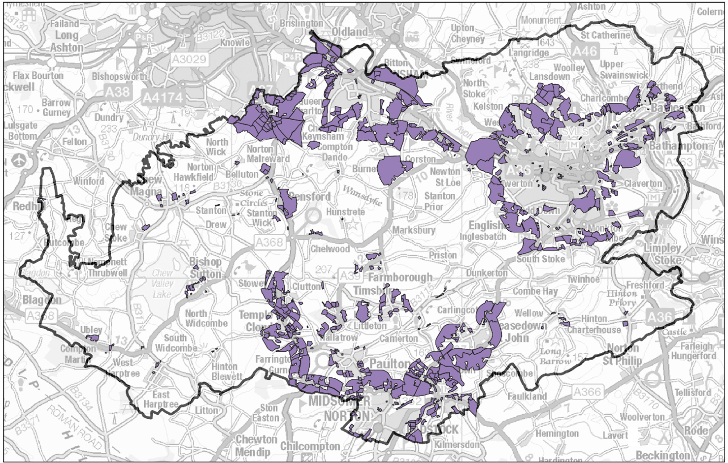
Through the HELAA a broad range of opportunities or sites across Bath and North East Somerset have been considered; in terms of their suitability, availability and achievability. The sites considered encompass those that have been submitted as potential development opportunities by landowners, developers and other stakeholders, supplemented by sites identified by the council where land in sustainable locations (primarily adjoining the main settlements) has not been submitted. The map below illustrates the range of HELAA sites considered across the district.
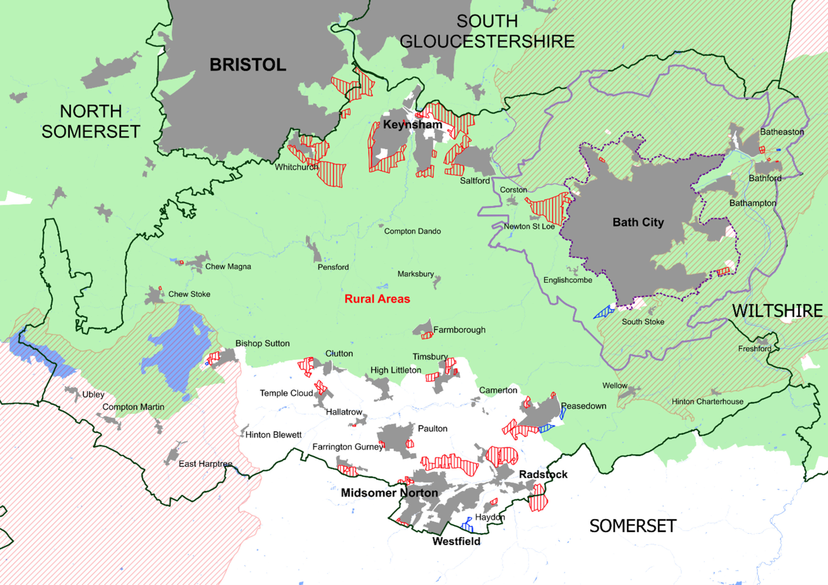
Those HELAA sites or groupings of HELAA sites assessed as being suitable, available and achievable for development that are located at the settlements identified as being the focus of strategic development have been considered against the spatial strategy principles referenced in the previous section and through the Sustainability Appraisal. This means that the broad range of HELAA sites has effectively been narrowed down to the potential options for strategic development within the Bristol to Bath growth corridor and the Somer Valley illustrated on the map above. Strategic sites or development is defined as that which is of a scale likely to require and support the provision of significant site-specific infrastructure and facilities e.g. dependent on location provision of a minimum of 500-600 dwellings could be sufficient to support the provision of a new single-form entry primary school. However, given single-form entry primary schools are often not economically viable there is a preference for a level of development that supports a two-form entry primary school and other key supporting infrastructure. Dependent on location this would be of a magnitude of 1,000-1,200 dwellings. Site options for employment space have also been identified, as well as considering those strategic sites on which some employment space could be provided as part of mixed use development in suitable locations for businesses.
HELAA sites that lie elsewhere in the district, perform poorly against the spatial strategy principles or are otherwise constrained have not been identified as options. It should be noted that only locations or opportunities for strategic development (rather than smaller, more local sites) are shown on this map.
In addition, options for non-strategic development, primarily in the Somer Valley and at the comparatively more sustainable villages are set out in the relevant place-based section. Where possible site options in villages have been identified and assessed through working with local communities. In order that a supply of deliverable sites for housing can be demonstrated it is necessary to identify a diverse range of sites, both larger, strategic sites which may take a little while for housing to be delivered and some smaller, non-strategic sites that are capable of coming forward for development more quickly.
In order to inform the selection and preparation of the most appropriate spatial strategy in the Draft Local Plan the sustainability of different combinations of locations or strategy approaches across the district is tested through the Sustainability Appraisal.
The testing of different strategy approaches through the Sustainability Appraisal enables the likely sustainability effects and advantages and disadvantages of different approaches to be identified.
Five strategy approaches are tested. These comprise two approaches which require significant release of land from the Green Belt (if justified by ‘exceptional circumstances’) in seeking to meet the standard method derived housing need and associated job growth outlined in the Key Requirements section. An alternative approach is tested that could potentially accommodate a higher level of growth, should this be necessary, and finally two approaches which are less reliant on Green Belt release that accommodate a lower level of growth e.g. if this is established as appropriate in light of cumulative impacts and associated infrastructure requirements of development. Comments are sought on both the individual location options, as well as the B&NES wide spatial strategy which should be pursued in the Draft Local Plan and the related role of the different sub-areas. The strategy approach and location options are also subject to Habitats Regulation Assessment to identify likely effects on European protected species and habitats and to help identify potential mitigation approaches (see previous section).
In addition, and as set out below the council is also considering whether one or more new settlements should form part of a longer-term strategy for meeting future development needs primarily beyond this Local Plan period (see new settlement methodology section below). This also need to be considered on a regional basis through the WECA Spatial Development Strategy.
HELAA Map
Strategic sites
The location or site options illustrated on the map are also listed by sub-area in the table below. The order in the table does not indicate a level of preference at this stage. In selecting which site options are taken forward for allocation in the Draft Local Plan current sustainable transport connectivity (see DfT transport connectivity grading) and opportunities to improve such connectivity, other sustainability criteria and deliverability factors will be considered.
Sustainable transport connectivity is based on government data on current connectivity to services, facilities and employment. It does not take into account measures that could improve sustainable transport connectivity which will be identified and assessed in preparing the Draft Local Plan. In the place-based sections that follow the sustainable transport connectivity is identified and illustrated on the site options maps and concept diagrams.
The table below also includes an indicative estimate of housing and/or employment space capacity. This indicative capacity is based on assumptions regarding both development densities and the proportion of a site on which built development will take place. At this stage the capacities are only indicative as further work needs to be undertaken on masterplanning the sites and testing their cumulative impacts and associated infrastructure requirements (this can only be progressed once we have certainty on which sites will be allocated). This work will be done to inform the Draft Local Plan. For the site options identified specifically for employment uses the employment space capacity or area is set out and for the other strategic sites only the housing capacity is set out in the table. On some of these strategic sites a greater mix of uses and potential employment space provision may be appropriate. These sites are indicated with an asterisk in the table and further analysis will be undertaken in preparing the Draft Local Plan to identify the amount and type of employment space that could be appropriately provided.
Only strategic site options are individually listed in the table below. In addition, a range of smaller, non-strategic site options are referenced in the place-based sections and the capacity of these sites also need to be included in identifying the total housing that could be delivered through the options presented. In total they could theoretically provide between 17,630 and 23,930 new homes against a requirement to allocate land for at least 19,900 to meet the government’s figure of housing need.
The location options summarised in the table below are explored in greater detail in the place-based sections that follow. Each of the options could play a role in helping to meet the identified overall housing and employment development requirements. We are seeking your comments on each of these location options and whether you consider they represent a good opportunity to address our need for housing and/or employment opportunities. Some of the location options were also presented in the spring 2024 options document. Comments previously submitted on these options will continue to be carefully considered by the council. These comments do not need to be re-submitted, however, any additional comments in the context of new information are welcomed. The new or extended options presented in these webpages are clearly indicated in the place-based sections to help focus review and responses.
Some of the location options listed and assessed (alongside other smaller non-strategic sites referenced in the dropdown above) will together comprise a district-wide approach or strategy in meeting development needs. As set out above the cumulative impacts of development and associated infrastructure requirements have not been assessed at this stage and therefore, it is not certain which development locations could be brought forward in combination with others. It is also clear that as set out in each place-based section, substantial infrastructure investment will be needed to enable development to come forward. The district-wide strategy will be set out in the Draft Local Plan published later in the year.
Location of strategic sites
Summary of strategic site capacity ranges
Note: sites shown in italics are employment space options and those with asterisk are strategic sites that could be mixed use with a strategic employment role.
| Location Option | Existing housing commitments | New sites - appx. housing capacity | New sites - appx. employment space provision |
| Bath | 4,293 | ||
| West of Bath* | 900 - 1,950 | ||
| Non-strategic sites, including Purpose Built Student Accommodation | 780 - 800 | ||
| Odd Down | 2-5ha | ||
| Bristol to Bath Corridor | 602 | ||
| Hicks Gate* | 1,200 - 1,550 | ||
| North Keynsham* | 1,900 - 2,400 | ||
| West/South West Keynsham | 1,000 - 1,300 | ||
| South East Keynsham | 350 - 500 | ||
| Non-strategic sites in Keynsham | 230 - 300 | ||
| West Saltford (north of A4)* | 300 - 350 | ||
| West Saltford (south of A4)* | 650 - 850 | ||
| South Saltford | 350 - 450 | ||
| (West Whitchurch (Whitchurch Option 1) | 350 - 450 | ||
| East Whitchurch: Horseworld and Woollard Lane (Whitchurch Option 2) | 1,000 -1,300 | ||
| North Whitchurch: Staunton Lane (Whitchurch Option 3) | 350 - 400 | ||
| South East Whitchurch (Whitchurch Option 4) * | 1,950 - 2,500 | ||
| Stockwood Lane | 300 - 400 | ||
| Somer Valley | 1,052 | ||
| South Peasedown (south of the by-pass) | 550 - 700 | ||
| South west Peasedown (north of Bath Road, A367) | 250 - 300 | ||
| Bath Business Park extensions | 7ha | ||
| North Radstock | 1,250 – 1,550 | ||
| Writhlington | 950 – 1,150 | ||
| Westfield Industrial Estate extension | 6ha | ||
| North of Midsomer Norton* | 1,000 | ||
| Farrington Gurney South | 400 - 500 | ||
| Somer Valley (non-strategic sites) | 950 – 1,200 | ||
| Rural Areas (non-strategic sites incorporating possible longer term phases) | 999 | 670 – 2,030 |
New Settlement Methodology
In seeking to plan for greater levels of housing and economic land the council has set out various spatial strategy approaches that could act as a focus for identifying additional sites for development. One potential option that requires serious consideration, particularly in response to the significant levels of housing that we need to plan for over the longer term and given that it may not be appropriate to continue expanding existing cities and towns, is that of new settlements.
It must be acknowledged early on however that this potential option is not considered to be deliverable within the current plan period. The complex land assembly and planning required for a new settlement of sufficient size to provide a reasonable degree of self-containment, will take a reasonably long time. As such it is proposed to consult on a methodology for identifying particular spatial locations for new settlements and that this can inform an ongoing process which will hopefully inform future iterations of the Local Plan. It should also be borne in mind that the West of England Mayoral Combined Authority is at the early stages of producing a Spatial Development Strategy for the wider area. It is expected that as part of this process that they consider a similar methodology for identifying new settlements.
Given the scale of growth that we are looking to address and the role of the Local Plan in exploring other spatial strategy options for meeting this growth, this section is seeking to outline the process for identifying options for larger settlements of around 5,000 to 10,000 dwellings. This scale of development would be capable of accommodating more day-to-day activities such as schools, shops and medical facilities so that they have a greater degree of self-sufficiency. It is abundantly clear that development of this scale would have a substantial impact on any locality and that these would need to be critically understood to ensure that the benefits for affected communities outweigh negative impacts.
There could be potential in the future to devise a secondary sifting process to identify the opportunities for smaller settlements or for a cluster of smaller new villages. However, given that the benefits, in terms of delivering housing numbers, is likely to be much less, the focus will remain on seeking to identify areas for strategic levels of growth.
In essence, the new settlement is considered to have the following key opportunities and constraints:
Opportunities
- A new or substantially expanded settlement allows for a comprehensive and strategic approach to provision of housing and economic land, enabling the integration of infrastructure such as transport, energy, education, green infrastructure, health and utilities to support the development from the start.
- Dependent on the location and size of a new settlement it could reduce the pressure on infrastructure, including local services and facilities, in existing towns and villages.
- New or substantially expanded settlements could also play a role in meeting housing need beyond the period of this Local Plan, as part of a longer-term strategy.
Constraints
- Requires extensive upfront investment for infrastructure which could impact the viability of the development.
- Given significant infrastructure requirements and complex process of bringing one forward it is likely that a new or substantially expanded settlement would have long lead in times and will not deliver housing or other uses in the short to medium term.
This section sets out a methodology for identifying potential locations for a new settlement.
To explore the potential scope for new settlements within B&NES it is proposed to set out a series of parameters which can guide the identification of locations. Where could be appropriate locations? What are the areas to avoid? What are the key issues that need to be considered? This is considered to be a key part of the sieving process to identify potential locations.
In ensuring that we plan for development that responds to local needs and creates attractive, healthy and sustainable places in line with the council’s Corporate Strategy, the following are considered to be the key constraints or parameters against which potential locations can be identified:
- Fundamental or major constraints e.g. flood zones, that would automatically discount areas. This list of constraints will also include: mine shafts, power lines, gas mains, sewage farms and buffer zones, SSSIs, SACs, SPA, priority habitats / LNRS, most SAMs, landscape and heritage constraints, NLs, Conservation Areas.
- Transport and levels of existing or potential public transport and active travel accessibility to larger settlements. This is a key priority for the Local Plan and is likely to favour locations that are well related to the principal roads throughout B&NES where levels of inter-urban accessibility enable people to make more sustainable travel choices to larger settlements such as Bath or Bristol. It is also essential to give significant weight to the potential improvements to public transport that could be made; the scale of new settlements being explored is such that significant improvements could have a reasonable prospect of being delivered.
- Level or gently undulating sites with limited moderate to steep slopes (? <20% site area). It is known that steeper slopes are more expensive to build on and therefore site deliverability may be an issue. It will be partly dependent on the assumed sales values that are able to be achieved and viability assessments will play a part in this. Ground and soil conditions are also key factors.
- Landscape character types and capacity to change. There are a wide range of different types of landscape character areas within B&NES. Much of the district is designated as part of either the Cotswold or Mendips National Landscapes and would be particularly challenging to change (although not insurmountable). Whilst all landscapes are valued, there are areas with a greater capacity to absorb development. Given the size of a potential new town, there is the potential to fund fairly significant levels of infrastructure that might address existing deficits. Reasonable access to basic infrastructure networks is an important consideration.
Following this initial methodology to identify potential locations, it will be necessary to devise a secondary sifting process which would ascertain how any identified locations perform when tested against the spatial priorities for the Local Plan and an assessment of their deliverability, particularly in relation to willing landowners.